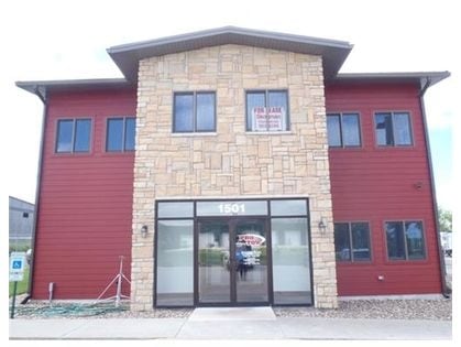
Property Record
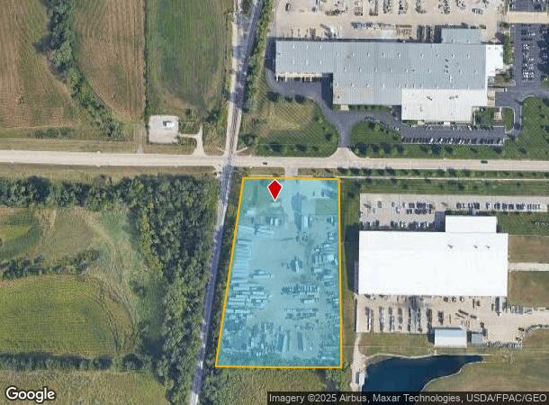
1501 76Th Ave Sw, Cedar Rapids, IA 52404
NEARBY LISTINGS FOR SALE OR LEASE
Property Detail
1501 76Th Ave Sw
Commercialnec
NE NW W 173.8 N660 EX RD & NW NW N660 E OF RR-EX RD STR/LB 20-82-7
X
Linn
19113C0415E
Iowa
2024
5.05 AC
2025
Other Market Areas
010700
Cedar Rapids, IA
1,696 SF
19202-01002-00000
DEMOGRAPHICS near 1501 76Th Ave Sw
1 Mile
3 Mile
5 Mile
2024 Total Population
4
8,918
53,876
2029 Population
4
8,928
54,091
Pop Growth 2024-2029
0.00%
+ 0.11%
+ 0.40%
Average Age
0
33
38
2024 Total Households
2
3,576
22,471
HH Growth 2024-2029
0.00%
+ 0.17%
+ 0.44%
Median Household Inc
$12,500
$53,119
$58,782
Avg Household Size
1.00
2.40
2.30
2024 Avg HH Vehicles
2.00
2.00
2.00
Median Home Value
$50,000
$165,325
$166,310
Median Year Built
1979
1996
1980
Nearby Places
Map Layers
Map Styles
 Street
 Aerial
- Restaurants
- Banks
- Shops
- Fitness
- Groceries
PUBLIC TRANSPORTATION
AIRPORT
The Eastern Iowa
DRIVE
WALK
Distance
The Eastern Iowa
7 min
3.0 mi
Freight Ports
Port Milwaukee
DRIVE
WALK
Distance
Port Milwaukee
303 min
254.1 mi
Nearby Properties
Address
Land Use
TOTAL SIZE
Lot Size
Zoning
Address
Land Use
TOTAL SIZE
Lot Size
Zoning
612,805 SF
21.93 AC
Address
Land Use
TOTAL SIZE
Lot Size
Zoning
269,397 SF
153.19 AC
Address
Land Use
TOTAL SIZE
Lot Size
Zoning
486,932 SF
40.73 AC
Address
Land Use
TOTAL SIZE
Lot Size
Zoning
1,012,084 SF
45.85 AC
Address
Land Use
TOTAL SIZE
Lot Size
Zoning
937.94 AC
Address
Land Use
TOTAL SIZE
Lot Size
Zoning
103,804 SF
46.29 AC
Address
Land Use
TOTAL SIZE
Lot Size
Zoning
231,824 SF
31.61 AC
Address
Land Use
TOTAL SIZE
Lot Size
Zoning
550,428 SF
78.91 AC
Address
Land Use
TOTAL SIZE
Lot Size
Zoning
142,137 SF
34.61 AC
Address
Land Use
TOTAL SIZE
Lot Size
Zoning
592,459 SF
45.65 AC
Address
Land Use
TOTAL SIZE
Lot Size
Zoning
172,000 SF
168.92 AC
Address
Land Use
TOTAL SIZE
Lot Size
Zoning
218,451 SF
18.74 AC
Address
Land Use
TOTAL SIZE
Lot Size
Zoning
202,762 SF
22.71 AC
Address
Land Use
TOTAL SIZE
Lot Size
Zoning
1,049,268 SF
79.35 AC
Address
Land Use
TOTAL SIZE
Lot Size
Zoning
243,300 SF
22.44 AC
Address
Land Use
TOTAL SIZE
Lot Size
Zoning
907,717 SF
152.19 AC
Address
Land Use
TOTAL SIZE
Lot Size
Zoning
142,780 SF
14.32 AC
Address
Land Use
TOTAL SIZE
Lot Size
Zoning
224,710 SF
22.66 AC
Address
Land Use
TOTAL SIZE
Lot Size
Zoning
350,770 SF
20.88 AC
Address
Land Use
TOTAL SIZE
Lot Size
Zoning
315,459 SF
13.85 AC
Address
Land Use
TOTAL SIZE
Lot Size
Zoning
157,850 SF
17.53 AC
Address
Land Use
TOTAL SIZE
Lot Size
Zoning
203,840 SF
18.22 AC
Address
Land Use
TOTAL SIZE
Lot Size
Zoning
205,013 SF
16.44 AC
Address
Land Use
TOTAL SIZE
Lot Size
Zoning
203,272 SF
17.80 AC
Address
Land Use
TOTAL SIZE
Lot Size
Zoning
30,185 SF
148.88 AC
Address
Land Use
TOTAL SIZE
Lot Size
Zoning
44,520 SF
7.28 AC
Address
Land Use
TOTAL SIZE
Lot Size
Zoning
60,096 SF
4.70 AC
Address
Land Use
TOTAL SIZE
Lot Size
Zoning
175,115 SF
30.13 AC
Address
Land Use
TOTAL SIZE
Lot Size
Zoning
210,000 SF
13.20 AC
Address
Land Use
TOTAL SIZE
Lot Size
Zoning
274,433 SF
17.68 AC
The World's #1 Commercial Real Estate Marketplace
Connect with us
© 2026 CoStar Group
The information above has been obtained from sources believed reliable. While we do not doubt its accuracy we have not verified it and make no guarantee, warranty or representation about it. It is your responsibility to independently confirm its accuracy and completeness. Any projections, opinions, assumptions, or estimates used are for example only and do not represent the current or future performance of the property. The value of this transaction to you depends on tax and other factors which should be evaluated by your tax, financial, and legal advisors. You and your advisors should conduct a careful, independent investigation of the property to determine to your satisfaction the suitability of the property for your needs.