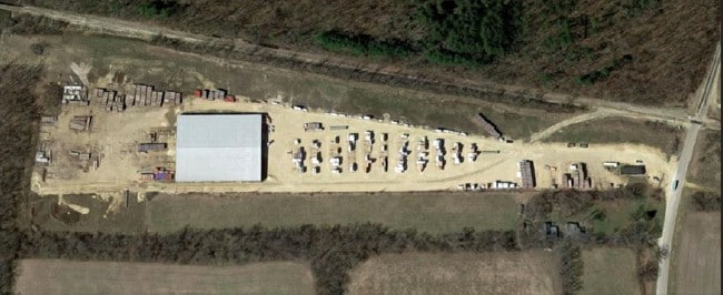
Property Record
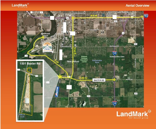
1501 Baxter Rd, Rockford, IL 61109

Property Detail
1501 Baxter Rd
15-35-100-008
RELOAD CENTER NO 2 PT SW1/4 SEC 26 & PT N1/2 SEC 35-43-1 LOT 4 17.60 AC
Industrialgeneral
WINNEBAGO
I1
Illinois
AE The base floodplain where base flood elevations are provided. AE Zones are now used on new format FIRMs instead of A1-A30 Zones.
4
2024
17.60 AC
2024
I-39 Cor/Winnebago Cy
003711
Chicago
51,520 SF
Rockford, IL
NEARBY LISTINGS FOR SALE OR LEASE
-
-
View all Rockford listings for sale on LoopNet.com
DEMOGRAPHICS near 1501 Baxter Rd
1 mile
3 mile
5 mile
2025 Total Population
149
3,687
24,227
2030 Population
147
3,676
24,289
Pop Growth 2025-2030
(1.34%)
(0.30%)
+ 0.26%
Average Age
44
45
40
2025 Total Households
59
1,497
9,788
HH Growth 2025-2030
0.00%
(0.27%)
+ 0.29%
Median Household Inc
$72,499
$77,701
$64,066
Avg Household Size
2.40
2.40
2.40
2025 Avg HH Vehicles
3.00
2.00
2.00
Median Home Value
$212,500
$167,449
$141,264
Median Year Built
1974
1976
1972
Nearby Places
Map Layers
Map Styles
 Street
 Aerial
Layers
 Traffic
 Biking
Places
Listings with unknown addresses are not visible on the map
- Restaurants
- Banks
- Shops
- Fitness
- Groceries
PUBLIC TRANSPORTATION
AIRPORT
Chicago/Rockford International
Drive
Walk
Distance
Chicago/Rockford International
14 min
4.1 mi
Freight Ports
Port Milwaukee
Drive
Walk
Distance
Port Milwaukee
125 min
102.3 mi
SALE & LEASE HISTORY
LISTING DATE
SALE/LEASE

May 03, 2023
For Lease
Dec 20, 2024
For Sale
Aug 20, 2024
For Sale
Aug 19, 2019
For Sale
Aug 02, 2019
For Lease
Aug 02, 2019
For Sale
Nearby Properties
Address
Land Use
TOTAL SIZE
Lot Size
Zoning
Address
Land Use
TOTAL SIZE
Lot Size
Zoning
555,920 SF
37.99 AC
I2
Address
Land Use
TOTAL SIZE
Lot Size
Zoning
369,006 SF
15.24 AC
I2
Address
Land Use
TOTAL SIZE
Lot Size
Zoning
192,476 SF
30.63 AC
I2
Address
Land Use
TOTAL SIZE
Lot Size
Zoning
2,393 SF
159.54 AC
Address
Land Use
TOTAL SIZE
Lot Size
Zoning
212,574 SF
9.57 AC
I3
Address
Land Use
TOTAL SIZE
Lot Size
Zoning
584,794 SF
34.40 AC
I3
Address
Land Use
TOTAL SIZE
Lot Size
Zoning
152,100 SF
4.19 AC
I2
Address
Land Use
TOTAL SIZE
Lot Size
Zoning
216,549 SF
9.18 AC
I2
Address
Land Use
TOTAL SIZE
Lot Size
Zoning
187,025 SF
12.82 AC
I3
Address
Land Use
TOTAL SIZE
Lot Size
Zoning
92,245 SF
5.67 AC
I3
Address
Land Use
TOTAL SIZE
Lot Size
Zoning
206,185 SF
21.09 AC
I3
Address
Land Use
TOTAL SIZE
Lot Size
Zoning
203,450 SF
31.79 AC
I3
Address
Land Use
TOTAL SIZE
Lot Size
Zoning
88.14 AC
Address
Land Use
TOTAL SIZE
Lot Size
Zoning
79,779 SF
17.50 AC
I2
Address
Land Use
TOTAL SIZE
Lot Size
Zoning
94,386 SF
4.89 AC
I3
Address
Land Use
TOTAL SIZE
Lot Size
Zoning
75.57 AC
Address
Land Use
TOTAL SIZE
Lot Size
Zoning
76,800 SF
5 AC
I3
Address
Land Use
TOTAL SIZE
Lot Size
Zoning
214,625 SF
18.66 AC
I3
Address
Land Use
TOTAL SIZE
Lot Size
Zoning
38,945 SF
10.02 AC
I3
Address
Land Use
TOTAL SIZE
Lot Size
Zoning
37,115 SF
42.96 AC
I1
Address
Land Use
TOTAL SIZE
Lot Size
Zoning
203,110 SF
2.72 AC
I2
Address
Land Use
TOTAL SIZE
Lot Size
Zoning
28.92 AC
I2
Address
Land Use
TOTAL SIZE
Lot Size
Zoning
20,160 SF
0.94 AC
I2
Address
Land Use
TOTAL SIZE
Lot Size
Zoning
36,812 SF
7.41 AC
I3
Address
Land Use
TOTAL SIZE
Lot Size
Zoning
66,650 SF
4.07 AC
I3
Address
Land Use
TOTAL SIZE
Lot Size
Zoning
37,827 SF
6.73 AC
I3
Address
Land Use
TOTAL SIZE
Lot Size
Zoning
Address
Land Use
TOTAL SIZE
Lot Size
Zoning
49,769 SF
4.16 AC
I2
Address
Land Use
TOTAL SIZE
Lot Size
Zoning
99,145 SF
4.18 AC
AG
Address
Land Use
TOTAL SIZE
Lot Size
Zoning
40,381 SF
4.17 AC
I2
The World's #1 Commercial Real Estate Marketplace
Connect with us
© 2026 CoStar Group
The information above has been obtained from sources believed reliable. While we do not doubt its accuracy we have not verified it and make no guarantee, warranty or representation about it. It is your responsibility to independently confirm its accuracy and completeness. Any projections, opinions, assumptions, or estimates used are for example only and do not represent the current or future performance of the property. The value of this transaction to you depends on tax and other factors which should be evaluated by your tax, financial, and legal advisors. You and your advisors should conduct a careful, independent investigation of the property to determine to your satisfaction the suitability of the property for your needs.