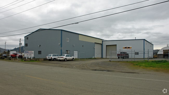
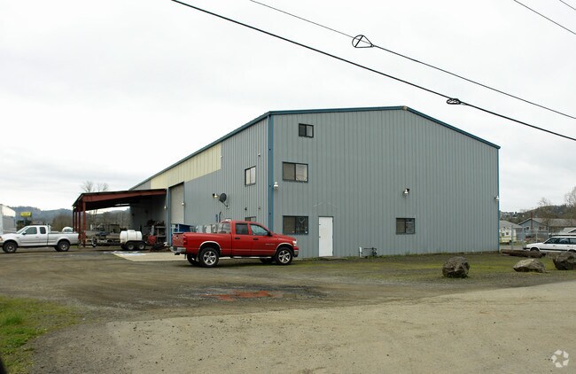
Property Record
1501 Green Siding Rd, Roseburg, OR 97471

Property Detail
1501 Green Siding Rd
R36737
P.P. 1994-94, PARCEL PT 1 (M&B INST 2025-12175), ACRES 1.84
Industrialgeneral
Douglas
M2
Oregon
B and X Area of moderate flood hazard, usually the area between the limits of the 100-year and 500-year floods.
1.84 AC
2025
Oregon West Area
2025
Other Market Areas
150001
Roseburg, OR
23,007 SF
NEARBY LISTINGS FOR SALE OR LEASE
-
-
View all Roseburg listings for lease on LoopNet.com
DEMOGRAPHICS near 1501 Green Siding Rd
1 mile
3 mile
5 mile
2025 Total Population
5,620
13,186
33,299
2030 Population
5,659
13,282
33,747
Pop Growth 2025-2030
+ 0.69%
+ 0.73%
+ 1.35%
Average Age
41
42
42
2025 Total Households
2,149
5,109
13,449
HH Growth 2025-2030
+ 0.70%
+ 0.70%
+ 1.38%
Median Household Inc
$68,183
$63,440
$58,522
Avg Household Size
2.50
2.50
2.40
2025 Avg HH Vehicles
2.00
2.00
2.00
Median Home Value
$271,832
$288,189
$296,569
Median Year Built
1985
1987
1977
Nearby Places
Map Layers
Map Styles
 Street
 Aerial
Transit
 Traffic
 Biking
Places
Listings with unknown addresses are not visible on the map
- Restaurants
- Banks
- Shops
- Fitness
- Groceries
SALE & LEASE HISTORY
LISTING DATE
SALE/LEASE

Mar 15, 2018
For Lease
Feb 27, 2023
For Lease
Nearby Properties
Address
Land Use
TOTAL SIZE
Lot Size
Zoning
Address
Land Use
TOTAL SIZE
Lot Size
Zoning
5 AC
PR
Address
Land Use
TOTAL SIZE
Lot Size
Zoning
40 AC
M3
Address
Land Use
TOTAL SIZE
Lot Size
Zoning
13.73 AC
M2
Address
Land Use
TOTAL SIZE
Lot Size
Zoning
35.26 AC
PR
Address
Land Use
TOTAL SIZE
Lot Size
Zoning
5,598 SF
349.39 AC
A-O
Address
Land Use
TOTAL SIZE
Lot Size
Zoning
8,698 SF
14.50 AC
C3
Address
Land Use
TOTAL SIZE
Lot Size
Zoning
5 AC
M3
Address
Land Use
TOTAL SIZE
Lot Size
Zoning
440 SF
64.40 AC
PR
Address
Land Use
TOTAL SIZE
Lot Size
Zoning
72,436 SF
9.70 AC
M2
Address
Land Use
TOTAL SIZE
Lot Size
Zoning
40.01 AC
M3
Address
Land Use
TOTAL SIZE
Lot Size
Zoning
13.05 AC
PR
Address
Land Use
TOTAL SIZE
Lot Size
Zoning
35,824 SF
3.82 AC
C2
Address
Land Use
TOTAL SIZE
Lot Size
Zoning
39.70 AC
M3
Address
Land Use
TOTAL SIZE
Lot Size
Zoning
41,124 SF
4.11 AC
CG
Address
Land Use
TOTAL SIZE
Lot Size
Zoning
9.81 AC
Address
Land Use
TOTAL SIZE
Lot Size
Zoning
2.40 AC
PR
Address
Land Use
TOTAL SIZE
Lot Size
Zoning
252.09 AC
CH
Address
Land Use
TOTAL SIZE
Lot Size
Zoning
1,008 SF
15.27 AC
M3
Address
Land Use
TOTAL SIZE
Lot Size
Zoning
19,218 SF
0.79 AC
CG
Address
Land Use
TOTAL SIZE
Lot Size
Zoning
22.59 AC
M3
Address
Land Use
TOTAL SIZE
Lot Size
Zoning
39,064 SF
3.43 AC
C3
Address
Land Use
TOTAL SIZE
Lot Size
Zoning
7.02 AC
M2
Address
Land Use
TOTAL SIZE
Lot Size
Zoning
9,862 SF
5 AC
FF
Address
Land Use
TOTAL SIZE
Lot Size
Zoning
Address
Land Use
TOTAL SIZE
Lot Size
Zoning
9.82 AC
M2
Address
Land Use
TOTAL SIZE
Lot Size
Zoning
43,500 SF
7.46 AC
M2
Address
Land Use
TOTAL SIZE
Lot Size
Zoning
54,342 SF
4.42 AC
M2
Address
Land Use
TOTAL SIZE
Lot Size
Zoning
116,277 SF
9.40 AC
M2
Address
Land Use
TOTAL SIZE
Lot Size
Zoning
4,050 SF
0.85 AC
C2
Address
Land Use
TOTAL SIZE
Lot Size
Zoning
1,167 SF
44.13 AC
PR
The World's #1 Commercial Real Estate Marketplace
Connect with us
© 2026 CoStar Group
The information above has been obtained from sources believed reliable. While we do not doubt its accuracy we have not verified it and make no guarantee, warranty or representation about it. It is your responsibility to independently confirm its accuracy and completeness. Any projections, opinions, assumptions, or estimates used are for example only and do not represent the current or future performance of the property. The value of this transaction to you depends on tax and other factors which should be evaluated by your tax, financial, and legal advisors. You and your advisors should conduct a careful, independent investigation of the property to determine to your satisfaction the suitability of the property for your needs.