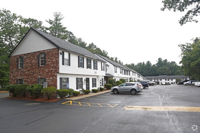
Property Record
1501 Main St, Tewksbury, MA 01876

NEARBY LISTINGS FOR SALE OR LEASE
Property Detail
1501 Main St
Officecondo
Middlesex
X
Massachusetts
25017C0276G
9
2025
Lowell/Chelmsford
2025
Boston
315500
Boston-Cambridge-Newton, MA-NH
1,050 SF
TEWK-000073-000000-000009-U000001
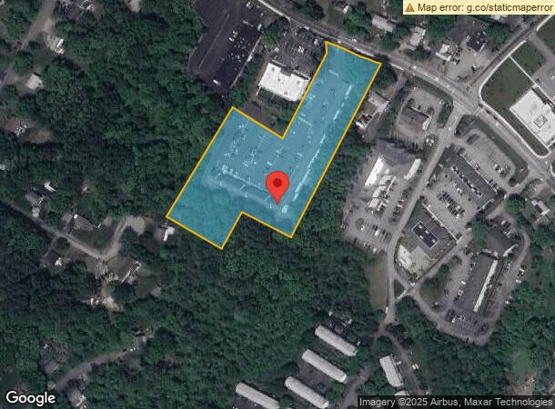
DEMOGRAPHICS near 1501 Main St
1 Mile
3 Mile
5 Mile
2024 Total Population
6,211
43,093
129,856
2029 Population
6,136
42,552
128,468
Pop Growth 2024-2029
(1.21%)
(1.26%)
(1.07%)
Average Age
46
44
42
2024 Total Households
2,451
15,766
46,973
HH Growth 2024-2029
(1.22%)
(1.34%)
(1.18%)
Median Household Inc
$98,404
$117,458
$117,559
Avg Household Size
2.30
2.60
2.70
2024 Avg HH Vehicles
2.00
2.00
2.00
Median Home Value
$443,317
$529,221
$533,026
Median Year Built
1982
1979
1973
Nearby Places
Map Layers
Map Styles
 Street
 Aerial
- Restaurants
- Banks
- Shops
- Fitness
- Groceries
PUBLIC TRANSPORTATION
COMMUTER RAIL
North Wilmington (Haverhill Line - Massachusetts Bay Transportation Authority Commuter Rail (Purple Line))
DRIVE
WALK
Distance
North Wilmington (Haverhill Line - Massachusetts Bay Transportation Authority Commuter Rail (Purple Line))
10 min
4.5 mi
North Billerica (Lowell Line - Massachusetts Bay Transportation Authority Commuter Rail (Purple Line))
DRIVE
WALK
Distance
North Billerica (Lowell Line - Massachusetts Bay Transportation Authority Commuter Rail (Purple Line))
11 min
4.5 mi
AIRPORT
General Edward Lawrence Logan International
DRIVE
WALK
Distance
General Edward Lawrence Logan International
36 min
22.9 mi
Manchester Boston Regional
DRIVE
WALK
Distance
Manchester Boston Regional
52 min
34.5 mi
Freight Ports
Port of Boston
DRIVE
WALK
Distance
Port of Boston
37 min
22.7 mi
SALE & LEASE HISTORY
LISTING DATE
SALE/LEASE

Sep 21, 2023
For Lease
Sep 13, 2024
For Sale
Sep 07, 2017
For Lease
Jun 21, 2023
For Lease
Jul 14, 2025
For Lease
Jul 11, 2019
For Lease
Feb 20, 2018
For Lease
Dec 20, 2022
For Lease
Aug 01, 2024
For Lease
Apr 16, 2024
For Lease
Nearby Properties
Address
Land Use
TOTAL SIZE
Lot Size
Zoning
Address
Land Use
TOTAL SIZE
Lot Size
Zoning
52.80 AC
OR
Address
Land Use
TOTAL SIZE
Lot Size
Zoning
25 AC
MN
Address
Land Use
TOTAL SIZE
Lot Size
Zoning
1,616 SF
206.08 AC
R40
Address
Land Use
TOTAL SIZE
Lot Size
Zoning
591,906 SF
153.43 AC
IA
Address
Land Use
TOTAL SIZE
Lot Size
Zoning
19.04 AC
MFD
Address
Land Use
TOTAL SIZE
Lot Size
Zoning
218,780 SF
55.49 AC
MN
Address
Land Use
TOTAL SIZE
Lot Size
Zoning
608,598 SF
21.08 AC
5
Address
Land Use
TOTAL SIZE
Lot Size
Zoning
40.44 AC
MFD
Address
Land Use
TOTAL SIZE
Lot Size
Zoning
161,736 SF
13.91 AC
Address
Land Use
TOTAL SIZE
Lot Size
Zoning
447,869 SF
27.06 AC
ID
Address
Land Use
TOTAL SIZE
Lot Size
Zoning
484,857 SF
42.05 AC
HI
Address
Land Use
TOTAL SIZE
Lot Size
Zoning
9.80 AC
R40
Address
Land Use
TOTAL SIZE
Lot Size
Zoning
180,640 SF
16.24 AC
ID2
Address
Land Use
TOTAL SIZE
Lot Size
Zoning
113,912 SF
5.67 AC
MFD
Address
Land Use
TOTAL SIZE
Lot Size
Zoning
107,001 SF
21.82 AC
MN
Address
Land Use
TOTAL SIZE
Lot Size
Zoning
135,500 SF
17.96 AC
OR
Address
Land Use
TOTAL SIZE
Lot Size
Zoning
73.74 AC
IH
Address
Land Use
TOTAL SIZE
Lot Size
Zoning
120,682 SF
12.03 AC
ID2
Address
Land Use
TOTAL SIZE
Lot Size
Zoning
187,898 SF
14 AC
IND
Address
Land Use
TOTAL SIZE
Lot Size
Zoning
70,470 SF
20.51 AC
R20/60
Address
Land Use
TOTAL SIZE
Lot Size
Zoning
98,247 SF
17.74 AC
5
Address
Land Use
TOTAL SIZE
Lot Size
Zoning
14.31 AC
5
Address
Land Use
TOTAL SIZE
Lot Size
Zoning
92,380 SF
2.66 AC
COM
Address
Land Use
TOTAL SIZE
Lot Size
Zoning
177,112 SF
13.86 AC
IND
Address
Land Use
TOTAL SIZE
Lot Size
Zoning
153,271 SF
24.66 AC
OR
Address
Land Use
TOTAL SIZE
Lot Size
Zoning
117,276 SF
11.05 AC
COM
Address
Land Use
TOTAL SIZE
Lot Size
Zoning
25 AC
OR
Address
Land Use
TOTAL SIZE
Lot Size
Zoning
100,594 SF
14.27 AC
IND
Address
Land Use
TOTAL SIZE
Lot Size
Zoning
86,670 SF
6.31 AC
Address
Land Use
TOTAL SIZE
Lot Size
Zoning
2,804 SF
162.20 AC
R40
The World's #1 Commercial Real Estate Marketplace
Connect with us
© 2025 CoStar Group
The information above has been obtained from sources believed reliable. While we do not doubt its accuracy we have not verified it and make no guarantee, warranty or representation about it. It is your responsibility to independently confirm its accuracy and completeness. Any projections, opinions, assumptions, or estimates used are for example only and do not represent the current or future performance of the property. The value of this transaction to you depends on tax and other factors which should be evaluated by your tax, financial, and legal advisors. You and your advisors should conduct a careful, independent investigation of the property to determine to your satisfaction the suitability of the property for your needs.