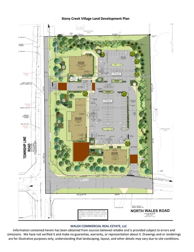
Property Record
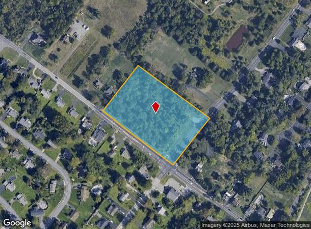
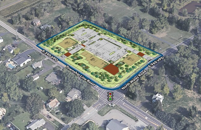
1501 N Wales Rd, Norristown, PA 19403
This Property Is For Sale
NEARBY LISTINGS FOR SALE OR LEASE
Property Detail
1501 N Wales Rd
Philadelphia-Camden-Wilmington, PA-NJ-DE-MD
ASSESSOR BLOCK-UNIT NUMBER 21-17
67-00-02608-007
Montgomery
Recreationalacreage
Pennsylvania
X
17
42091C0262G
4.50 AC
2024
West Montgomery County
2025
Philadelphia
206801
DEMOGRAPHICS near 1501 N Wales Rd
1 Mile
3 Mile
5 Mile
2024 Total Population
6,119
67,185
161,650
2029 Population
6,203
68,545
164,524
Pop Growth 2024-2029
+ 1.37%
+ 2.02%
+ 1.78%
Average Age
45
42
42
2024 Total Households
2,414
25,709
62,787
HH Growth 2024-2029
+ 1.37%
+ 2.05%
+ 1.79%
Median Household Inc
$95,133
$94,550
$95,397
Avg Household Size
2.50
2.50
2.50
2024 Avg HH Vehicles
2.00
2.00
2.00
Median Home Value
$351,797
$341,925
$369,627
Median Year Built
1964
1971
1971
Nearby Places
- Restaurants
- Banks
- Shops
- Fitness
- Groceries
PUBLIC TRANSPORTATION
COMMUTER RAIL
Elm Street (Norristown) (R6 - Southeastern Pennsylvania Transportation Authority Regional Rail (SEPTA Regional Rail))
DRIVE
WALK
Distance
Elm Street (Norristown) (R6 - Southeastern Pennsylvania Transportation Authority Regional Rail (SEPTA Regional Rail))
10 min
4.0 mi
Main Street (Norristown) (R6 - Southeastern Pennsylvania Transportation Authority Regional Rail (SEPTA Regional Rail))
DRIVE
WALK
Distance
Main Street (Norristown) (R6 - Southeastern Pennsylvania Transportation Authority Regional Rail (SEPTA Regional Rail))
10 min
4.3 mi
AIRPORT
Philadelphia International
DRIVE
WALK
Distance
Philadelphia International
49 min
30.5 mi
Trenton Mercer
DRIVE
WALK
Distance
Trenton Mercer
56 min
38.9 mi
Lehigh Valley International
DRIVE
WALK
Distance
Lehigh Valley International
65 min
46.5 mi
Freight Ports
Port of Philadelphia
DRIVE
WALK
Distance
Port of Philadelphia
40 min
20.0 mi
Nearby Properties
Address
Land Use
TOTAL SIZE
Lot Size
Zoning
Address
Land Use
TOTAL SIZE
Lot Size
Zoning
1,807,465 SF
120.12 AC
R2
Address
Land Use
TOTAL SIZE
Lot Size
Zoning
365,348 SF
80.44 AC
IN
Address
Land Use
TOTAL SIZE
Lot Size
Zoning
688,123 SF
190.06 AC
IN
Address
Land Use
TOTAL SIZE
Lot Size
Zoning
476,392 SF
54.50 AC
I
Address
Land Use
TOTAL SIZE
Lot Size
Zoning
610,455 SF
103.65 AC
R6
Address
Land Use
TOTAL SIZE
Lot Size
Zoning
422,975 SF
92.05 AC
RA
Address
Land Use
TOTAL SIZE
Lot Size
Zoning
505,128 SF
12.11 AC
RE
Address
Land Use
TOTAL SIZE
Lot Size
Zoning
217,564 SF
12.64 AC
IN
Address
Land Use
TOTAL SIZE
Lot Size
Zoning
231,665 SF
26.34 AC
OSR
Address
Land Use
TOTAL SIZE
Lot Size
Zoning
381,496 SF
5.37 AC
EC
Address
Land Use
TOTAL SIZE
Lot Size
Zoning
311,142 SF
39.51 AC
R1
Address
Land Use
TOTAL SIZE
Lot Size
Zoning
53,368 SF
38.59 AC
R3
Address
Land Use
TOTAL SIZE
Lot Size
Zoning
213,070 SF
29.67 AC
RE
Address
Land Use
TOTAL SIZE
Lot Size
Zoning
703,182 SF
84.25 AC
LI
Address
Land Use
TOTAL SIZE
Lot Size
Zoning
416,392 SF
26.56 AC
HR
Address
Land Use
TOTAL SIZE
Lot Size
Zoning
205,344 SF
26.67 AC
RE
Address
Land Use
TOTAL SIZE
Lot Size
Zoning
311,784 SF
21.82 AC
A
Address
Land Use
TOTAL SIZE
Lot Size
Zoning
136,637 SF
18 AC
OSR
Address
Land Use
TOTAL SIZE
Lot Size
Zoning
211,739 SF
14.14 AC
CR
Address
Land Use
TOTAL SIZE
Lot Size
Zoning
133,012 SF
32.23 AC
IN
Address
Land Use
TOTAL SIZE
Lot Size
Zoning
172,689 SF
18.74 AC
AR
Address
Land Use
TOTAL SIZE
Lot Size
Zoning
337,873 SF
10.81 AC
HR
Address
Land Use
TOTAL SIZE
Lot Size
Zoning
191,042 SF
9.59 AC
R6
Address
Land Use
TOTAL SIZE
Lot Size
Zoning
121,152 SF
6.56 AC
CI
Address
Land Use
TOTAL SIZE
Lot Size
Zoning
194,686 SF
10.39 AC
IN
Address
Land Use
TOTAL SIZE
Lot Size
Zoning
102,468 SF
11.48 AC
C
Address
Land Use
TOTAL SIZE
Lot Size
Zoning
109,066 SF
31.76 AC
IN
Address
Land Use
TOTAL SIZE
Lot Size
Zoning
207,661 SF
20 AC
SC
Address
Land Use
TOTAL SIZE
Lot Size
Zoning
160,763 SF
3.84 AC
EC
Address
Land Use
TOTAL SIZE
Lot Size
Zoning
155,614 SF
10.60 AC
RE
The World's #1 Commercial Real Estate Marketplace
Connect with us
© 2025 CoStar Group
The information above has been obtained from sources believed reliable. While we do not doubt its accuracy we have not verified it and make no guarantee, warranty or representation about it. It is your responsibility to independently confirm its accuracy and completeness. Any projections, opinions, assumptions, or estimates used are for example only and do not represent the current or future performance of the property. The value of this transaction to you depends on tax and other factors which should be evaluated by your tax, financial, and legal advisors. You and your advisors should conduct a careful, independent investigation of the property to determine to your satisfaction the suitability of the property for your needs.