Property Record
1501 Nw 18Th St, Pompano Beach, FL 33069

NEARBY LISTINGS FOR SALE OR LEASE
Property Detail
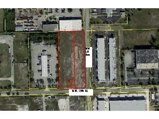
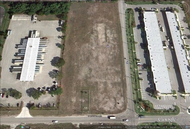
1501 Nw 18Th St
Fort Lauderdale-Pompano Beach-Deerfield Beach, FL
Paramount Park
48-42-27-53-0010
PARAMOUNT PARK 183-371 B A PAR OF LAND LYING IN SE1/4 OF NW1/4 OF SEC 27-48-42 DESC AS: COMM AT CENTER OF SEC 27,W ALG S/L OF SE1/4 OF NW1/4 OF SEC 27 & C/L OF NW 18 ST 205, N 35, CONT N 36 TO POB, CONT N 56, W 30, S 56, E 30 TO POB
Industrialacreage
Broward
X
Florida
12099C1175F
4.09 AC
2024
Pompano Beach
2025
South Florida
030806
DEMOGRAPHICS near 1501 Nw 18Th St
1 Mile
3 Mile
5 Mile
2024 Total Population
4,460
124,397
365,530
2029 Population
4,404
124,772
368,314
Pop Growth 2024-2029
(1.26%)
+ 0.30%
+ 0.76%
Average Age
36
42
44
2024 Total Households
1,299
49,747
156,007
HH Growth 2024-2029
(1.69%)
+ 0.28%
+ 0.90%
Median Household Inc
$57,020
$52,145
$59,646
Avg Household Size
3.30
2.30
2.20
2024 Avg HH Vehicles
2.00
1.00
2.00
Median Home Value
$233,055
$227,387
$308,072
Median Year Built
1981
1978
1977
Nearby Places
Map Layers
Map Styles
 Street
 Aerial
- Restaurants
- Banks
- Shops
- Fitness
- Groceries
PUBLIC TRANSPORTATION
COMMUTER RAIL
Pompano Beach (Tri-County Commuter - South Florida Regional Transportation Authority (Tri-Rail))
DRIVE
WALK
Distance
Pompano Beach (Tri-County Commuter - South Florida Regional Transportation Authority (Tri-Rail))
5 min
1.8 mi
Cypress Creek (Tri-County Commuter - South Florida Regional Transportation Authority (Tri-Rail))
DRIVE
WALK
Distance
Cypress Creek (Tri-County Commuter - South Florida Regional Transportation Authority (Tri-Rail))
9 min
4.0 mi
AIRPORT
Fort Lauderdale/Hollywood International
DRIVE
WALK
Distance
Fort Lauderdale/Hollywood International
24 min
15.6 mi
Palm Beach International
DRIVE
WALK
Distance
Palm Beach International
46 min
34.3 mi
Miami International
DRIVE
WALK
Distance
Miami International
61 min
40.8 mi
Freight Ports
Port Everglades
DRIVE
WALK
Distance
Port Everglades
23 min
14.7 mi
SALE & LEASE HISTORY
LISTING DATE
SALE/LEASE

Sep 24, 2016
For Sale
May 15, 2018
For Sale
Jan 11, 2017
For Sale
Apr 26, 2017
For Sale
Nearby Properties
Address
Land Use
TOTAL SIZE
Lot Size
Zoning
Address
Land Use
TOTAL SIZE
Lot Size
Zoning
696,020 SF
31.74 AC
OPC
Address
Land Use
TOTAL SIZE
Lot Size
Zoning
1,313,211 SF
64.97 AC
LAC
Address
Land Use
TOTAL SIZE
Lot Size
Zoning
425,379 SF
26.84 AC
RPUD
Address
Land Use
TOTAL SIZE
Lot Size
Zoning
513,748 SF
2.99 AC
TO-EOD
Address
Land Use
TOTAL SIZE
Lot Size
Zoning
32,538 SF
331.51 AC
P
Address
Land Use
TOTAL SIZE
Lot Size
Zoning
667,120 SF
12.75 AC
PCD
Address
Land Use
TOTAL SIZE
Lot Size
Zoning
484,380 SF
137.82 AC
T
Address
Land Use
TOTAL SIZE
Lot Size
Zoning
649,284 SF
62.54 AC
CF
Address
Land Use
TOTAL SIZE
Lot Size
Zoning
423,291 SF
25.66 AC
RM-10
Address
Land Use
TOTAL SIZE
Lot Size
Zoning
467,722 SF
36.71 AC
I-1
Address
Land Use
TOTAL SIZE
Lot Size
Zoning
406,839 SF
1.61 AC
RPUD
Address
Land Use
TOTAL SIZE
Lot Size
Zoning
434,859 SF
38.72 AC
CF
Address
Land Use
TOTAL SIZE
Lot Size
Zoning
548,682 SF
21.63 AC
CF
Address
Land Use
TOTAL SIZE
Lot Size
Zoning
295,885 SF
21.22 AC
PUD
Address
Land Use
TOTAL SIZE
Lot Size
Zoning
380,866 SF
26.23 AC
O-IP/PCD
Address
Land Use
TOTAL SIZE
Lot Size
Zoning
216,533 SF
9.99 AC
RPUD
Address
Land Use
TOTAL SIZE
Lot Size
Zoning
769,391 SF
51.52 AC
I-1
Address
Land Use
TOTAL SIZE
Lot Size
Zoning
290,692 SF
36.36 AC
A-1
Address
Land Use
TOTAL SIZE
Lot Size
Zoning
192,214 SF
10.84 AC
B-3/PCD
Address
Land Use
TOTAL SIZE
Lot Size
Zoning
283,330 SF
27.02 AC
I-1/PCI
Address
Land Use
TOTAL SIZE
Lot Size
Zoning
250,923 SF
26.56 AC
B-4
Address
Land Use
TOTAL SIZE
Lot Size
Zoning
171,306 SF
0.81 AC
TO-EOD
Address
Land Use
TOTAL SIZE
Lot Size
Zoning
10,315 SF
37.74 AC
PCD
Address
Land Use
TOTAL SIZE
Lot Size
Zoning
234,184 SF
14.19 AC
RM-45
Address
Land Use
TOTAL SIZE
Lot Size
Zoning
159,618 SF
77.09 AC
PU
Address
Land Use
TOTAL SIZE
Lot Size
Zoning
244,452 SF
13.10 AC
RM-20
Address
Land Use
TOTAL SIZE
Lot Size
Zoning
224,769 SF
15.48 AC
I-1
Address
Land Use
TOTAL SIZE
Lot Size
Zoning
249,657 SF
17.49 AC
I-1/PCD
Address
Land Use
TOTAL SIZE
Lot Size
Zoning
389,735 SF
28.12 AC
CF
Address
Land Use
TOTAL SIZE
Lot Size
Zoning
185,579 SF
13.88 AC
PUD
The World's #1 Commercial Real Estate Marketplace
Connect with us
© 2025 CoStar Group
The information above has been obtained from sources believed reliable. While we do not doubt its accuracy we have not verified it and make no guarantee, warranty or representation about it. It is your responsibility to independently confirm its accuracy and completeness. Any projections, opinions, assumptions, or estimates used are for example only and do not represent the current or future performance of the property. The value of this transaction to you depends on tax and other factors which should be evaluated by your tax, financial, and legal advisors. You and your advisors should conduct a careful, independent investigation of the property to determine to your satisfaction the suitability of the property for your needs.