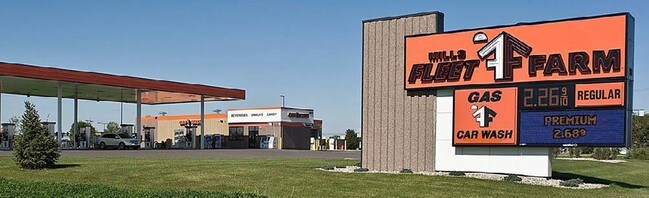
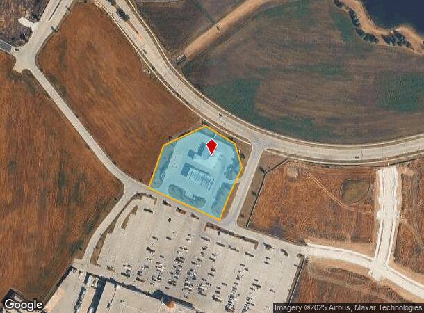
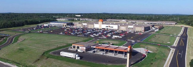
Property Record
1501 Pabst Farms Blvd, Oconomowoc, WI 53066
NEARBY LISTINGS FOR SALE OR LEASE
Property Detail
1501 Pabst Farms Blvd
Milwaukee-Waukesha-West Allis, WI
Reciprocal Easement
OCOC-0633-999-019
LOT 2 CSM #11597 VOL 116/45 REC AS DOC #4290552 PT PARCEL 6 CSM #9170 :: INCLUDING RECIPROCAL EASEMENT DESC IN DOC #4290677 CORRECTED IN DOC #4447713; PT NW1/4 SW1/4 & SE1/4 OF NE1/4 & NW1/4 & NE1/4 OF SE1/4 SEC 15 T7N R17E
Commercialnec
Waukesha
X
Wisconsin
55133C0154G
2
2024
2.13 AC
2024
NE/Delafield
204100
Milwaukee/Madison
DEMOGRAPHICS near 1501 Pabst Farms Blvd
1 Mile
3 Mile
5 Mile
2024 Total Population
2,330
16,497
46,733
2029 Population
2,547
17,520
48,601
Pop Growth 2024-2029
+ 9.31%
+ 6.20%
+ 4.00%
Average Age
45
44
44
2024 Total Households
876
6,675
18,909
HH Growth 2024-2029
+ 9.70%
+ 6.38%
+ 4.08%
Median Household Inc
$123,449
$108,985
$103,823
Avg Household Size
2.50
2.40
2.40
2024 Avg HH Vehicles
2.00
2.00
2.00
Median Home Value
$457,427
$414,587
$390,231
Median Year Built
2004
1989
1986
Nearby Places
Map Layers
Map Styles
 Street
 Aerial
- Restaurants
- Banks
- Shops
- Fitness
- Groceries
PUBLIC TRANSPORTATION
AIRPORT
General Mitchell International
DRIVE
WALK
Distance
General Mitchell International
50 min
36.1 mi
Freight Ports
Port Milwaukee
DRIVE
WALK
Distance
Port Milwaukee
43 min
32.7 mi
Nearby Properties
Address
Land Use
TOTAL SIZE
Lot Size
Zoning
Address
Land Use
TOTAL SIZE
Lot Size
Zoning
93.56 AC
Address
Land Use
TOTAL SIZE
Lot Size
Zoning
52.93 AC
Address
Land Use
TOTAL SIZE
Lot Size
Zoning
25.09 AC
Address
Land Use
TOTAL SIZE
Lot Size
Zoning
85.90 AC
Address
Land Use
TOTAL SIZE
Lot Size
Zoning
Address
Land Use
TOTAL SIZE
Lot Size
Zoning
12.32 AC
Address
Land Use
TOTAL SIZE
Lot Size
Zoning
Address
Land Use
TOTAL SIZE
Lot Size
Zoning
Address
Land Use
TOTAL SIZE
Lot Size
Zoning
12.01 AC
Address
Land Use
TOTAL SIZE
Lot Size
Zoning
Address
Land Use
TOTAL SIZE
Lot Size
Zoning
Address
Land Use
TOTAL SIZE
Lot Size
Zoning
Address
Land Use
TOTAL SIZE
Lot Size
Zoning
Address
Land Use
TOTAL SIZE
Lot Size
Zoning
8.92 AC
Address
Land Use
TOTAL SIZE
Lot Size
Zoning
Address
Land Use
TOTAL SIZE
Lot Size
Zoning
22.10 AC
Address
Land Use
TOTAL SIZE
Lot Size
Zoning
Address
Land Use
TOTAL SIZE
Lot Size
Zoning
Address
Land Use
TOTAL SIZE
Lot Size
Zoning
17.86 AC
Address
Land Use
TOTAL SIZE
Lot Size
Zoning
3.52 AC
Address
Land Use
TOTAL SIZE
Lot Size
Zoning
Address
Land Use
TOTAL SIZE
Lot Size
Zoning
Address
Land Use
TOTAL SIZE
Lot Size
Zoning
Address
Land Use
TOTAL SIZE
Lot Size
Zoning
Address
Land Use
TOTAL SIZE
Lot Size
Zoning
Address
Land Use
TOTAL SIZE
Lot Size
Zoning
Address
Land Use
TOTAL SIZE
Lot Size
Zoning
Address
Land Use
TOTAL SIZE
Lot Size
Zoning
Address
Land Use
TOTAL SIZE
Lot Size
Zoning
6.20 AC
Address
Land Use
TOTAL SIZE
Lot Size
Zoning
1.57 AC
The World's #1 Commercial Real Estate Marketplace
Connect with us
© 2025 CoStar Group
The information above has been obtained from sources believed reliable. While we do not doubt its accuracy we have not verified it and make no guarantee, warranty or representation about it. It is your responsibility to independently confirm its accuracy and completeness. Any projections, opinions, assumptions, or estimates used are for example only and do not represent the current or future performance of the property. The value of this transaction to you depends on tax and other factors which should be evaluated by your tax, financial, and legal advisors. You and your advisors should conduct a careful, independent investigation of the property to determine to your satisfaction the suitability of the property for your needs.