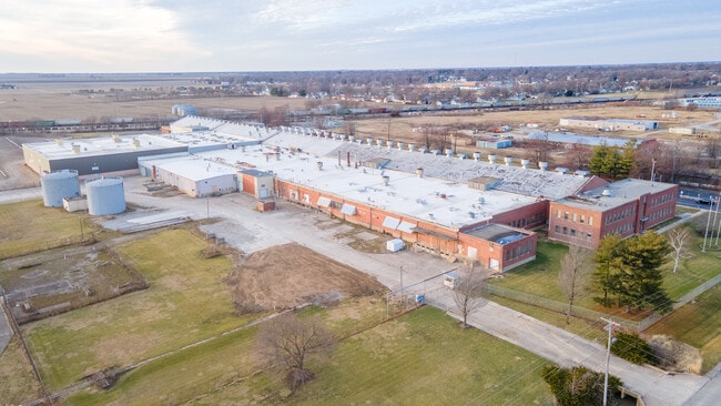
Property Record
1501 S 19Th St, Mattoon, IL 61938
Current Lease Availabilities
NEARBY LISTINGS FOR SALE OR LEASE
Property Detail
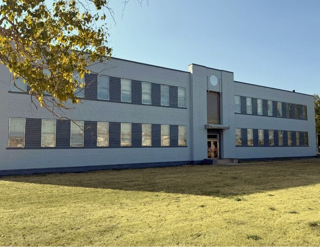
1501 S 19Th St
07-1-00846-002
PT OF SEC 23 BK 469 PG 052* PART OF G E PLANT
Industrialgeneral
Coles
X
Illinois
17029C0260D
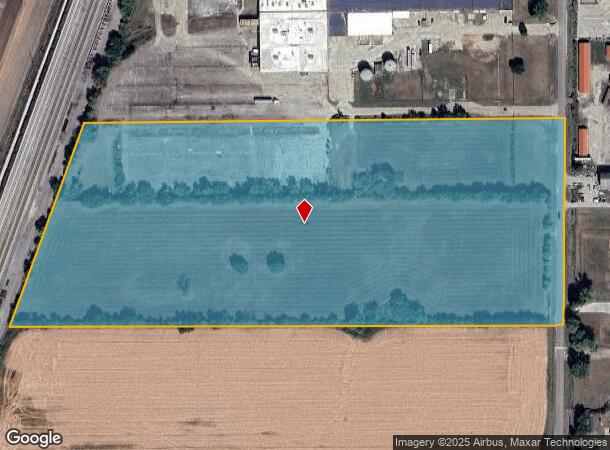
22.05 AC
2024
Effingham/Central Illinois Area
2024
Other Market Areas
001100
Charleston-Mattoon, IL
178,957 SF
DEMOGRAPHICS near 1501 S 19Th St
1 Mile
3 Mile
5 Mile
2024 Total Population
4,781
17,344
19,112
2029 Population
4,679
17,006
18,747
Pop Growth 2024-2029
(2.13%)
(1.95%)
(1.91%)
Average Age
41
42
42
2024 Total Households
2,099
7,749
8,505
HH Growth 2024-2029
(2.38%)
(2.14%)
(2.09%)
Median Household Inc
$44,869
$44,734
$45,651
Avg Household Size
2.20
2.10
2.20
2024 Avg HH Vehicles
2.00
2.00
2.00
Median Home Value
$91,284
$86,887
$91,014
Median Year Built
1957
1957
1959
Nearby Places
Map Layers
Map Styles
 Street
 Aerial
- Restaurants
- Banks
- Shops
- Fitness
- Groceries
PUBLIC TRANSPORTATION
COMMUTER RAIL
Mattoon Amtrak Station (City of New Orleans - Amtrak, Illini - Amtrak, Saluki - Amtrak)
DRIVE
WALK
Distance
Mattoon Amtrak Station (City of New Orleans - Amtrak, Illini - Amtrak, Saluki - Amtrak)
4 min
1.5 mi
Freight Ports
Port Milwaukee
DRIVE
WALK
Distance
Port Milwaukee
312 min
270.2 mi
Nearby Properties
Address
Land Use
TOTAL SIZE
Lot Size
Zoning
Address
Land Use
TOTAL SIZE
Lot Size
Zoning
199,970 SF
24.47 AC
Address
Land Use
TOTAL SIZE
Lot Size
Zoning
75,332 SF
6.48 AC
Address
Land Use
TOTAL SIZE
Lot Size
Zoning
290,500 SF
30.27 AC
Address
Land Use
TOTAL SIZE
Lot Size
Zoning
7,500 SF
26.72 AC
Address
Land Use
TOTAL SIZE
Lot Size
Zoning
0.92 AC
Address
Land Use
TOTAL SIZE
Lot Size
Zoning
4,500 SF
13.35 AC
Address
Land Use
TOTAL SIZE
Lot Size
Zoning
208,184 SF
30.37 AC
Address
Land Use
TOTAL SIZE
Lot Size
Zoning
39,960 SF
1.95 AC
Address
Land Use
TOTAL SIZE
Lot Size
Zoning
Address
Land Use
TOTAL SIZE
Lot Size
Zoning
59,782 SF
6.79 AC
Address
Land Use
TOTAL SIZE
Lot Size
Zoning
95,068 SF
10.13 AC
Address
Land Use
TOTAL SIZE
Lot Size
Zoning
3,360 SF
5.96 AC
Address
Land Use
TOTAL SIZE
Lot Size
Zoning
9,888 SF
1.17 AC
Address
Land Use
TOTAL SIZE
Lot Size
Zoning
31,026 SF
34.80 AC
Address
Land Use
TOTAL SIZE
Lot Size
Zoning
149,715 SF
56.72 AC
Address
Land Use
TOTAL SIZE
Lot Size
Zoning
41,673 SF
5.40 AC
Address
Land Use
TOTAL SIZE
Lot Size
Zoning
Address
Land Use
TOTAL SIZE
Lot Size
Zoning
2,580 SF
13.07 AC
Address
Land Use
TOTAL SIZE
Lot Size
Zoning
15,263 SF
2.80 AC
Address
Land Use
TOTAL SIZE
Lot Size
Zoning
230,400 SF
31.34 AC
Address
Land Use
TOTAL SIZE
Lot Size
Zoning
19,320 SF
1.44 AC
Address
Land Use
TOTAL SIZE
Lot Size
Zoning
38,486 SF
4.99 AC
Address
Land Use
TOTAL SIZE
Lot Size
Zoning
68,424 SF
5 AC
Address
Land Use
TOTAL SIZE
Lot Size
Zoning
25,576 SF
6.60 AC
Address
Land Use
TOTAL SIZE
Lot Size
Zoning
38,414 SF
5.21 AC
Address
Land Use
TOTAL SIZE
Lot Size
Zoning
62,944 SF
0.80 AC
Address
Land Use
TOTAL SIZE
Lot Size
Zoning
27,534 SF
0.32 AC
Address
Land Use
TOTAL SIZE
Lot Size
Zoning
5,264 SF
1.65 AC
Address
Land Use
TOTAL SIZE
Lot Size
Zoning
38,463 SF
0.32 AC
Address
Land Use
TOTAL SIZE
Lot Size
Zoning
3.50 AC
The World's #1 Commercial Real Estate Marketplace
Connect with us
© 2026 CoStar Group
The information above has been obtained from sources believed reliable. While we do not doubt its accuracy we have not verified it and make no guarantee, warranty or representation about it. It is your responsibility to independently confirm its accuracy and completeness. Any projections, opinions, assumptions, or estimates used are for example only and do not represent the current or future performance of the property. The value of this transaction to you depends on tax and other factors which should be evaluated by your tax, financial, and legal advisors. You and your advisors should conduct a careful, independent investigation of the property to determine to your satisfaction the suitability of the property for your needs.