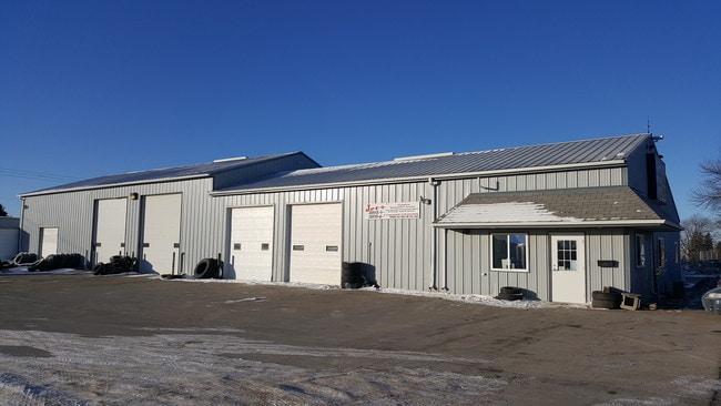
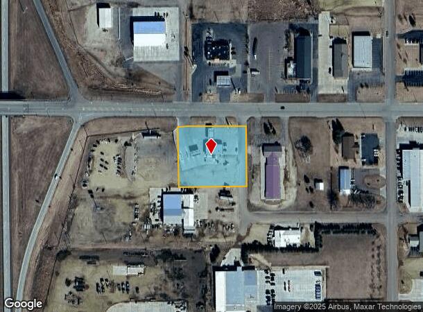
Property Record
1501 W Cedar St, Beresford, SD 57004

NEARBY LISTINGS FOR SALE OR LEASE
-
-
View all Beresford listings for sale on LoopNet.com
Property Detail
1501 W Cedar St
02.18.01.1070
Service Center Add
Commercialnec
TR 1 JET SERVICE CENTER ADD BERES CITY
X
Union
46027C0100D
South Dakota
2024
1.62 AC
2025
South Dakota Area
020100
Other Market Areas
2,720 SF
Sioux City, IA-NE-SD
DEMOGRAPHICS near 1501 W Cedar St
1 Mile
3 Mile
5 Mile
2024 Total Population
1,628
2,727
3,031
2029 Population
1,764
2,945
3,287
Pop Growth 2024-2029
+ 8.35%
+ 7.99%
+ 8.45%
Average Age
42
42
42
2024 Total Households
653
1,094
1,214
HH Growth 2024-2029
+ 8.42%
+ 8.14%
+ 8.57%
Median Household Inc
$73,545
$74,119
$74,179
Avg Household Size
2.40
2.40
2.40
2024 Avg HH Vehicles
3.00
3.00
3.00
Median Home Value
$207,143
$210,830
$214,309
Median Year Built
1964
1965
1964
Nearby Places
Map Layers
Map Styles
 Street
 Aerial
- Restaurants
- Banks
- Shops
- Fitness
- Groceries
SALE & LEASE HISTORY
LISTING DATE
SALE/LEASE

Jan 23, 2018
For Sale
Nearby Properties
Address
Land Use
TOTAL SIZE
Lot Size
Zoning
Address
Land Use
TOTAL SIZE
Lot Size
Zoning
17.37 AC
MUNICIPALI
Address
Land Use
TOTAL SIZE
Lot Size
Zoning
15.03 AC
MUNICIPALI
Address
Land Use
TOTAL SIZE
Lot Size
Zoning
24,400 SF
11.74 AC
Address
Land Use
TOTAL SIZE
Lot Size
Zoning
139,780 SF
21.06 AC
Address
Land Use
TOTAL SIZE
Lot Size
Zoning
56,010 SF
4.29 AC
Address
Land Use
TOTAL SIZE
Lot Size
Zoning
8.50 AC
MUNICIPALI
Address
Land Use
TOTAL SIZE
Lot Size
Zoning
1.72 AC
MUNICIPALI
Address
Land Use
TOTAL SIZE
Lot Size
Zoning
14.87 AC
MUNICIPALI
Address
Land Use
TOTAL SIZE
Lot Size
Zoning
2.01 AC
MUNICIPALI
Address
Land Use
TOTAL SIZE
Lot Size
Zoning
6,120 SF
6.28 AC
Address
Land Use
TOTAL SIZE
Lot Size
Zoning
16,640 SF
3.10 AC
Address
Land Use
TOTAL SIZE
Lot Size
Zoning
1.71 AC
MUNICIPALI
Address
Land Use
TOTAL SIZE
Lot Size
Zoning
10,376 SF
1.38 AC
Address
Land Use
TOTAL SIZE
Lot Size
Zoning
9.98 AC
MUNICIPALI
Address
Land Use
TOTAL SIZE
Lot Size
Zoning
4.63 AC
MUNICIPALI
Address
Land Use
TOTAL SIZE
Lot Size
Zoning
1.03 AC
MUNICIPALI
Address
Land Use
TOTAL SIZE
Lot Size
Zoning
1,288 SF
22.25 AC
Address
Land Use
TOTAL SIZE
Lot Size
Zoning
7 AC
C COMMERCI
Address
Land Use
TOTAL SIZE
Lot Size
Zoning
0.94 AC
MUNICIPALI
Address
Land Use
TOTAL SIZE
Lot Size
Zoning
2.33 AC
MUNICIPALI
Address
Land Use
TOTAL SIZE
Lot Size
Zoning
1.11 AC
MUNICIPALI
Address
Land Use
TOTAL SIZE
Lot Size
Zoning
2,202 SF
148 AC
Address
Land Use
TOTAL SIZE
Lot Size
Zoning
20,320 SF
2.85 AC
Address
Land Use
TOTAL SIZE
Lot Size
Zoning
2,464 SF
179.64 AC
Address
Land Use
TOTAL SIZE
Lot Size
Zoning
2,586 SF
80 AC
Address
Land Use
TOTAL SIZE
Lot Size
Zoning
1,800 SF
1.62 AC
Address
Land Use
TOTAL SIZE
Lot Size
Zoning
17,500 SF
5.29 AC
Address
Land Use
TOTAL SIZE
Lot Size
Zoning
1,756 SF
160 AC
Address
Land Use
TOTAL SIZE
Lot Size
Zoning
1,740 SF
33 AC
Address
Land Use
TOTAL SIZE
Lot Size
Zoning
13,860 SF
1.30 AC
The World's #1 Commercial Real Estate Marketplace
Connect with us
© 2025 CoStar Group
The information above has been obtained from sources believed reliable. While we do not doubt its accuracy we have not verified it and make no guarantee, warranty or representation about it. It is your responsibility to independently confirm its accuracy and completeness. Any projections, opinions, assumptions, or estimates used are for example only and do not represent the current or future performance of the property. The value of this transaction to you depends on tax and other factors which should be evaluated by your tax, financial, and legal advisors. You and your advisors should conduct a careful, independent investigation of the property to determine to your satisfaction the suitability of the property for your needs.