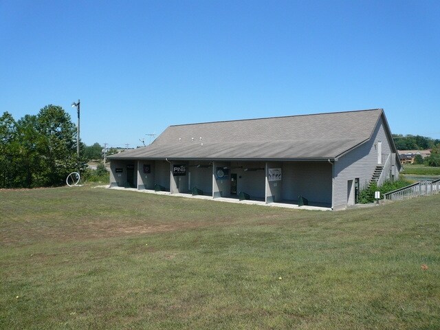
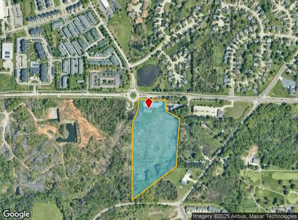
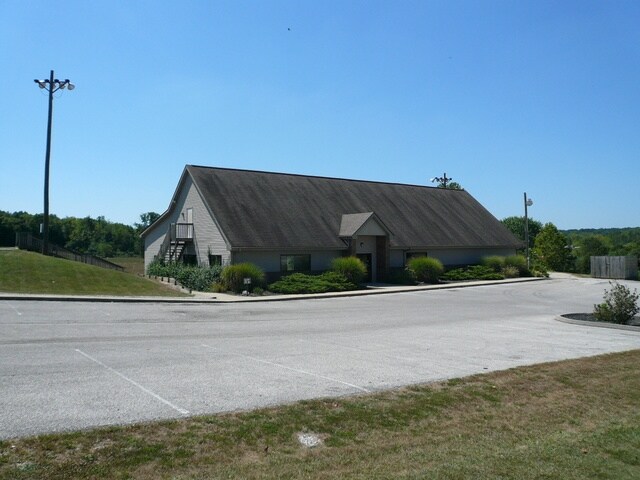
Property Record
1501 W Tapp Rd, Bloomington, IN 47403
NEARBY LISTINGS FOR SALE OR LEASE
Property Detail
1501 W Tapp Rd
Bloomington, IN
Woolery Planned Community
53-01-53-708-004.000-009
015-37080-04 WOOLERY PLANNED COMMUNITY 4TH PT LOT 4 14.18A ANNEXED 3-1-04 FROM 014-37080-04
Officebuilding
Monroe
X
Indiana
18105C0143D
4
2024
14.18 AC
2024
Bloomington/Terre Haute
001102
Other Market Areas
4,200 SF
DEMOGRAPHICS near 1501 W Tapp Rd
1 Mile
3 Mile
5 Mile
2024 Total Population
6,172
57,589
103,288
2029 Population
6,120
57,320
102,890
Pop Growth 2024-2029
(0.84%)
(0.47%)
(0.39%)
Average Age
36
36
35
2024 Total Households
2,737
26,607
43,673
HH Growth 2024-2029
(0.84%)
(0.52%)
(0.42%)
Median Household Inc
$63,727
$45,678
$45,104
Avg Household Size
2.10
2.10
2.10
2024 Avg HH Vehicles
2.00
2.00
2.00
Median Home Value
$191,335
$218,180
$242,345
Median Year Built
2000
1986
1986
Nearby Places
Map Layers
Map Styles
 Street
 Aerial
- Restaurants
- Banks
- Shops
- Fitness
- Groceries
Nearby Properties
Address
Land Use
TOTAL SIZE
Lot Size
Zoning
Address
Land Use
TOTAL SIZE
Lot Size
Zoning
442,250 SF
37.15 AC
Address
Land Use
TOTAL SIZE
Lot Size
Zoning
496,556 SF
1.73 AC
Address
Land Use
TOTAL SIZE
Lot Size
Zoning
10,573 SF
3.28 AC
Address
Land Use
TOTAL SIZE
Lot Size
Zoning
35,777 SF
11.68 AC
Address
Land Use
TOTAL SIZE
Lot Size
Zoning
19,128 SF
24.44 AC
Address
Land Use
TOTAL SIZE
Lot Size
Zoning
60,434 SF
29.85 AC
IG
Address
Land Use
TOTAL SIZE
Lot Size
Zoning
169,170 SF
0.72 AC
Address
Land Use
TOTAL SIZE
Lot Size
Zoning
3,934 SF
21.23 AC
Address
Land Use
TOTAL SIZE
Lot Size
Zoning
8,190 SF
4.22 AC
Address
Land Use
TOTAL SIZE
Lot Size
Zoning
64,687 SF
9.96 AC
Address
Land Use
TOTAL SIZE
Lot Size
Zoning
134,566 SF
0.60 AC
Address
Land Use
TOTAL SIZE
Lot Size
Zoning
7,500 SF
0.40 AC
Address
Land Use
TOTAL SIZE
Lot Size
Zoning
181,798 SF
0.80 AC
Address
Land Use
TOTAL SIZE
Lot Size
Zoning
32,737 SF
0.93 AC
Address
Land Use
TOTAL SIZE
Lot Size
Zoning
18,772 SF
2.69 AC
Address
Land Use
TOTAL SIZE
Lot Size
Zoning
17,312 SF
31.90 AC
Address
Land Use
TOTAL SIZE
Lot Size
Zoning
14,376 SF
11.03 AC
Address
Land Use
TOTAL SIZE
Lot Size
Zoning
576 SF
13 AC
Address
Land Use
TOTAL SIZE
Lot Size
Zoning
1,986 SF
3.28 AC
Address
Land Use
TOTAL SIZE
Lot Size
Zoning
1,120 SF
11.95 AC
Address
Land Use
TOTAL SIZE
Lot Size
Zoning
87,842 SF
11.14 AC
GB
Address
Land Use
TOTAL SIZE
Lot Size
Zoning
19,623 SF
8.21 AC
Address
Land Use
TOTAL SIZE
Lot Size
Zoning
10,573 SF
1.30 AC
Address
Land Use
TOTAL SIZE
Lot Size
Zoning
78,474 SF
0.35 AC
Address
Land Use
TOTAL SIZE
Lot Size
Zoning
119,952 SF
0.82 AC
Address
Land Use
TOTAL SIZE
Lot Size
Zoning
6,120 SF
36.03 AC
Address
Land Use
TOTAL SIZE
Lot Size
Zoning
17,950 SF
12.06 AC
Address
Land Use
TOTAL SIZE
Lot Size
Zoning
218,783 SF
24.97 AC
GB
Address
Land Use
TOTAL SIZE
Lot Size
Zoning
11,488 SF
14.33 AC
Address
Land Use
TOTAL SIZE
Lot Size
Zoning
48,022 SF
0.77 AC
The World's #1 Commercial Real Estate Marketplace
Connect with us
© 2025 CoStar Group
The information above has been obtained from sources believed reliable. While we do not doubt its accuracy we have not verified it and make no guarantee, warranty or representation about it. It is your responsibility to independently confirm its accuracy and completeness. Any projections, opinions, assumptions, or estimates used are for example only and do not represent the current or future performance of the property. The value of this transaction to you depends on tax and other factors which should be evaluated by your tax, financial, and legal advisors. You and your advisors should conduct a careful, independent investigation of the property to determine to your satisfaction the suitability of the property for your needs.