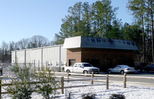
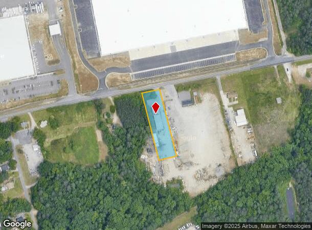
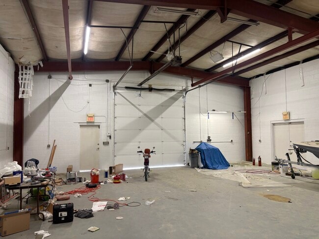
Property Record
1501 Willis Rd, North Chesterfield, VA 23237

Current Lease Availabilities
NEARBY LISTINGS FOR SALE OR LEASE
Property Detail
1501 Willis Rd
Richmond, VA
Gravel Pit Farms
799-67-23-62-500-000
GRAVEL PIT FARMS L PT TR 12A
Multipleuses
Chesterfield
X
Virginia
5101290100E
12a
2025
0.95 AC
2025
Jeff Davis Corridor
100403
Richmond VA
5,600 SF
DEMOGRAPHICS near 1501 Willis Rd
1 Mile
3 Mile
5 Mile
2024 Total Population
508
20,675
82,797
2029 Population
546
22,687
90,080
Pop Growth 2024-2029
+ 7.48%
+ 9.73%
+ 8.80%
Average Age
36
39
39
2024 Total Households
216
7,992
30,906
HH Growth 2024-2029
+ 7.41%
+ 9.85%
+ 8.89%
Median Household Inc
$72,812
$58,166
$67,077
Avg Household Size
2.30
2.50
2.60
2024 Avg HH Vehicles
2.00
2.00
2.00
Median Home Value
$93,938
$245,494
$258,790
Median Year Built
1997
1984
1985
Nearby Places
- Restaurants
- Banks
- Shops
- Fitness
- Groceries
PUBLIC TRANSPORTATION
AIRPORT
Richmond International
DRIVE
WALK
Distance
Richmond International
24 min
14.6 mi
Nearby Properties
Address
Land Use
TOTAL SIZE
Lot Size
Zoning
Address
Land Use
TOTAL SIZE
Lot Size
Zoning
100 SF
652.52 AC
A - AGRICU
Address
Land Use
TOTAL SIZE
Lot Size
Zoning
437,024 SF
39.40 AC
I3 - HVY I
Address
Land Use
TOTAL SIZE
Lot Size
Zoning
406,110 SF
57.69 AC
I3 - HVY I
Address
Land Use
TOTAL SIZE
Lot Size
Zoning
100 SF
36.88 AC
RMF - RES,
Address
Land Use
TOTAL SIZE
Lot Size
Zoning
177,908 SF
13.59 AC
RMF - RES,
Address
Land Use
TOTAL SIZE
Lot Size
Zoning
320,853 SF
33.68 AC
I3 - HVY I
Address
Land Use
TOTAL SIZE
Lot Size
Zoning
220,825 SF
55.17 AC
I3 - HVY I
Address
Land Use
TOTAL SIZE
Lot Size
Zoning
55,952 SF
11.82 AC
C3 - COMMU
Address
Land Use
TOTAL SIZE
Lot Size
Zoning
406,490 SF
19.58 AC
I3 - HVY I
Address
Land Use
TOTAL SIZE
Lot Size
Zoning
406,490 SF
33.22 AC
I3 - HVY I
Address
Land Use
TOTAL SIZE
Lot Size
Zoning
67,060 SF
4.93 AC
C5 - GEN B
Address
Land Use
TOTAL SIZE
Lot Size
Zoning
23,586 SF
41.23 AC
I2 - GEN I
Address
Land Use
TOTAL SIZE
Lot Size
Zoning
100 SF
15.43 AC
RMF - RES,
Address
Land Use
TOTAL SIZE
Lot Size
Zoning
318,611 SF
24.17 AC
I3 - HVY I
Address
Land Use
TOTAL SIZE
Lot Size
Zoning
138,860 SF
23.68 AC
RMF - RES,
Address
Land Use
TOTAL SIZE
Lot Size
Zoning
324,530 SF
31.47 AC
I3 - HVY I
Address
Land Use
TOTAL SIZE
Lot Size
Zoning
53,655 SF
19.01 AC
C3 - COMMU
Address
Land Use
TOTAL SIZE
Lot Size
Zoning
24,929 SF
6.03 AC
C3 - COMMU
Address
Land Use
TOTAL SIZE
Lot Size
Zoning
161,915 SF
21.43 AC
I3 - HVY I
Address
Land Use
TOTAL SIZE
Lot Size
Zoning
133,039 SF
10.40 AC
I3 - HVY I
Address
Land Use
TOTAL SIZE
Lot Size
Zoning
159,722 SF
85.50 AC
I3 - HVY I
Address
Land Use
TOTAL SIZE
Lot Size
Zoning
80,000 SF
3.26 AC
C5 - GEN B
Address
Land Use
TOTAL SIZE
Lot Size
Zoning
506 SF
42.94 AC
I3 - HVY I
Address
Land Use
TOTAL SIZE
Lot Size
Zoning
287 SF
57.15 AC
I3 - HVY I
Address
Land Use
TOTAL SIZE
Lot Size
Zoning
46,140 SF
5 AC
C5 - GEN B
Address
Land Use
TOTAL SIZE
Lot Size
Zoning
5,775 SF
59.60 AC
I3 - HVY I
Address
Land Use
TOTAL SIZE
Lot Size
Zoning
240 SF
28.09 AC
I3 - HVY I
Address
Land Use
TOTAL SIZE
Lot Size
Zoning
74,575 SF
15.49 AC
I1 - LT IN
Address
Land Use
TOTAL SIZE
Lot Size
Zoning
45,124 SF
44.79 AC
I3 - HVY I
Address
Land Use
TOTAL SIZE
Lot Size
Zoning
8,400 SF
281.55 AC
I3 - HVY I
The World's #1 Commercial Real Estate Marketplace
Connect with us
© 2025 CoStar Group
The information above has been obtained from sources believed reliable. While we do not doubt its accuracy we have not verified it and make no guarantee, warranty or representation about it. It is your responsibility to independently confirm its accuracy and completeness. Any projections, opinions, assumptions, or estimates used are for example only and do not represent the current or future performance of the property. The value of this transaction to you depends on tax and other factors which should be evaluated by your tax, financial, and legal advisors. You and your advisors should conduct a careful, independent investigation of the property to determine to your satisfaction the suitability of the property for your needs.