Property Record
15015 Garrett Rd, Houston, TX 77044


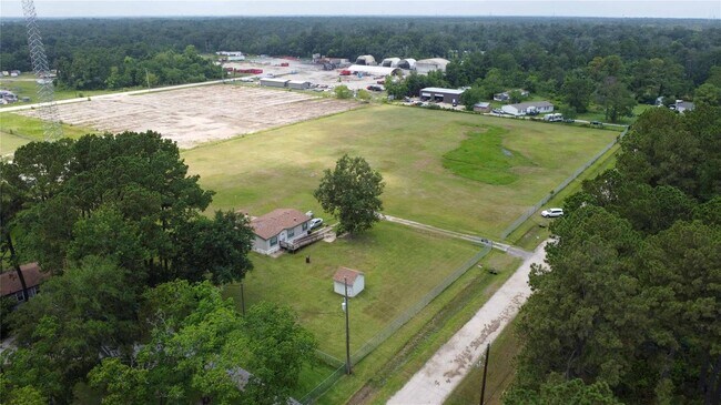

This Property Is For Sale
NEARBY LISTINGS FOR SALE OR LEASE
Property Detail
15015 Garrett Rd
Houston-The Woodlands-Sugar Land, TX
Lincoln Park Farms
0502050000130
Harris
Mobilemanufacturedhomeregardlessoflandownership
Texas
X
4.87 AC
48201C0520L
Northeast Outlier
154 SF
Houston
DEMOGRAPHICS near 15015 Garrett Rd
1 Mile
3 Mile
5 Mile
2024 Total Population
1,976
12,313
78,330
2029 Population
2,040
12,464
80,568
Pop Growth 2024-2029
+ 3.24%
+ 1.23%
+ 2.86%
Average Age
33
33
33
2024 Total Households
583
3,766
23,986
HH Growth 2024-2029
+ 3.26%
+ 1.12%
+ 2.80%
Median Household Inc
$57,784
$78,448
$74,510
Avg Household Size
3.40
3.30
3.20
2024 Avg HH Vehicles
2.00
2.00
2.00
Median Home Value
$218,984
$241,226
$212,473
Median Year Built
2010
2007
2006
Nearby Places
Map Layers
Map Styles
 Street
 Aerial
- Restaurants
- Banks
- Shops
- Fitness
- Groceries
PUBLIC TRANSPORTATION
AIRPORT
George Bush Intcntl/Houston
DRIVE
WALK
Distance
George Bush Intcntl/Houston
23 min
17.3 mi
William P Hobby
DRIVE
WALK
Distance
William P Hobby
42 min
25.3 mi
Freight Ports
Port of Houston
DRIVE
WALK
Distance
Port of Houston
29 min
17.3 mi
Nearby Properties
Address
Land Use
TOTAL SIZE
Lot Size
Zoning
Address
Land Use
TOTAL SIZE
Lot Size
Zoning
1,421,980 SF
147.83 AC
Address
Land Use
TOTAL SIZE
Lot Size
Zoning
1,793.99 AC
Address
Land Use
TOTAL SIZE
Lot Size
Zoning
Address
Land Use
TOTAL SIZE
Lot Size
Zoning
434,978 SF
37.08 AC
Address
Land Use
TOTAL SIZE
Lot Size
Zoning
430,841 SF
193.79 AC
Address
Land Use
TOTAL SIZE
Lot Size
Zoning
5.68 AC
Address
Land Use
TOTAL SIZE
Lot Size
Zoning
315,000 SF
21.47 AC
Address
Land Use
TOTAL SIZE
Lot Size
Zoning
824,156 SF
53.31 AC
Address
Land Use
TOTAL SIZE
Lot Size
Zoning
168,348 SF
108.41 AC
Address
Land Use
TOTAL SIZE
Lot Size
Zoning
260,792 SF
206.39 AC
Address
Land Use
TOTAL SIZE
Lot Size
Zoning
131,500 SF
6.22 AC
Address
Land Use
TOTAL SIZE
Lot Size
Zoning
634,459 SF
469.92 AC
Address
Land Use
TOTAL SIZE
Lot Size
Zoning
188,510 SF
80.78 AC
Address
Land Use
TOTAL SIZE
Lot Size
Zoning
239,419 SF
33 AC
Address
Land Use
TOTAL SIZE
Lot Size
Zoning
66,450 SF
18 AC
Address
Land Use
TOTAL SIZE
Lot Size
Zoning
252,516 SF
74.53 AC
Address
Land Use
TOTAL SIZE
Lot Size
Zoning
124,140 SF
9.29 AC
Address
Land Use
TOTAL SIZE
Lot Size
Zoning
116,965 SF
28.06 AC
Address
Land Use
TOTAL SIZE
Lot Size
Zoning
139,752 SF
20.41 AC
Address
Land Use
TOTAL SIZE
Lot Size
Zoning
98,733 SF
7.94 AC
Address
Land Use
TOTAL SIZE
Lot Size
Zoning
135,354 SF
40 AC
Address
Land Use
TOTAL SIZE
Lot Size
Zoning
67,200 SF
8.49 AC
Address
Land Use
TOTAL SIZE
Lot Size
Zoning
77,254 SF
44.01 AC
Address
Land Use
TOTAL SIZE
Lot Size
Zoning
81.08 AC
Address
Land Use
TOTAL SIZE
Lot Size
Zoning
112,872 SF
49.10 AC
Address
Land Use
TOTAL SIZE
Lot Size
Zoning
194.65 AC
Address
Land Use
TOTAL SIZE
Lot Size
Zoning
23,840 SF
103.67 AC
Address
Land Use
TOTAL SIZE
Lot Size
Zoning
90,645 SF
42.60 AC
Address
Land Use
TOTAL SIZE
Lot Size
Zoning
83,695 SF
17.55 AC
Address
Land Use
TOTAL SIZE
Lot Size
Zoning
66,500 SF
15.16 AC
The World's #1 Commercial Real Estate Marketplace
Connect with us
© 2025 CoStar Group
The information above has been obtained from sources believed reliable. While we do not doubt its accuracy we have not verified it and make no guarantee, warranty or representation about it. It is your responsibility to independently confirm its accuracy and completeness. Any projections, opinions, assumptions, or estimates used are for example only and do not represent the current or future performance of the property. The value of this transaction to you depends on tax and other factors which should be evaluated by your tax, financial, and legal advisors. You and your advisors should conduct a careful, independent investigation of the property to determine to your satisfaction the suitability of the property for your needs.