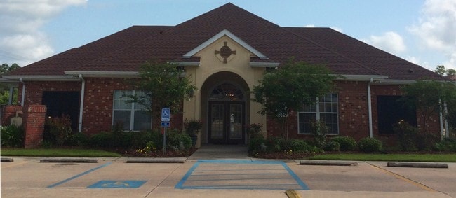
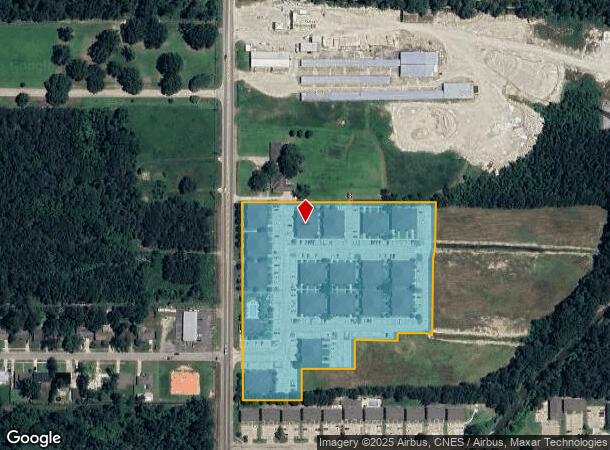
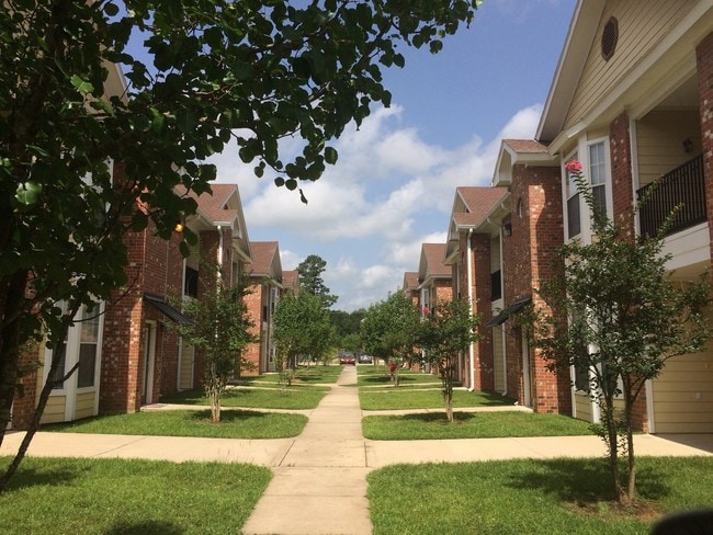
Property Record
15015 N Creeks Rd, Hammond, LA 70401
NEARBY LISTINGS FOR SALE OR LEASE
-
-
View all Hammond listings for sale on LoopNet.com
Property Detail
15015 N Creeks Rd
06161391
8.136A IN S12 OF SW14 OF NW14 OF SEC 14 T6SR7E BEING THE CREEKS APTS PH I B979 P217-220 B995 P781 B1018 P764-766-768 B1275 P2
Apartment
Tangipahoa
AE
Louisiana
22105C0340F
8.14 AC
2024
Louisiana South Area
2024
Other Market Areas
954001
Hammond, LA
4,664 SF
DEMOGRAPHICS near 15015 N Creeks Rd
1 Mile
3 Mile
5 Mile
2024 Total Population
5,095
28,971
54,387
2029 Population
5,512
31,346
58,882
Pop Growth 2024-2029
+ 8.18%
+ 8.20%
+ 8.26%
Average Age
32
35
36
2024 Total Households
1,975
11,017
21,080
HH Growth 2024-2029
+ 8.35%
+ 8.31%
+ 8.33%
Median Household Inc
$38,959
$41,684
$46,443
Avg Household Size
2.20
2.30
2.40
2024 Avg HH Vehicles
1.00
2.00
2.00
Median Home Value
$185,764
$184,986
$190,333
Median Year Built
1985
1985
1990
Nearby Places
Map Layers
Map Styles
 Street
 Aerial
- Restaurants
- Banks
- Shops
- Fitness
- Groceries
PUBLIC TRANSPORTATION
COMMUTER RAIL
Hammond Amtrak Station (City of New Orleans - Amtrak)
DRIVE
WALK
Distance
Hammond Amtrak Station (City of New Orleans - Amtrak)
5 min
2.6 mi
Freight Ports
Port of Greater Baton Rouge
DRIVE
WALK
Distance
Port of Greater Baton Rouge
62 min
50.5 mi
Nearby Properties
Address
Land Use
TOTAL SIZE
Lot Size
Zoning
Address
Land Use
TOTAL SIZE
Lot Size
Zoning
Address
Land Use
TOTAL SIZE
Lot Size
Zoning
491,200 SF
67.96 AC
Address
Land Use
TOTAL SIZE
Lot Size
Zoning
154,391 SF
12.30 AC
Address
Land Use
TOTAL SIZE
Lot Size
Zoning
1.74 AC
Address
Land Use
TOTAL SIZE
Lot Size
Zoning
126,240 SF
17.06 AC
Address
Land Use
TOTAL SIZE
Lot Size
Zoning
57,600 SF
2.07 AC
Address
Land Use
TOTAL SIZE
Lot Size
Zoning
1.56 AC
Address
Land Use
TOTAL SIZE
Lot Size
Zoning
0.89 AC
Address
Land Use
TOTAL SIZE
Lot Size
Zoning
147.07 AC
Address
Land Use
TOTAL SIZE
Lot Size
Zoning
199,026 SF
33 AC
Address
Land Use
TOTAL SIZE
Lot Size
Zoning
135,524 SF
31.08 AC
Address
Land Use
TOTAL SIZE
Lot Size
Zoning
80,506 SF
13.56 AC
Address
Land Use
TOTAL SIZE
Lot Size
Zoning
96,994 SF
4.21 AC
Address
Land Use
TOTAL SIZE
Lot Size
Zoning
19,624 SF
4.66 AC
Address
Land Use
TOTAL SIZE
Lot Size
Zoning
864 SF
0.51 AC
Address
Land Use
TOTAL SIZE
Lot Size
Zoning
19,845 SF
10 AC
Address
Land Use
TOTAL SIZE
Lot Size
Zoning
1.99 AC
Address
Land Use
TOTAL SIZE
Lot Size
Zoning
84,150 SF
5.47 AC
Address
Land Use
TOTAL SIZE
Lot Size
Zoning
14,738 SF
2.02 AC
Address
Land Use
TOTAL SIZE
Lot Size
Zoning
28,098 SF
4.61 AC
Address
Land Use
TOTAL SIZE
Lot Size
Zoning
104,140 SF
7.20 AC
Address
Land Use
TOTAL SIZE
Lot Size
Zoning
13,670 SF
5.95 AC
Address
Land Use
TOTAL SIZE
Lot Size
Zoning
49,410 SF
2.48 AC
Address
Land Use
TOTAL SIZE
Lot Size
Zoning
15,636 SF
5.15 AC
Address
Land Use
TOTAL SIZE
Lot Size
Zoning
21,450 SF
12 AC
Address
Land Use
TOTAL SIZE
Lot Size
Zoning
45.86 AC
Address
Land Use
TOTAL SIZE
Lot Size
Zoning
33,506 SF
4.20 AC
Address
Land Use
TOTAL SIZE
Lot Size
Zoning
22,062 SF
2.89 AC
Address
Land Use
TOTAL SIZE
Lot Size
Zoning
45,069 SF
4.43 AC
The World's #1 Commercial Real Estate Marketplace
Connect with us
© 2025 CoStar Group
The information above has been obtained from sources believed reliable. While we do not doubt its accuracy we have not verified it and make no guarantee, warranty or representation about it. It is your responsibility to independently confirm its accuracy and completeness. Any projections, opinions, assumptions, or estimates used are for example only and do not represent the current or future performance of the property. The value of this transaction to you depends on tax and other factors which should be evaluated by your tax, financial, and legal advisors. You and your advisors should conduct a careful, independent investigation of the property to determine to your satisfaction the suitability of the property for your needs.