Property Record
1502 Gentry St, Kansas City, MO 64116

Current Lease Availabilities
NEARBY LISTINGS FOR SALE OR LEASE
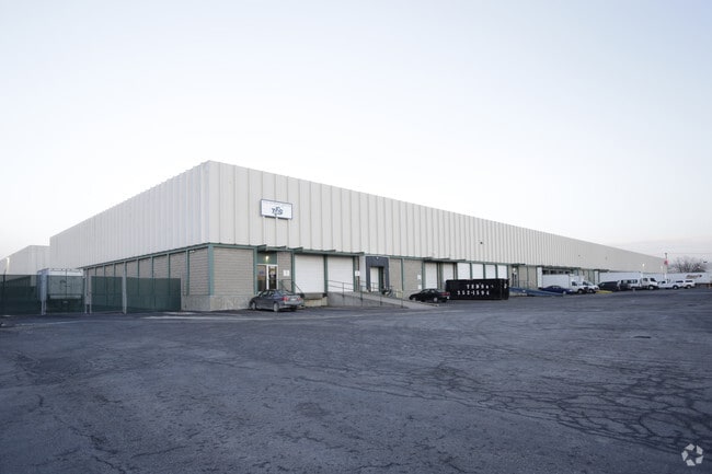
Property Detail
1502 Gentry St
Kansas City, MO-KS
Lowell Place
17-614-00-07-010.00
LOWELL PLACE LTS 1-48 BLK 10, ALL VAC ALLEY BLK 10, E1/2 VAC FAYETTE ST ADJ WEST, N1/2 VAC E 15TH AVE ADJ SOUTH & W1/2 VAC GENTRY ST ADJ EAST
Commercialnec
Clay
ARE
Missouri
29095C0139G
1-48
2024
4.94 AC
2025
City of North KC
022100
Kansas City
DEMOGRAPHICS near 1502 Gentry St
1 Mile
3 Mile
5 Mile
2024 Total Population
3,861
60,140
206,938
2029 Population
4,078
61,938
212,226
Pop Growth 2024-2029
+ 5.62%
+ 2.99%
+ 2.56%
Average Age
43
37
37
2024 Total Households
2,269
28,381
85,340
HH Growth 2024-2029
+ 5.51%
+ 3.16%
+ 2.83%
Median Household Inc
$40,293
$52,237
$49,576
Avg Household Size
1.70
2.00
2.30
2024 Avg HH Vehicles
1.00
1.00
2.00
Median Home Value
$215,894
$181,790
$149,419
Median Year Built
1986
1965
1960
Nearby Places
Map Layers
Map Styles
 Street
 Aerial
- Restaurants
- Banks
- Shops
- Fitness
- Groceries
PUBLIC TRANSPORTATION
COMMUTER RAIL
DRIVE
WALK
Distance
11 min
5.2 mi
AIRPORT
Kansas City International
DRIVE
WALK
Distance
Kansas City International
25 min
16.9 mi
Nearby Properties
Address
Land Use
TOTAL SIZE
Lot Size
Zoning
Address
Land Use
TOTAL SIZE
Lot Size
Zoning
Address
Land Use
TOTAL SIZE
Lot Size
Zoning
172,810 SF
Address
Land Use
TOTAL SIZE
Lot Size
Zoning
488,351 SF
8.34 AC
Address
Land Use
TOTAL SIZE
Lot Size
Zoning
132,304 SF
3.72 AC
KCD
Address
Land Use
TOTAL SIZE
Lot Size
Zoning
8.29 AC
Address
Land Use
TOTAL SIZE
Lot Size
Zoning
846,143 SF
51.25 AC
Address
Land Use
TOTAL SIZE
Lot Size
Zoning
63,748 SF
3.92 AC
Address
Land Use
TOTAL SIZE
Lot Size
Zoning
404,524 SF
5.51 AC
Address
Land Use
TOTAL SIZE
Lot Size
Zoning
215,920 SF
38.28 AC
Address
Land Use
TOTAL SIZE
Lot Size
Zoning
277,042 SF
0.40 AC
Address
Land Use
TOTAL SIZE
Lot Size
Zoning
277,267 SF
4.18 AC
KCD
Address
Land Use
TOTAL SIZE
Lot Size
Zoning
81,578 SF
1.63 AC
Address
Land Use
TOTAL SIZE
Lot Size
Zoning
115,627 SF
1.56 AC
Address
Land Use
TOTAL SIZE
Lot Size
Zoning
261,570 SF
1.82 AC
Address
Land Use
TOTAL SIZE
Lot Size
Zoning
Address
Land Use
TOTAL SIZE
Lot Size
Zoning
157,488 SF
1.60 AC
Address
Land Use
TOTAL SIZE
Lot Size
Zoning
87,294 SF
0.70 AC
Address
Land Use
TOTAL SIZE
Lot Size
Zoning
384,543 SF
5.40 AC
Address
Land Use
TOTAL SIZE
Lot Size
Zoning
342,989 SF
1.84 AC
Address
Land Use
TOTAL SIZE
Lot Size
Zoning
4,012,734 SF
574.30 AC
KM3
Address
Land Use
TOTAL SIZE
Lot Size
Zoning
238,003 SF
1.74 AC
Address
Land Use
TOTAL SIZE
Lot Size
Zoning
131,115 SF
2.80 AC
Address
Land Use
TOTAL SIZE
Lot Size
Zoning
Address
Land Use
TOTAL SIZE
Lot Size
Zoning
50,504 SF
0.39 AC
Address
Land Use
TOTAL SIZE
Lot Size
Zoning
90,023 SF
1.18 AC
Address
Land Use
TOTAL SIZE
Lot Size
Zoning
99,060 SF
0.99 AC
Address
Land Use
TOTAL SIZE
Lot Size
Zoning
296,548 SF
5.09 AC
Address
Land Use
TOTAL SIZE
Lot Size
Zoning
276,233 SF
Address
Land Use
TOTAL SIZE
Lot Size
Zoning
116,228 SF
0.79 AC
Address
Land Use
TOTAL SIZE
Lot Size
Zoning
10.97 AC
The World's #1 Commercial Real Estate Marketplace
Connect with us
© 2025 CoStar Group
The information above has been obtained from sources believed reliable. While we do not doubt its accuracy we have not verified it and make no guarantee, warranty or representation about it. It is your responsibility to independently confirm its accuracy and completeness. Any projections, opinions, assumptions, or estimates used are for example only and do not represent the current or future performance of the property. The value of this transaction to you depends on tax and other factors which should be evaluated by your tax, financial, and legal advisors. You and your advisors should conduct a careful, independent investigation of the property to determine to your satisfaction the suitability of the property for your needs.