Property Record
1502 Burrows Ct, Anacortes, WA 98221
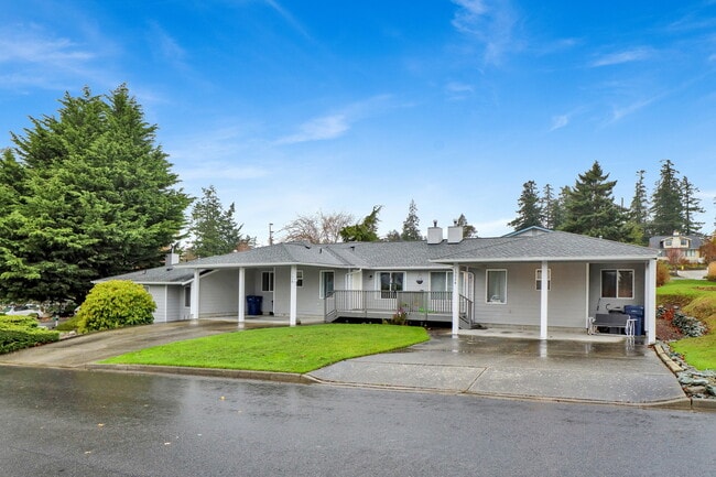
This Property Is For Sale
NEARBY LISTINGS FOR SALE OR LEASE
-
-
View all Anacortes listings for sale on LoopNet.com
Property Detail
1502 Burrows Ct
Mount Vernon-Anacortes, WA
Skyline No 16
P77809
LOT 1, SKYLINE NO. 16, ACCORDING TO THE PLAT THEREOF, RECORDED IN VOLUME 10 OF PLATS, PAGES 23 TO 25, RECORDS OF SKAGIT COUNTY, WASHINGTON.
Triplex
Skagit
X
Washington
53055C0475C
1
2025
0.21 AC
2025
Bellingham/Northwest
940201
Other Market Areas
2,416 SF
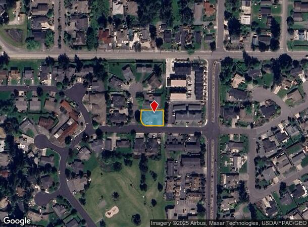
DEMOGRAPHICS near 1502 Burrows Ct
1 mile
3 mile
5 mile
2024 Total Population
3,387
11,978
21,428
2029 Population
3,506
12,313
22,022
Pop Growth 2024-2029
+ 3.51%
+ 2.80%
+ 2.77%
Average Age
54
49
48
2024 Total Households
1,572
5,209
9,515
HH Growth 2024-2029
+ 3.56%
+ 2.86%
+ 2.80%
Median Household Inc
$109,602
$113,217
$99,171
Avg Household Size
2.10
2.30
2.20
2024 Avg HH Vehicles
2.00
2.00
2.00
Median Home Value
$794,596
$772,050
$763,254
Median Year Built
1995
1994
1990
Nearby Places
Map Layers
Map Styles
 Street
 Aerial
Transit
 Traffic
 Biking
Places
Listings with unknown addresses are not visible on the map
- Restaurants
- Banks
- Shops
- Fitness
- Groceries
PUBLIC TRANSPORTATION
AIRPORT
Bellingham International
Drive
Walk
Distance
Bellingham International
69 min
48.4 mi
Freight Ports
Port of Anacortes
Drive
Walk
Distance
Port of Anacortes
11 min
4.4 mi
Nearby Properties
Address
Land Use
TOTAL SIZE
Lot Size
Zoning
Address
Land Use
TOTAL SIZE
Lot Size
Zoning
Address
Land Use
TOTAL SIZE
Lot Size
Zoning
2,236 SF
47.50 AC
Address
Land Use
TOTAL SIZE
Lot Size
Zoning
3,827 SF
114.22 AC
Address
Land Use
TOTAL SIZE
Lot Size
Zoning
Address
Land Use
TOTAL SIZE
Lot Size
Zoning
29,864 SF
0.73 AC
Address
Land Use
TOTAL SIZE
Lot Size
Zoning
25,483 SF
1.62 AC
Address
Land Use
TOTAL SIZE
Lot Size
Zoning
Address
Land Use
TOTAL SIZE
Lot Size
Zoning
8,538 SF
1 AC
Address
Land Use
TOTAL SIZE
Lot Size
Zoning
9,120 SF
0.64 AC
Address
Land Use
TOTAL SIZE
Lot Size
Zoning
56,590 SF
1.81 AC
Address
Land Use
TOTAL SIZE
Lot Size
Zoning
864 SF
0.92 AC
Address
Land Use
TOTAL SIZE
Lot Size
Zoning
14,500 SF
6.80 AC
Address
Land Use
TOTAL SIZE
Lot Size
Zoning
12,505 SF
11.68 AC
Address
Land Use
TOTAL SIZE
Lot Size
Zoning
3,650 SF
0.90 AC
Address
Land Use
TOTAL SIZE
Lot Size
Zoning
15,505 SF
2.06 AC
Address
Land Use
TOTAL SIZE
Lot Size
Zoning
108,318 SF
6.59 AC
Address
Land Use
TOTAL SIZE
Lot Size
Zoning
5,344 SF
1.15 AC
Address
Land Use
TOTAL SIZE
Lot Size
Zoning
7,345 SF
0.40 AC
Address
Land Use
TOTAL SIZE
Lot Size
Zoning
8,711 SF
0.50 AC
Address
Land Use
TOTAL SIZE
Lot Size
Zoning
8,356 SF
1.49 AC
Address
Land Use
TOTAL SIZE
Lot Size
Zoning
7,008 SF
0.40 AC
Address
Land Use
TOTAL SIZE
Lot Size
Zoning
5,307 SF
0.30 AC
Address
Land Use
TOTAL SIZE
Lot Size
Zoning
7,990 SF
0.38 AC
Address
Land Use
TOTAL SIZE
Lot Size
Zoning
6,662 SF
0.90 AC
Address
Land Use
TOTAL SIZE
Lot Size
Zoning
7,005 SF
10.30 AC
Address
Land Use
TOTAL SIZE
Lot Size
Zoning
4,838 SF
1.10 AC
Address
Land Use
TOTAL SIZE
Lot Size
Zoning
1,680 SF
4.78 AC
Address
Land Use
TOTAL SIZE
Lot Size
Zoning
5,279 SF
0.69 AC
Address
Land Use
TOTAL SIZE
Lot Size
Zoning
6,030 SF
0.72 AC
Address
Land Use
TOTAL SIZE
Lot Size
Zoning
4,344 SF
3.30 AC
The World's #1 Commercial Real Estate Marketplace
Connect with us
© 2026 CoStar Group
The information above has been obtained from sources believed reliable. While we do not doubt its accuracy we have not verified it and make no guarantee, warranty or representation about it. It is your responsibility to independently confirm its accuracy and completeness. Any projections, opinions, assumptions, or estimates used are for example only and do not represent the current or future performance of the property. The value of this transaction to you depends on tax and other factors which should be evaluated by your tax, financial, and legal advisors. You and your advisors should conduct a careful, independent investigation of the property to determine to your satisfaction the suitability of the property for your needs.