Property Record
1502 Gunbarrel Rd, Chattanooga, TN 37421
NEARBY LISTINGS FOR SALE OR LEASE
Property Detail
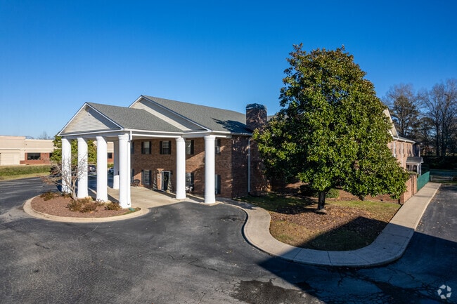
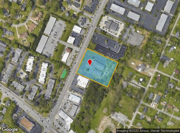
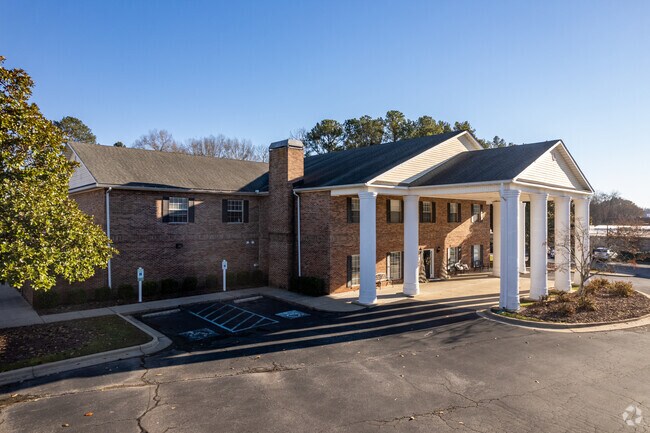
1502 Gunbarrel Rd
Chattanooga, TN-GA
The Estate At Hamilton Place Mall
158E-D-011
LT 1 THE ESTATE AT HAMILTON PLACE MALL PB57 PG116
Retirementnursinghomecombined
Hamilton
X
Tennessee
47065C0368G
1
2024
2.42 AC
2024
Outlying Chattanooga
011321
Chattanooga
32,784 SF
DEMOGRAPHICS near 1502 Gunbarrel Rd
1 Mile
3 Mile
5 Mile
2024 Total Population
8,473
46,381
112,525
2029 Population
9,057
49,221
119,183
Pop Growth 2024-2029
+ 6.89%
+ 6.12%
+ 5.92%
Average Age
40
41
41
2024 Total Households
3,743
19,676
45,678
HH Growth 2024-2029
+ 6.95%
+ 6.31%
+ 6.07%
Median Household Inc
$68,597
$72,538
$65,640
Avg Household Size
2.20
2.30
2.40
2024 Avg HH Vehicles
2.00
2.00
2.00
Median Home Value
$256,363
$249,013
$227,326
Median Year Built
1994
1990
1981
Nearby Places
Map Layers
Map Styles
 Street
 Aerial
- Restaurants
- Banks
- Shops
- Fitness
- Groceries
PUBLIC TRANSPORTATION
AIRPORT
Lovell Field
DRIVE
WALK
Distance
Lovell Field
11 min
4.2 mi
Freight Ports
Georgia Ports - Savannah
DRIVE
WALK
Distance
Georgia Ports - Savannah
404 min
360.8 mi
Nearby Properties
Address
Land Use
TOTAL SIZE
Lot Size
Zoning
Address
Land Use
TOTAL SIZE
Lot Size
Zoning
832.10 AC
M1
Address
Land Use
TOTAL SIZE
Lot Size
Zoning
564,883 SF
27.46 AC
C2
Address
Land Use
TOTAL SIZE
Lot Size
Zoning
292,309 SF
45.28 AC
M1
Address
Land Use
TOTAL SIZE
Lot Size
Zoning
94,933 SF
23.87 AC
R4
Address
Land Use
TOTAL SIZE
Lot Size
Zoning
43,576 SF
6.66 AC
C2
Address
Land Use
TOTAL SIZE
Lot Size
Zoning
2,336 SF
21.34 AC
R3
Address
Land Use
TOTAL SIZE
Lot Size
Zoning
471,313 SF
18.01 AC
R3
Address
Land Use
TOTAL SIZE
Lot Size
Zoning
355,219 SF
27.72 AC
R3
Address
Land Use
TOTAL SIZE
Lot Size
Zoning
3,472 SF
14.01 AC
Address
Land Use
TOTAL SIZE
Lot Size
Zoning
254,362 SF
14.41 AC
R4
Address
Land Use
TOTAL SIZE
Lot Size
Zoning
99,202 SF
17.32 AC
Address
Land Use
TOTAL SIZE
Lot Size
Zoning
254,432 SF
16.20 AC
R1
Address
Land Use
TOTAL SIZE
Lot Size
Zoning
97,000 SF
18.78 AC
Address
Land Use
TOTAL SIZE
Lot Size
Zoning
2,460 SF
15.30 AC
R3
Address
Land Use
TOTAL SIZE
Lot Size
Zoning
5,008 SF
17.97 AC
R1
Address
Land Use
TOTAL SIZE
Lot Size
Zoning
5,865 SF
21.90 AC
Address
Land Use
TOTAL SIZE
Lot Size
Zoning
1,960 SF
19.50 AC
R2
Address
Land Use
TOTAL SIZE
Lot Size
Zoning
245,744 SF
24.84 AC
Address
Land Use
TOTAL SIZE
Lot Size
Zoning
50,506 SF
5.14 AC
MD
Address
Land Use
TOTAL SIZE
Lot Size
Zoning
8,557 SF
14.30 AC
R2
Address
Land Use
TOTAL SIZE
Lot Size
Zoning
110,710 SF
6.69 AC
M1
Address
Land Use
TOTAL SIZE
Lot Size
Zoning
138,790 SF
36.30 AC
R3
Address
Land Use
TOTAL SIZE
Lot Size
Zoning
183,036 SF
11.49 AC
R4
Address
Land Use
TOTAL SIZE
Lot Size
Zoning
790,207 SF
53.84 AC
C2
Address
Land Use
TOTAL SIZE
Lot Size
Zoning
193,486 SF
14.18 AC
Address
Land Use
TOTAL SIZE
Lot Size
Zoning
266,271 SF
26.27 AC
R2
Address
Land Use
TOTAL SIZE
Lot Size
Zoning
1,200 SF
14.10 AC
Address
Land Use
TOTAL SIZE
Lot Size
Zoning
209,168 SF
23.28 AC
C2
Address
Land Use
TOTAL SIZE
Lot Size
Zoning
85,068 SF
9.57 AC
Address
Land Use
TOTAL SIZE
Lot Size
Zoning
121,263 SF
13.51 AC
C4
The World's #1 Commercial Real Estate Marketplace
Connect with us
© 2025 CoStar Group
The information above has been obtained from sources believed reliable. While we do not doubt its accuracy we have not verified it and make no guarantee, warranty or representation about it. It is your responsibility to independently confirm its accuracy and completeness. Any projections, opinions, assumptions, or estimates used are for example only and do not represent the current or future performance of the property. The value of this transaction to you depends on tax and other factors which should be evaluated by your tax, financial, and legal advisors. You and your advisors should conduct a careful, independent investigation of the property to determine to your satisfaction the suitability of the property for your needs.