Property Record
1502 Kagley Way, Zillah, WA 98953
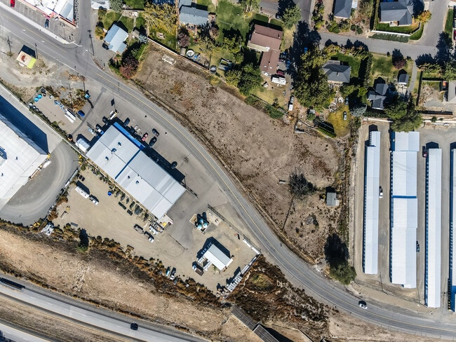

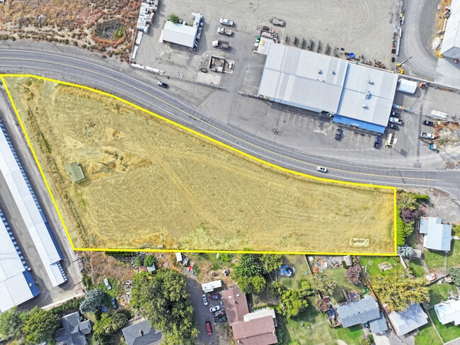
This Property Is For Sale
NEARBY LISTINGS FOR SALE OR LEASE
-
-
-
No Photo
-
View all Zillah listings for sale on LoopNet.com
Property Detail
1502 Kagley Way
211131-32428
PT GOV LOT 1 BEG 148.9 FT N & S 63^44 E 142.5 FT OF NW COR SD GOV LOT 1,TH S 63^44E 490.9 FT,TH S TO NLY STATE HY R/W (DIVISION RD),TH NWLY AL SD R/W > TO A PT BEARING S 28^15W FROM POB,TH N 28^15E TO POB
Vacantlandnec
Yakima
X
Washington
53077C1488D
1
2025
2.11 AC
2025
Outlying Yakima County
002201
Yakima
384 SF
Yakima, WA
DEMOGRAPHICS near 1502 Kagley Way
1 Mile
3 Mile
5 Mile
2024 Total Population
2,203
7,796
21,803
2029 Population
2,116
7,623
21,578
Pop Growth 2024-2029
(3.95%)
(2.22%)
(1.03%)
Average Age
37
35
34
2024 Total Households
744
2,353
6,152
HH Growth 2024-2029
(4.30%)
(2.63%)
(1.46%)
Median Household Inc
$67,129
$67,003
$63,477
Avg Household Size
3.00
3.30
3.50
2024 Avg HH Vehicles
2.00
2.00
2.00
Median Home Value
$266,421
$255,045
$235,897
Median Year Built
1976
1972
1971
Nearby Places
- Restaurants
- Banks
- Shops
- Fitness
- Groceries
PUBLIC TRANSPORTATION
AIRPORT
Yakima Air Trml/McAllister Field
DRIVE
WALK
Distance
Yakima Air Trml/McAllister Field
30 min
22.3 mi
Freight Ports
Port of Tacoma
DRIVE
WALK
Distance
Port of Tacoma
206 min
176.4 mi
Nearby Properties
Address
Land Use
TOTAL SIZE
Lot Size
Zoning
Address
Land Use
TOTAL SIZE
Lot Size
Zoning
324,769 SF
93.16 AC
M1
Address
Land Use
TOTAL SIZE
Lot Size
Zoning
121,029 SF
8.42 AC
M1
Address
Land Use
TOTAL SIZE
Lot Size
Zoning
54,446 SF
26.09 AC
PUB
Address
Land Use
TOTAL SIZE
Lot Size
Zoning
77,715 SF
16.56 AC
PC
Address
Land Use
TOTAL SIZE
Lot Size
Zoning
57,674 SF
31.43 AC
PC
Address
Land Use
TOTAL SIZE
Lot Size
Zoning
206,804 SF
10.74 AC
M1
Address
Land Use
TOTAL SIZE
Lot Size
Zoning
46,042 SF
5.97 AC
PC
Address
Land Use
TOTAL SIZE
Lot Size
Zoning
2,414 SF
195.87 AC
CT
Address
Land Use
TOTAL SIZE
Lot Size
Zoning
51,985 SF
1.61 AC
CT
Address
Land Use
TOTAL SIZE
Lot Size
Zoning
54,333 SF
4.43 AC
C1
Address
Land Use
TOTAL SIZE
Lot Size
Zoning
28,008 SF
2.42 AC
R3
Address
Land Use
TOTAL SIZE
Lot Size
Zoning
8,000 SF
2.71 AC
CT
Address
Land Use
TOTAL SIZE
Lot Size
Zoning
14,106 SF
5.16 AC
PC
Address
Land Use
TOTAL SIZE
Lot Size
Zoning
4,009 SF
1.11 AC
COM
Address
Land Use
TOTAL SIZE
Lot Size
Zoning
9,100 SF
0.84 AC
C1
Address
Land Use
TOTAL SIZE
Lot Size
Zoning
22,840 SF
1.53 AC
R3
Address
Land Use
TOTAL SIZE
Lot Size
Zoning
537.95 AC
AG
Address
Land Use
TOTAL SIZE
Lot Size
Zoning
6,176 SF
0.84 AC
CT
Address
Land Use
TOTAL SIZE
Lot Size
Zoning
38,488 SF
1.64 AC
PC
Address
Land Use
TOTAL SIZE
Lot Size
Zoning
12,079 SF
9.67 AC
AG
Address
Land Use
TOTAL SIZE
Lot Size
Zoning
32,925 SF
2.25 AC
PUB
Address
Land Use
TOTAL SIZE
Lot Size
Zoning
17,450 SF
2.79 AC
R10/5
Address
Land Use
TOTAL SIZE
Lot Size
Zoning
20,800 SF
2.07 AC
M1
Address
Land Use
TOTAL SIZE
Lot Size
Zoning
10,924 SF
7.07 AC
PC
Address
Land Use
TOTAL SIZE
Lot Size
Zoning
8,640 SF
0.97 AC
CT
Address
Land Use
TOTAL SIZE
Lot Size
Zoning
5,239 SF
1.14 AC
CT
Address
Land Use
TOTAL SIZE
Lot Size
Zoning
22,592 SF
1.98 AC
C1
Address
Land Use
TOTAL SIZE
Lot Size
Zoning
15,615 SF
3.91 AC
C1
Address
Land Use
TOTAL SIZE
Lot Size
Zoning
19,866 SF
20.20 AC
AG
Address
Land Use
TOTAL SIZE
Lot Size
Zoning
59,669 SF
6.75 AC
AG
The World's #1 Commercial Real Estate Marketplace
Connect with us
© 2025 CoStar Group
The information above has been obtained from sources believed reliable. While we do not doubt its accuracy we have not verified it and make no guarantee, warranty or representation about it. It is your responsibility to independently confirm its accuracy and completeness. Any projections, opinions, assumptions, or estimates used are for example only and do not represent the current or future performance of the property. The value of this transaction to you depends on tax and other factors which should be evaluated by your tax, financial, and legal advisors. You and your advisors should conduct a careful, independent investigation of the property to determine to your satisfaction the suitability of the property for your needs.