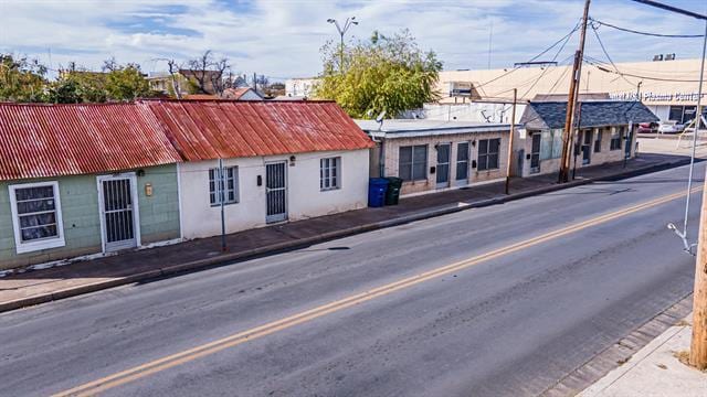
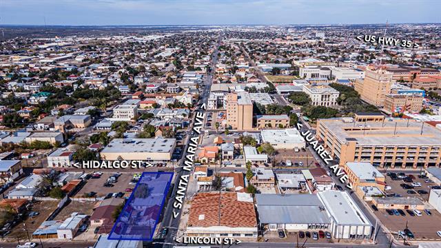
Property Record
1501 Hidalgo St, Laredo, TX 78040
Property Detail
1501 Hidalgo St
160839
LOT 6 BLK 151 WD
Multifamilydwelling
WEBB
RO
Texas
B and X Area of moderate flood hazard, usually the area between the limits of the 100-year and 500-year floods.
6
2024
0.14 AC
2025
Texas South Area
000800
Other Market Areas
2,134 SF
Laredo, TX
NEARBY LISTINGS FOR SALE OR LEASE
DEMOGRAPHICS near 1501 Hidalgo St
1 mile
3 mile
5 mile
2025 Total Population
11,248
75,298
167,823
2030 Population
11,604
76,695
171,266
Pop Growth 2025-2030
+ 3.17%
+ 1.86%
+ 2.05%
Average Age
38
36
35
2025 Total Households
3,743
24,088
50,254
HH Growth 2025-2030
+ 3.34%
+ 2.02%
+ 2.19%
Median Household Inc
$30,094
$41,103
$50,205
Avg Household Size
2.90
3.00
3.20
2025 Avg HH Vehicles
1.00
2.00
2.00
Median Home Value
$116,633
$157,677
$178,077
Median Year Built
1965
1975
1989
Nearby Places
Map Layers
Map Styles
 Street
 Aerial
Transit
 Traffic
 Biking
Places
Listings with unknown addresses are not visible on the map
- Restaurants
- Banks
- Shops
- Fitness
- Groceries
PUBLIC TRANSPORTATION
AIRPORT
Laredo International
Drive
Walk
Distance
Laredo International
14 min
7.0 mi
SALE & LEASE HISTORY
LISTING DATE
SALE/LEASE

Feb 04, 2025
For Sale
Nearby Properties
Address
Land Use
TOTAL SIZE
Lot Size
Zoning
Address
Land Use
TOTAL SIZE
Lot Size
Zoning
1,019,636 SF
202.89 AC
B3
Address
Land Use
TOTAL SIZE
Lot Size
Zoning
668,900 SF
38.32 AC
B4
Address
Land Use
TOTAL SIZE
Lot Size
Zoning
497,463 SF
1.77 AC
R1
Address
Land Use
TOTAL SIZE
Lot Size
Zoning
224,926 SF
21.49 AC
R3
Address
Land Use
TOTAL SIZE
Lot Size
Zoning
689,547 SF
2.70 AC
B3
Address
Land Use
TOTAL SIZE
Lot Size
Zoning
231,146 SF
1.77 AC
R1
Address
Land Use
TOTAL SIZE
Lot Size
Zoning
144,491 SF
3.54 AC
CBD
Address
Land Use
TOTAL SIZE
Lot Size
Zoning
96,991 SF
1.59 AC
CBD
Address
Land Use
TOTAL SIZE
Lot Size
Zoning
192,176 SF
34.94 AC
Address
Land Use
TOTAL SIZE
Lot Size
Zoning
127,364 SF
1.60 AC
CBD
Address
Land Use
TOTAL SIZE
Lot Size
Zoning
157,376 SF
25.86 AC
B3
Address
Land Use
TOTAL SIZE
Lot Size
Zoning
25,104 SF
1.42 AC
CBD
Address
Land Use
TOTAL SIZE
Lot Size
Zoning
101,734 SF
1.63 AC
B3
Address
Land Use
TOTAL SIZE
Lot Size
Zoning
66,567 SF
3.81 AC
M1
Address
Land Use
TOTAL SIZE
Lot Size
Zoning
113,687 SF
5.58 AC
R3
Address
Land Use
TOTAL SIZE
Lot Size
Zoning
93,414 SF
8.57 AC
R1
Address
Land Use
TOTAL SIZE
Lot Size
Zoning
102,815 SF
2.23 AC
Address
Land Use
TOTAL SIZE
Lot Size
Zoning
98,005 SF
0.67 AC
B3
Address
Land Use
TOTAL SIZE
Lot Size
Zoning
70,980 SF
1.44 AC
CBD
Address
Land Use
TOTAL SIZE
Lot Size
Zoning
97,580 SF
3.89 AC
B1
Address
Land Use
TOTAL SIZE
Lot Size
Zoning
94,056 SF
1.77 AC
Address
Land Use
TOTAL SIZE
Lot Size
Zoning
92,559 SF
5.70 AC
R1
Address
Land Use
TOTAL SIZE
Lot Size
Zoning
98,475 SF
1.59 AC
R3
Address
Land Use
TOTAL SIZE
Lot Size
Zoning
86,973 SF
8.57 AC
R1
Address
Land Use
TOTAL SIZE
Lot Size
Zoning
90,400 SF
1.77 AC
R3
Address
Land Use
TOTAL SIZE
Lot Size
Zoning
82,328 SF
5.12 AC
R3
Address
Land Use
TOTAL SIZE
Lot Size
Zoning
79,772 SF
1.77 AC
R3
Address
Land Use
TOTAL SIZE
Lot Size
Zoning
78,968 SF
3.51 AC
B1
Address
Land Use
TOTAL SIZE
Lot Size
Zoning
46,955 SF
6.80 AC
M1
Address
Land Use
TOTAL SIZE
Lot Size
Zoning
76,753 SF
0.89 AC
R3
The World's #1 Commercial Real Estate Marketplace
Connect with us
© 2026 CoStar Group
The information above has been obtained from sources believed reliable. While we do not doubt its accuracy we have not verified it and make no guarantee, warranty or representation about it. It is your responsibility to independently confirm its accuracy and completeness. Any projections, opinions, assumptions, or estimates used are for example only and do not represent the current or future performance of the property. The value of this transaction to you depends on tax and other factors which should be evaluated by your tax, financial, and legal advisors. You and your advisors should conduct a careful, independent investigation of the property to determine to your satisfaction the suitability of the property for your needs.