Property Record
1502 Main St, Seabrook, TX 77586
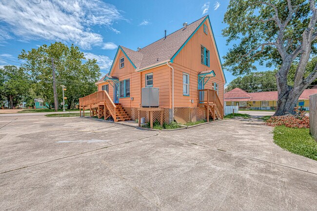

Property Detail
1502 Main St
0321340070011
TRS 6A & 7A BLK 7 SEABROOK
Storebuilding
Harris
VE and V1-30 Coastal areas with a 1% or greater chance of flooding and an additional hazard associated with storm waves. These areas have a 26% chance of flooding over the life of a 30-year mortgage.
Texas
2024
0.17 AC
2025
NASA/Clear Lake
341600
Houston
1,638 SF
Houston-Pasadena-The Woodlands, TX
NEARBY LISTINGS FOR SALE OR LEASE
DEMOGRAPHICS near 1502 Main St
1 mile
3 mile
5 mile
2025 Total Population
6,758
41,110
103,216
2030 Population
7,331
43,474
108,129
Pop Growth 2025-2030
+ 8.48%
+ 5.75%
+ 4.76%
Average Age
41
41
40
2025 Total Households
2,772
17,194
41,724
HH Growth 2025-2030
+ 8.69%
+ 5.84%
+ 4.93%
Median Household Inc
$110,096
$104,673
$101,003
Avg Household Size
2.40
2.40
2.40
2025 Avg HH Vehicles
2.00
2.00
2.00
Median Home Value
$354,266
$359,078
$352,819
Median Year Built
1987
1991
1991
Nearby Places
Map Layers
Map Styles
 Street
 Aerial
Layers
 Traffic
 Biking
Places
Listings with unknown addresses are not visible on the map
- Restaurants
- Banks
- Shops
- Fitness
- Groceries
PUBLIC TRANSPORTATION
AIRPORT
William P Hobby
Drive
Walk
Distance
William P Hobby
36 min
20.7 mi
George Bush Intcntl/Houston
Drive
Walk
Distance
George Bush Intcntl/Houston
55 min
43.4 mi
Freight Ports
Port of Galveston
Drive
Walk
Distance
Port of Galveston
32 min
25.9 mi
SALE & LEASE HISTORY
LISTING DATE
SALE/LEASE

Jun 26, 2024
For Lease
Feb 16, 2026
For Lease
Aug 18, 2017
For Lease
Nearby Properties
Address
Land Use
TOTAL SIZE
Lot Size
Zoning
Address
Land Use
TOTAL SIZE
Lot Size
Zoning
176.73 AC
Address
Land Use
TOTAL SIZE
Lot Size
Zoning
Address
Land Use
TOTAL SIZE
Lot Size
Zoning
2,312,750 SF
70.59 AC
Address
Land Use
TOTAL SIZE
Lot Size
Zoning
7.04 AC
Address
Land Use
TOTAL SIZE
Lot Size
Zoning
Address
Land Use
TOTAL SIZE
Lot Size
Zoning
400,835 SF
14.73 AC
Address
Land Use
TOTAL SIZE
Lot Size
Zoning
320,892 SF
15 AC
Address
Land Use
TOTAL SIZE
Lot Size
Zoning
468,294 SF
31.94 AC
Address
Land Use
TOTAL SIZE
Lot Size
Zoning
415,941 SF
14.35 AC
Address
Land Use
TOTAL SIZE
Lot Size
Zoning
260,988 SF
11.78 AC
Address
Land Use
TOTAL SIZE
Lot Size
Zoning
370,220 SF
28.57 AC
Address
Land Use
TOTAL SIZE
Lot Size
Zoning
126.63 AC
Address
Land Use
TOTAL SIZE
Lot Size
Zoning
177.18 AC
Address
Land Use
TOTAL SIZE
Lot Size
Zoning
176.70 AC
Address
Land Use
TOTAL SIZE
Lot Size
Zoning
176.70 AC
Address
Land Use
TOTAL SIZE
Lot Size
Zoning
281,944 SF
20.68 AC
Address
Land Use
TOTAL SIZE
Lot Size
Zoning
330,600 SF
14.88 AC
Address
Land Use
TOTAL SIZE
Lot Size
Zoning
196,951 SF
10.90 AC
Address
Land Use
TOTAL SIZE
Lot Size
Zoning
253,306 SF
12.33 AC
Address
Land Use
TOTAL SIZE
Lot Size
Zoning
188,850 SF
9.28 AC
Address
Land Use
TOTAL SIZE
Lot Size
Zoning
214,074 SF
12.70 AC
Address
Land Use
TOTAL SIZE
Lot Size
Zoning
207,624 SF
10.66 AC
Address
Land Use
TOTAL SIZE
Lot Size
Zoning
243,360 SF
12.22 AC
Address
Land Use
TOTAL SIZE
Lot Size
Zoning
227,210 SF
14.88 AC
Address
Land Use
TOTAL SIZE
Lot Size
Zoning
210,641 SF
7.59 AC
Address
Land Use
TOTAL SIZE
Lot Size
Zoning
256,771 SF
3.86 AC
Address
Land Use
TOTAL SIZE
Lot Size
Zoning
197,268 SF
3.43 AC
Address
Land Use
TOTAL SIZE
Lot Size
Zoning
115,444 SF
8.42 AC
Address
Land Use
TOTAL SIZE
Lot Size
Zoning
218,026 SF
13.13 AC
Address
Land Use
TOTAL SIZE
Lot Size
Zoning
180,139 SF
4.72 AC
The World's #1 Commercial Real Estate Marketplace
Connect with us
© 2026 CoStar Group
The information above has been obtained from sources believed reliable. While we do not doubt its accuracy we have not verified it and make no guarantee, warranty or representation about it. It is your responsibility to independently confirm its accuracy and completeness. Any projections, opinions, assumptions, or estimates used are for example only and do not represent the current or future performance of the property. The value of this transaction to you depends on tax and other factors which should be evaluated by your tax, financial, and legal advisors. You and your advisors should conduct a careful, independent investigation of the property to determine to your satisfaction the suitability of the property for your needs.