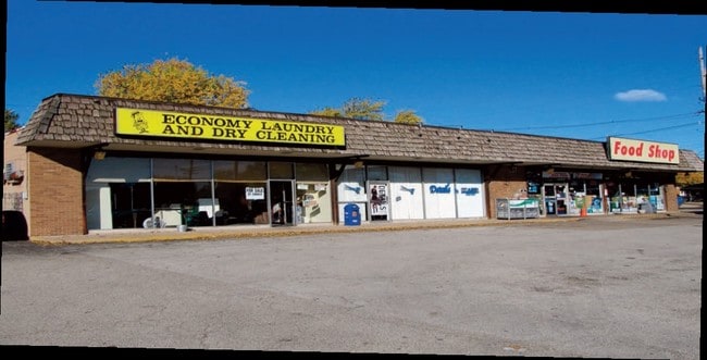
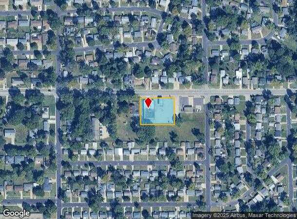
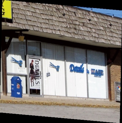
Property Record
1502 Sheridan Rd, Pekin, IL 61554
NEARBY LISTINGS FOR SALE OR LEASE
Property Detail
1502 Sheridan Rd
Peoria, IL
North Side Manor
04-04-35-215-025
NORTH SIDE MANOR #4 N163 OF W210 OF LOT 143
Storebuilding
Tazewell
X
Illinois
17179C0160E
143
2023
0.79 AC
2024
Outlying Tazewell County
020700
Peoria
6,600 SF
DEMOGRAPHICS near 1502 Sheridan Rd
1 Mile
3 Mile
5 Mile
2024 Total Population
11,683
34,223
49,137
2029 Population
11,505
33,737
48,369
Pop Growth 2024-2029
(1.52%)
(1.42%)
(1.56%)
Average Age
40
42
42
2024 Total Households
5,079
14,862
20,918
HH Growth 2024-2029
(1.56%)
(1.49%)
(1.64%)
Median Household Inc
$45,469
$50,030
$52,556
Avg Household Size
2.20
2.20
2.30
2024 Avg HH Vehicles
2.00
2.00
2.00
Median Home Value
$110,600
$121,170
$123,213
Median Year Built
1960
1961
1961
Nearby Places
Map Layers
Map Styles
 Street
 Aerial
- Restaurants
- Banks
- Shops
- Fitness
- Groceries
PUBLIC TRANSPORTATION
AIRPORT
General Downing - Peoria International
DRIVE
WALK
Distance
General Downing - Peoria International
18 min
11.0 mi
Freight Ports
Port Milwaukee
DRIVE
WALK
Distance
Port Milwaukee
279 min
237.7 mi
Nearby Properties
Address
Land Use
TOTAL SIZE
Lot Size
Zoning
Address
Land Use
TOTAL SIZE
Lot Size
Zoning
457,809 SF
97.96 AC
Address
Land Use
TOTAL SIZE
Lot Size
Zoning
24.82 AC
Address
Land Use
TOTAL SIZE
Lot Size
Zoning
214,634 SF
38.35 AC
Address
Land Use
TOTAL SIZE
Lot Size
Zoning
148,976 SF
1.90 AC
Address
Land Use
TOTAL SIZE
Lot Size
Zoning
159,468 SF
12.24 AC
Address
Land Use
TOTAL SIZE
Lot Size
Zoning
144,074 SF
3.89 AC
Address
Land Use
TOTAL SIZE
Lot Size
Zoning
138,686 SF
9.50 AC
Address
Land Use
TOTAL SIZE
Lot Size
Zoning
159,988 SF
11.41 AC
Address
Land Use
TOTAL SIZE
Lot Size
Zoning
75,625 SF
14.02 AC
Address
Land Use
TOTAL SIZE
Lot Size
Zoning
43,746 SF
5.10 AC
Address
Land Use
TOTAL SIZE
Lot Size
Zoning
99,465 SF
7.95 AC
Address
Land Use
TOTAL SIZE
Lot Size
Zoning
140,003 SF
9.98 AC
Address
Land Use
TOTAL SIZE
Lot Size
Zoning
44,556 SF
18.96 AC
Address
Land Use
TOTAL SIZE
Lot Size
Zoning
152,640 SF
19.34 AC
Address
Land Use
TOTAL SIZE
Lot Size
Zoning
330,215 SF
38.55 AC
Address
Land Use
TOTAL SIZE
Lot Size
Zoning
70,950 SF
3.88 AC
Address
Land Use
TOTAL SIZE
Lot Size
Zoning
90,938 SF
6.52 AC
Address
Land Use
TOTAL SIZE
Lot Size
Zoning
2.50 AC
Address
Land Use
TOTAL SIZE
Lot Size
Zoning
91,936 SF
10.64 AC
Address
Land Use
TOTAL SIZE
Lot Size
Zoning
59,066 SF
7.92 AC
Address
Land Use
TOTAL SIZE
Lot Size
Zoning
77,269 SF
5.90 AC
Address
Land Use
TOTAL SIZE
Lot Size
Zoning
22,800 SF
0.75 AC
Address
Land Use
TOTAL SIZE
Lot Size
Zoning
127,925 SF
8.48 AC
Address
Land Use
TOTAL SIZE
Lot Size
Zoning
64,472 SF
9.86 AC
Address
Land Use
TOTAL SIZE
Lot Size
Zoning
53,698 SF
4.79 AC
Address
Land Use
TOTAL SIZE
Lot Size
Zoning
35,376 SF
0.25 AC
Address
Land Use
TOTAL SIZE
Lot Size
Zoning
38,256 SF
4.52 AC
Address
Land Use
TOTAL SIZE
Lot Size
Zoning
13.49 AC
Address
Land Use
TOTAL SIZE
Lot Size
Zoning
27,605 SF
4.17 AC
Address
Land Use
TOTAL SIZE
Lot Size
Zoning
65,437 SF
5.43 AC
The World's #1 Commercial Real Estate Marketplace
Connect with us
© 2025 CoStar Group
The information above has been obtained from sources believed reliable. While we do not doubt its accuracy we have not verified it and make no guarantee, warranty or representation about it. It is your responsibility to independently confirm its accuracy and completeness. Any projections, opinions, assumptions, or estimates used are for example only and do not represent the current or future performance of the property. The value of this transaction to you depends on tax and other factors which should be evaluated by your tax, financial, and legal advisors. You and your advisors should conduct a careful, independent investigation of the property to determine to your satisfaction the suitability of the property for your needs.