Property Record
1502 Strand St, Galveston, TX 77550
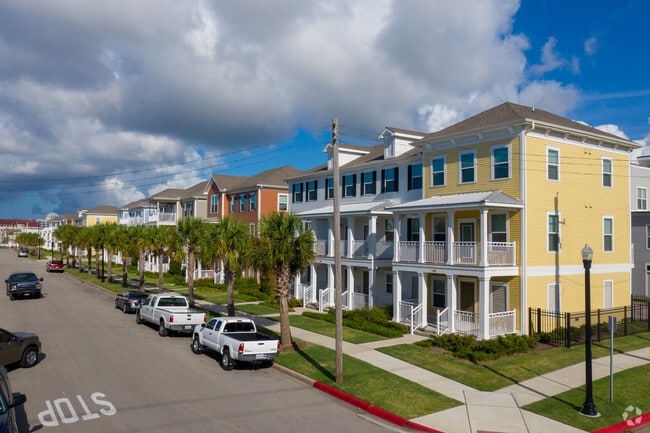

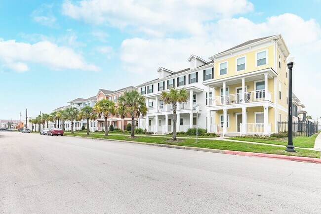
Property Detail
1502 Strand St
Houston-Pasadena-The Woodlands, TX
GALVESTON INITIATIVES I ADDN (2015) ABST 628, LOT 3, ACRES 1.7906
3511-0000-0003-000
GALVESTON
Apartment
Texas
AE The base floodplain where base flood elevations are provided. AE Zones are now used on new format FIRMs instead of A1-A30 Zones.
3
0
1.79 AC
2025
East End Historic District
724300
Houston
161,346 SF
NEARBY LISTINGS FOR SALE OR LEASE
DEMOGRAPHICS near 1502 Strand St
1 mile
3 mile
5 mile
2025 Total Population
11,355
38,862
54,811
2030 Population
12,159
41,415
58,059
Pop Growth 2025-2030
+ 7.08%
+ 6.57%
+ 5.93%
Average Age
43
42
42
2025 Total Households
5,711
16,818
23,681
HH Growth 2025-2030
+ 7.14%
+ 7.00%
+ 6.28%
Median Household Inc
$54,953
$52,093
$54,375
Avg Household Size
1.90
2.10
2.10
2025 Avg HH Vehicles
1.00
1.00
1.00
Median Home Value
$390,041
$330,471
$321,909
Median Year Built
1960
1962
1968
Nearby Places
Map Layers
Map Styles
 Street
 Aerial
Layers
 Traffic
 Biking
Places
Listings with unknown addresses are not visible on the map
- Restaurants
- Banks
- Shops
- Fitness
- Groceries
Nearby Properties
Address
Land Use
TOTAL SIZE
Lot Size
Zoning
Address
Land Use
TOTAL SIZE
Lot Size
Zoning
1,024,737 SF
6.16 AC
I
Address
Land Use
TOTAL SIZE
Lot Size
Zoning
566,062 SF
40.20 AC
Address
Land Use
TOTAL SIZE
Lot Size
Zoning
1,459,569 SF
11.51 AC
MF1
Address
Land Use
TOTAL SIZE
Lot Size
Zoning
457,632 SF
2.88 AC
I
Address
Land Use
TOTAL SIZE
Lot Size
Zoning
2,181,183 SF
236.11 AC
HI
Address
Land Use
TOTAL SIZE
Lot Size
Zoning
161,300 SF
Address
Land Use
TOTAL SIZE
Lot Size
Zoning
316,590 SF
2.97 AC
I
Address
Land Use
TOTAL SIZE
Lot Size
Zoning
376,136 SF
2.88 AC
I
Address
Land Use
TOTAL SIZE
Lot Size
Zoning
223,591 SF
Address
Land Use
TOTAL SIZE
Lot Size
Zoning
160,000 SF
1.79 AC
I
Address
Land Use
TOTAL SIZE
Lot Size
Zoning
226,301 SF
5.93 AC
I
Address
Land Use
TOTAL SIZE
Lot Size
Zoning
157,959 SF
1.79 AC
Address
Land Use
TOTAL SIZE
Lot Size
Zoning
346,554 SF
2.41 AC
I
Address
Land Use
TOTAL SIZE
Lot Size
Zoning
246,626 SF
4 AC
I
Address
Land Use
TOTAL SIZE
Lot Size
Zoning
346,355 SF
5.91 AC
Address
Land Use
TOTAL SIZE
Lot Size
Zoning
117,219 SF
2.27 AC
I
Address
Land Use
TOTAL SIZE
Lot Size
Zoning
178,711 SF
1.45 AC
I
Address
Land Use
TOTAL SIZE
Lot Size
Zoning
169,052 SF
4.18 AC
R
Address
Land Use
TOTAL SIZE
Lot Size
Zoning
182,000 SF
41.90 AC
Address
Land Use
TOTAL SIZE
Lot Size
Zoning
149,422 SF
1.79 AC
I
Address
Land Use
TOTAL SIZE
Lot Size
Zoning
122,655 SF
1.31 AC
I
Address
Land Use
TOTAL SIZE
Lot Size
Zoning
176,242 SF
2.03 AC
MF2
Address
Land Use
TOTAL SIZE
Lot Size
Zoning
79,660 SF
2.63 AC
I
Address
Land Use
TOTAL SIZE
Lot Size
Zoning
397,664 SF
1.79 AC
CB
Address
Land Use
TOTAL SIZE
Lot Size
Zoning
137,112 SF
318 AC
Address
Land Use
TOTAL SIZE
Lot Size
Zoning
60,550 SF
1.79 AC
Address
Land Use
TOTAL SIZE
Lot Size
Zoning
119,996 SF
2.86 AC
Address
Land Use
TOTAL SIZE
Lot Size
Zoning
125,400 SF
Address
Land Use
TOTAL SIZE
Lot Size
Zoning
80,726 SF
1.38 AC
I
The World's #1 Commercial Real Estate Marketplace
Connect with us
© 2026 CoStar Group
The information above has been obtained from sources believed reliable. While we do not doubt its accuracy we have not verified it and make no guarantee, warranty or representation about it. It is your responsibility to independently confirm its accuracy and completeness. Any projections, opinions, assumptions, or estimates used are for example only and do not represent the current or future performance of the property. The value of this transaction to you depends on tax and other factors which should be evaluated by your tax, financial, and legal advisors. You and your advisors should conduct a careful, independent investigation of the property to determine to your satisfaction the suitability of the property for your needs.