Property Record
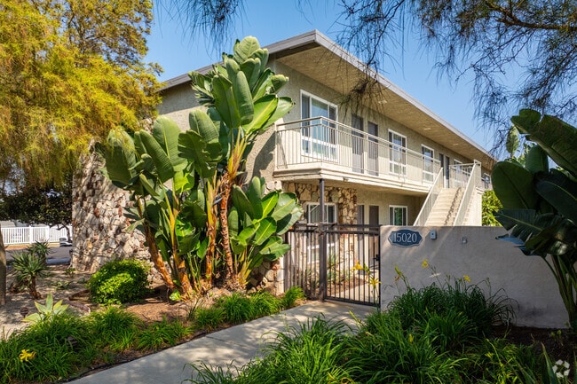
15020 Dublin Ave, Gardena, CA 90249


Property Detail
15020 Dublin Ave
4064-023-016
LOT COM AT SW COR OF LOT 31 TR # 13200 TH N 89 5810 W 271.2 FT TH N ON E LINE OF DUBLIN AVE AND E ON S LINE OF 150TH ST TO NW COR OF SD LOT TH S TO BEG PART OF SW 1/4 OF SE 1/4 OF NW 1/4 OF SEC 23 T 3S R 14W
Multifamilydwelling
Los Angeles
GAR1
California
B and X Area of moderate flood hazard, usually the area between the limits of the 100-year and 500-year floods.
31
2025
0.60 AC
2025
Gardena
603500
Los Angeles
21,048 SF
Los Angeles-Long Beach-Glendale, CA
NEARBY LISTINGS FOR SALE OR LEASE
DEMOGRAPHICS near 15020 Dublin Ave
1 mile
3 mile
5 mile
2025 Total Population
39,139
271,756
717,250
2030 Population
38,960
269,595
709,925
Pop Growth 2025-2030
(0.46%)
(0.80%)
(1.02%)
Average Age
40
40
39
2025 Total Households
13,589
91,004
234,151
HH Growth 2025-2030
(0.64%)
(0.98%)
(1.21%)
Median Household Inc
$75,593
$81,197
$87,670
Avg Household Size
2.80
2.90
2.90
2025 Avg HH Vehicles
2.00
2.00
2.00
Median Home Value
$736,470
$769,785
$821,828
Median Year Built
1962
1961
1961
Nearby Places
Map Layers
Map Styles
 Street
 Aerial
Layers
 Traffic
 Biking
Places
Listings with unknown addresses are not visible on the map
- Restaurants
- Banks
- Shops
- Fitness
- Groceries
PUBLIC TRANSPORTATION
AIRPORT
Los Angeles International
Drive
Walk
Distance
Los Angeles International
14 min
8.8 mi
Long Beach (Daugherty Field)
Drive
Walk
Distance
Long Beach (Daugherty Field)
20 min
13.7 mi
Bob Hope
Drive
Walk
Distance
Bob Hope
41 min
30.8 mi
Freight Ports
Port of Los Angeles
Drive
Walk
Distance
Port of Los Angeles
27 min
16.6 mi
Nearby Properties
Address
Land Use
TOTAL SIZE
Lot Size
Zoning
Address
Land Use
TOTAL SIZE
Lot Size
Zoning
10,152 SF
140.14 AC
TOMI-HVY
Address
Land Use
TOTAL SIZE
Lot Size
Zoning
319,182 SF
13.30 AC
LCM11/2-B1
Address
Land Use
TOTAL SIZE
Lot Size
Zoning
803,362 SF
41.24 AC
RBI-1A
Address
Land Use
TOTAL SIZE
Lot Size
Zoning
848,217 SF
36.09 AC
RBI-1A
Address
Land Use
TOTAL SIZE
Lot Size
Zoning
604,106 SF
42.72 AC
TOMI-HVY
Address
Land Use
TOTAL SIZE
Lot Size
Zoning
227,596 SF
14.38 AC
HAM1YY
Address
Land Use
TOTAL SIZE
Lot Size
Zoning
1,504,661 SF
RBCR
Address
Land Use
TOTAL SIZE
Lot Size
Zoning
3,585,714 SF
67.35 AC
LAM3
Address
Land Use
TOTAL SIZE
Lot Size
Zoning
216,354 SF
3.52 AC
HAC3
Address
Land Use
TOTAL SIZE
Lot Size
Zoning
214,782 SF
3.66 AC
GAR3
Address
Land Use
TOTAL SIZE
Lot Size
Zoning
239,992 SF
4.72 AC
RBI-1B
Address
Land Use
TOTAL SIZE
Lot Size
Zoning
986,604 SF
42.66 AC
HAM2YY
Address
Land Use
TOTAL SIZE
Lot Size
Zoning
59,422 SF
2.89 AC
HAM2YY
Address
Land Use
TOTAL SIZE
Lot Size
Zoning
316,111 SF
12.61 AC
RBI-1
Address
Land Use
TOTAL SIZE
Lot Size
Zoning
544,967 SF
10.74 AC
HAM2YY
Address
Land Use
TOTAL SIZE
Lot Size
Zoning
24,060 SF
LAM2
Address
Land Use
TOTAL SIZE
Lot Size
Zoning
155,099 SF
7.74 AC
TOMI-HVY
Address
Land Use
TOTAL SIZE
Lot Size
Zoning
383,794 SF
10.74 AC
TOMI-LT
Address
Land Use
TOTAL SIZE
Lot Size
Zoning
269,988 SF
5.52 AC
TOMI-BP
Address
Land Use
TOTAL SIZE
Lot Size
Zoning
301,506 SF
CAML*
Address
Land Use
TOTAL SIZE
Lot Size
Zoning
169,426 SF
3.50 AC
LCM11/2-B1
Address
Land Use
TOTAL SIZE
Lot Size
Zoning
111,855 SF
6.63 AC
RBI-1
Address
Land Use
TOTAL SIZE
Lot Size
Zoning
147,319 SF
6.88 AC
TOMI-BP
Address
Land Use
TOTAL SIZE
Lot Size
Zoning
121,090 SF
4.18 AC
LCM2*
Address
Land Use
TOTAL SIZE
Lot Size
Zoning
112,866 SF
3.95 AC
RBCR
Address
Land Use
TOTAL SIZE
Lot Size
Zoning
212,771 SF
7.81 AC
LAM2
Address
Land Use
TOTAL SIZE
Lot Size
Zoning
132,173 SF
11.53 AC
LCM2-B1*
Address
Land Use
TOTAL SIZE
Lot Size
Zoning
1,030,435 SF
23.22 AC
RBI-1A
Address
Land Use
TOTAL SIZE
Lot Size
Zoning
153,291 SF
14.89 AC
LAC2
Address
Land Use
TOTAL SIZE
Lot Size
Zoning
147,280 SF
6.58 AC
CAML*
The World's #1 Commercial Real Estate Marketplace
Connect with us
© 2026 CoStar Group
The information above has been obtained from sources believed reliable. While we do not doubt its accuracy we have not verified it and make no guarantee, warranty or representation about it. It is your responsibility to independently confirm its accuracy and completeness. Any projections, opinions, assumptions, or estimates used are for example only and do not represent the current or future performance of the property. The value of this transaction to you depends on tax and other factors which should be evaluated by your tax, financial, and legal advisors. You and your advisors should conduct a careful, independent investigation of the property to determine to your satisfaction the suitability of the property for your needs.