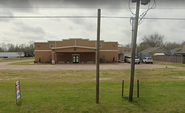
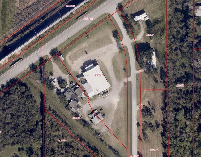
Property Record
1503 A Hwy N, Rosenberg, TX 77471

Save to a Folder
{{folder.Name}}
{{folder.ListingIds.length}} Properties
{{folder.ListingIds.length}} Property
Create a New Folder
Property Detail
1503 A Hwy N
3018-00-000-0011-901
FIFTY-NINE SO INDUSTRIAL PARK, ACRES 2.313, (PT) RESERVE A
Commercialnec
FORT BEND
AE The base floodplain where base flood elevations are provided. AE Zones are now used on new format FIRMs instead of A1-A30 Zones.
Texas
2024
2.31 AC
2025
Southwest Outlier
675300
Houston
11,232 SF
Houston-Pasadena-The Woodlands, TX
NEARBY LISTINGS FOR SALE OR LEASE
DEMOGRAPHICS near 1503 A Hwy N
1 mile
3 mile
5 mile
2025 Total Population
2,563
25,307
59,821
2030 Population
2,889
28,784
68,212
Pop Growth 2025-2030
+ 12.72%
+ 13.74%
+ 14.03%
Average Age
36
37
37
2025 Total Households
746
8,374
19,852
HH Growth 2025-2030
+ 13.27%
+ 14.12%
+ 14.42%
Median Household Inc
$53,397
$67,332
$70,569
Avg Household Size
3.40
3.00
3.00
2025 Avg HH Vehicles
2.00
2.00
2.00
Median Home Value
$79,738
$224,291
$250,454
Median Year Built
1995
1991
1995
Nearby Places
Map Layers
Map Styles
 Street
 Aerial
Layers
 Traffic
 Biking
Places
Listings with unknown addresses are not visible on the map
- Restaurants
- Banks
- Shops
- Fitness
- Groceries
PUBLIC TRANSPORTATION
AIRPORT
William P Hobby
Drive
Walk
Distance
William P Hobby
58 min
42.8 mi
Freight Ports
Port of Houston
Drive
Walk
Distance
Port of Houston
61 min
45.0 mi
Nearby Properties
Address
Land Use
TOTAL SIZE
Lot Size
Zoning
Address
Land Use
TOTAL SIZE
Lot Size
Zoning
146.35 AC
ST
Address
Land Use
TOTAL SIZE
Lot Size
Zoning
44.35 AC
YOSN
Address
Land Use
TOTAL SIZE
Lot Size
Zoning
672,112 SF
81.77 AC
YHN
Address
Land Use
TOTAL SIZE
Lot Size
Zoning
98,691 SF
29.37 AC
Address
Land Use
TOTAL SIZE
Lot Size
Zoning
16.23 AC
Address
Land Use
TOTAL SIZE
Lot Size
Zoning
672 SF
230.34 AC
YT
Address
Land Use
TOTAL SIZE
Lot Size
Zoning
54,406 SF
13.13 AC
Address
Land Use
TOTAL SIZE
Lot Size
Zoning
54.25 AC
L
Address
Land Use
TOTAL SIZE
Lot Size
Zoning
37.08 AC
Address
Land Use
TOTAL SIZE
Lot Size
Zoning
1,216 SF
24.38 AC
YZS
Address
Land Use
TOTAL SIZE
Lot Size
Zoning
66,896 SF
18.60 AC
ZNY
Address
Land Use
TOTAL SIZE
Lot Size
Zoning
25.69 AC
Address
Land Use
TOTAL SIZE
Lot Size
Zoning
4,524 SF
13.68 AC
Address
Land Use
TOTAL SIZE
Lot Size
Zoning
37,951 SF
5.39 AC
L
Address
Land Use
TOTAL SIZE
Lot Size
Zoning
145,000 SF
17.36 AC
YSNM
Address
Land Use
TOTAL SIZE
Lot Size
Zoning
30.57 AC
Address
Land Use
TOTAL SIZE
Lot Size
Zoning
8.01 AC
Address
Land Use
TOTAL SIZE
Lot Size
Zoning
4.20 AC
YS
Address
Land Use
TOTAL SIZE
Lot Size
Zoning
21,218 SF
1.86 AC
Address
Land Use
TOTAL SIZE
Lot Size
Zoning
133,826 SF
11.60 AC
Address
Land Use
TOTAL SIZE
Lot Size
Zoning
45,695 SF
3.38 AC
XY
Address
Land Use
TOTAL SIZE
Lot Size
Zoning
7.89 AC
SZ
Address
Land Use
TOTAL SIZE
Lot Size
Zoning
11,800 SF
9.26 AC
S
Address
Land Use
TOTAL SIZE
Lot Size
Zoning
40.49 AC
OY
Address
Land Use
TOTAL SIZE
Lot Size
Zoning
175,001 SF
14.37 AC
SY
Address
Land Use
TOTAL SIZE
Lot Size
Zoning
220,453 SF
142.24 AC
SQ
Address
Land Use
TOTAL SIZE
Lot Size
Zoning
82,127 SF
6.18 AC
L
Address
Land Use
TOTAL SIZE
Lot Size
Zoning
62,521 SF
3.05 AC
XY
Address
Land Use
TOTAL SIZE
Lot Size
Zoning
85,000 SF
19.49 AC
SN
Address
Land Use
TOTAL SIZE
Lot Size
Zoning
1,064 SF
68.45 AC
OQY
The World's #1 Commercial Real Estate Marketplace
Connect with us
© 2026 CoStar Group
The information above has been obtained from sources believed reliable. While we do not doubt its accuracy we have not verified it and make no guarantee, warranty or representation about it. It is your responsibility to independently confirm its accuracy and completeness. Any projections, opinions, assumptions, or estimates used are for example only and do not represent the current or future performance of the property. The value of this transaction to you depends on tax and other factors which should be evaluated by your tax, financial, and legal advisors. You and your advisors should conduct a careful, independent investigation of the property to determine to your satisfaction the suitability of the property for your needs.