Property Record
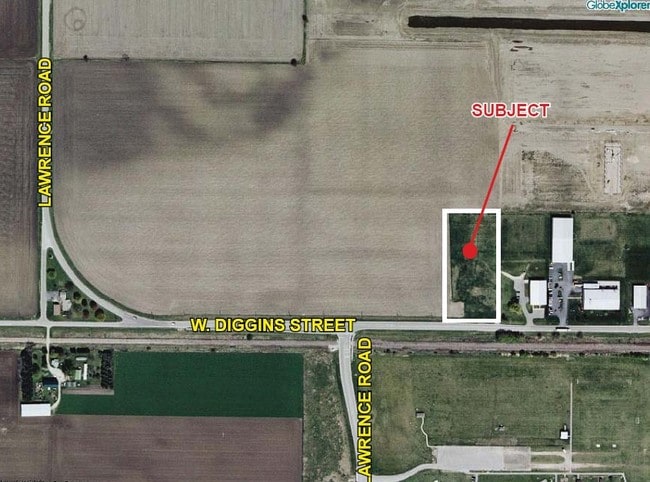
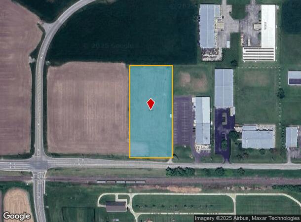
1503 W Diggins St, Harvard, IL 60033
NEARBY LISTINGS FOR SALE OR LEASE
Property Detail
1503 W Diggins St
Chicago-Naperville-Elgin, IL-IN
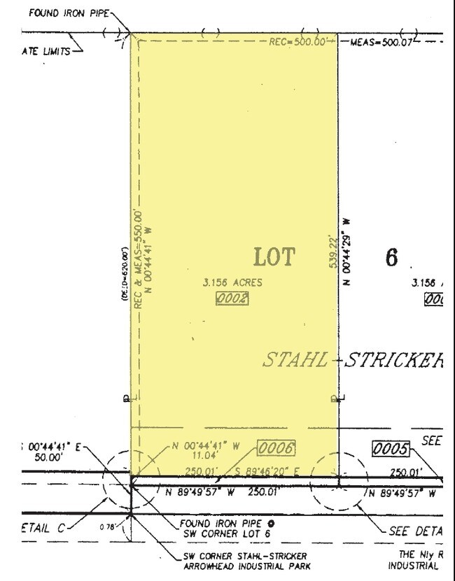
Stahl-Stricker Industrial Park
01-34-200-030
DOC 2022R0041014 W1/2 LT 6 /EX DOC 1999R0017152/ STAHL-STRICKER INDUSTRIAL PARK MEMO: CASCIARO, JOHN M/HEIDE B JNT TR
Industrialgeneral
McHenry
X
Illinois
17007C0075C
6
2024
3 AC
2024
Far Northwest
870301
Chicago
DEMOGRAPHICS near 1503 W Diggins St
1 Mile
3 Mile
5 Mile
2024 Total Population
3,542
10,767
12,350
2029 Population
3,552
10,784
12,348
Pop Growth 2024-2029
+ 0.28%
+ 0.16%
(0.02%)
Average Age
36
37
38
2024 Total Households
1,237
3,672
4,274
HH Growth 2024-2029
+ 0.24%
+ 0.16%
(0.02%)
Median Household Inc
$53,454
$64,268
$66,217
Avg Household Size
2.80
2.90
2.80
2024 Avg HH Vehicles
2.00
2.00
2.00
Median Home Value
$143,908
$161,639
$169,291
Median Year Built
1977
1980
1979
Nearby Places
Map Layers
Map Styles
 Street
 Aerial
- Restaurants
- Banks
- Shops
- Fitness
- Groceries
PUBLIC TRANSPORTATION
COMMUTER RAIL
Harvard Station (Union Pacific Northwest Line - Northeast Illinois Regional Commuter Railroad (Metra))
DRIVE
WALK
Distance
Harvard Station (Union Pacific Northwest Line - Northeast Illinois Regional Commuter Railroad (Metra))
4 min
20 min
1.0 mi
AIRPORT
Chicago/Rockford International
DRIVE
WALK
Distance
Chicago/Rockford International
58 min
40.1 mi
Freight Ports
Port Milwaukee
DRIVE
WALK
Distance
Port Milwaukee
85 min
64.7 mi
Nearby Properties
Address
Land Use
TOTAL SIZE
Lot Size
Zoning
Address
Land Use
TOTAL SIZE
Lot Size
Zoning
23.89 AC
Address
Land Use
TOTAL SIZE
Lot Size
Zoning
290.30 AC
Address
Land Use
TOTAL SIZE
Lot Size
Zoning
150,352 SF
16.65 AC
Address
Land Use
TOTAL SIZE
Lot Size
Zoning
457,340 SF
19.04 AC
Address
Land Use
TOTAL SIZE
Lot Size
Zoning
8.38 AC
Address
Land Use
TOTAL SIZE
Lot Size
Zoning
4.34 AC
Address
Land Use
TOTAL SIZE
Lot Size
Zoning
6.51 AC
Address
Land Use
TOTAL SIZE
Lot Size
Zoning
346,000 SF
11.50 AC
Address
Land Use
TOTAL SIZE
Lot Size
Zoning
17.16 AC
Address
Land Use
TOTAL SIZE
Lot Size
Zoning
5.89 AC
Address
Land Use
TOTAL SIZE
Lot Size
Zoning
209,100 SF
8.04 AC
Address
Land Use
TOTAL SIZE
Lot Size
Zoning
14.99 AC
Address
Land Use
TOTAL SIZE
Lot Size
Zoning
292,500 SF
17.66 AC
Address
Land Use
TOTAL SIZE
Lot Size
Zoning
Address
Land Use
TOTAL SIZE
Lot Size
Zoning
3.44 AC
Address
Land Use
TOTAL SIZE
Lot Size
Zoning
25,475 SF
2.69 AC
Address
Land Use
TOTAL SIZE
Lot Size
Zoning
3.16 AC
Address
Land Use
TOTAL SIZE
Lot Size
Zoning
3.74 AC
Address
Land Use
TOTAL SIZE
Lot Size
Zoning
7,232 SF
2.15 AC
Address
Land Use
TOTAL SIZE
Lot Size
Zoning
Address
Land Use
TOTAL SIZE
Lot Size
Zoning
45,771 SF
5.90 AC
Address
Land Use
TOTAL SIZE
Lot Size
Zoning
52,107 SF
5.03 AC
Address
Land Use
TOTAL SIZE
Lot Size
Zoning
2.23 AC
Address
Land Use
TOTAL SIZE
Lot Size
Zoning
1.31 AC
Address
Land Use
TOTAL SIZE
Lot Size
Zoning
13,619 SF
1.66 AC
Address
Land Use
TOTAL SIZE
Lot Size
Zoning
15,750 SF
1.60 AC
Address
Land Use
TOTAL SIZE
Lot Size
Zoning
29,076 SF
1.75 AC
Address
Land Use
TOTAL SIZE
Lot Size
Zoning
0.98 AC
Address
Land Use
TOTAL SIZE
Lot Size
Zoning
0.49 AC
Address
Land Use
TOTAL SIZE
Lot Size
Zoning
20,434 SF
0.65 AC
The World's #1 Commercial Real Estate Marketplace
Connect with us
© 2026 CoStar Group
The information above has been obtained from sources believed reliable. While we do not doubt its accuracy we have not verified it and make no guarantee, warranty or representation about it. It is your responsibility to independently confirm its accuracy and completeness. Any projections, opinions, assumptions, or estimates used are for example only and do not represent the current or future performance of the property. The value of this transaction to you depends on tax and other factors which should be evaluated by your tax, financial, and legal advisors. You and your advisors should conduct a careful, independent investigation of the property to determine to your satisfaction the suitability of the property for your needs.