Property Record
1503 E 10Th St, Rolla, MO 65401


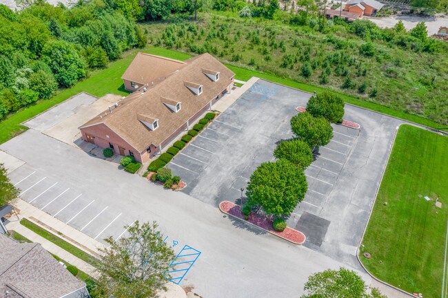

Property Detail
1503 E 10Th St
71-10-3.2-06-031-001-036.002
FRACTIONAL PART TRACT 1 HERITAGE HEIGHTS ADDITION SEC 6 TWP 37 N RNG 7 W
Officebuilding
Phelps
AE The base floodplain where base flood elevations are provided. AE Zones are now used on new format FIRMs instead of A1-A30 Zones.
Missouri
2024
1.50 AC
2025
Missouri South Central Area
890301
Other Market Areas
6,160 SF
Rolla, MO
NEARBY LISTINGS FOR SALE OR LEASE
-
-
View all Rolla listings for sale on LoopNet.com
DEMOGRAPHICS near 1503 E 10Th St
1 mile
3 mile
5 mile
2025 Total Population
6,437
23,979
28,299
2030 Population
6,529
24,411
28,824
Pop Growth 2025-2030
+ 1.43%
+ 1.80%
+ 1.86%
Average Age
38
37
37
2025 Total Households
2,902
9,676
11,343
HH Growth 2025-2030
+ 1.45%
+ 1.97%
+ 2.00%
Median Household Inc
$46,146
$48,005
$50,486
Avg Household Size
2.10
2.20
2.20
2025 Avg HH Vehicles
2.00
2.00
2.00
Median Home Value
$168,929
$205,022
$217,793
Median Year Built
1979
1984
1984
Nearby Places
Map Layers
Map Styles
 Street
 Aerial
Transit
 Traffic
 Biking
Places
Listings with unknown addresses are not visible on the map
- Restaurants
- Banks
- Shops
- Fitness
- Groceries
SALE & LEASE HISTORY
LISTING DATE
SALE/LEASE

Mar 29, 2021
For Sale
Nearby Properties
Address
Land Use
TOTAL SIZE
Lot Size
Zoning
Address
Land Use
TOTAL SIZE
Lot Size
Zoning
672 SF
9 AC
Address
Land Use
TOTAL SIZE
Lot Size
Zoning
55,554 SF
20.40 AC
Address
Land Use
TOTAL SIZE
Lot Size
Zoning
11,964 SF
8.70 AC
Address
Land Use
TOTAL SIZE
Lot Size
Zoning
18.20 AC
Address
Land Use
TOTAL SIZE
Lot Size
Zoning
173,404 SF
20.30 AC
Address
Land Use
TOTAL SIZE
Lot Size
Zoning
121,000 SF
20.40 AC
Address
Land Use
TOTAL SIZE
Lot Size
Zoning
85,600 SF
85.80 AC
Address
Land Use
TOTAL SIZE
Lot Size
Zoning
129,863 SF
11.80 AC
Address
Land Use
TOTAL SIZE
Lot Size
Zoning
96,905 SF
11.70 AC
Address
Land Use
TOTAL SIZE
Lot Size
Zoning
143,166 SF
23.80 AC
Address
Land Use
TOTAL SIZE
Lot Size
Zoning
61,591 SF
22.30 AC
Address
Land Use
TOTAL SIZE
Lot Size
Zoning
55,481 SF
8.20 AC
Address
Land Use
TOTAL SIZE
Lot Size
Zoning
6,000 SF
32.40 AC
Address
Land Use
TOTAL SIZE
Lot Size
Zoning
15,900 SF
4.20 AC
Address
Land Use
TOTAL SIZE
Lot Size
Zoning
4,792 SF
20.90 AC
Address
Land Use
TOTAL SIZE
Lot Size
Zoning
62,623 SF
7.70 AC
Address
Land Use
TOTAL SIZE
Lot Size
Zoning
63,810 SF
20.60 AC
Address
Land Use
TOTAL SIZE
Lot Size
Zoning
4,118 SF
11.50 AC
Address
Land Use
TOTAL SIZE
Lot Size
Zoning
45,354 SF
3.40 AC
Address
Land Use
TOTAL SIZE
Lot Size
Zoning
37,035 SF
1.80 AC
Address
Land Use
TOTAL SIZE
Lot Size
Zoning
49,500 SF
5.90 AC
Address
Land Use
TOTAL SIZE
Lot Size
Zoning
48,176 SF
5.10 AC
Address
Land Use
TOTAL SIZE
Lot Size
Zoning
105,208 SF
8.70 AC
Address
Land Use
TOTAL SIZE
Lot Size
Zoning
38,550 SF
5.20 AC
Address
Land Use
TOTAL SIZE
Lot Size
Zoning
24,144 SF
2.70 AC
Address
Land Use
TOTAL SIZE
Lot Size
Zoning
4,800 SF
2.10 AC
Address
Land Use
TOTAL SIZE
Lot Size
Zoning
28,604 SF
6.80 AC
Address
Land Use
TOTAL SIZE
Lot Size
Zoning
3,670 SF
5.20 AC
Address
Land Use
TOTAL SIZE
Lot Size
Zoning
38,726 SF
8 AC
Address
Land Use
TOTAL SIZE
Lot Size
Zoning
168,500 SF
6.90 AC
The World's #1 Commercial Real Estate Marketplace
Connect with us
© 2026 CoStar Group
The information above has been obtained from sources believed reliable. While we do not doubt its accuracy we have not verified it and make no guarantee, warranty or representation about it. It is your responsibility to independently confirm its accuracy and completeness. Any projections, opinions, assumptions, or estimates used are for example only and do not represent the current or future performance of the property. The value of this transaction to you depends on tax and other factors which should be evaluated by your tax, financial, and legal advisors. You and your advisors should conduct a careful, independent investigation of the property to determine to your satisfaction the suitability of the property for your needs.