Property Record
1503 Hardeman Ave, Macon, GA 31201
Save to a Folder
{{folder.Name}}
{{folder.ListingIds.length}} Properties
{{folder.ListingIds.length}} Property
Create a New Folder
This Property Is For Sale
Property Detail
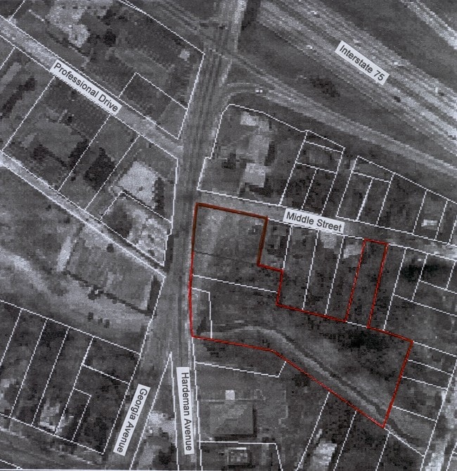
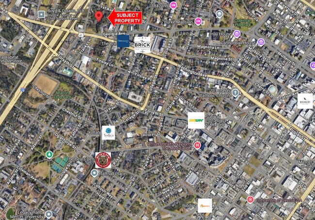
1503 Hardeman Ave
Q073-0130
N W C
Commercialacreage
BIBB
C-2
Georgia
A Areas with a 1% annual chance of flooding and a 26% chance of flooding over the life of a 30-year mortgage.
0.11 AC
2025
Suburban Macon
2025
Atlanta
013701
Macon-Bibb County, GA
NEARBY LISTINGS FOR SALE OR LEASE
DEMOGRAPHICS near 1503 Hardeman Ave
1 mile
3 mile
5 mile
2025 Total Population
10,396
50,738
92,006
2030 Population
10,653
51,769
93,178
Pop Growth 2025-2030
+ 2.47%
+ 2.03%
+ 1.27%
Average Age
38
38
38
2025 Total Households
4,879
21,263
37,431
HH Growth 2025-2030
+ 2.56%
+ 2.14%
+ 1.34%
Median Household Inc
$28,875
$32,033
$38,246
Avg Household Size
1.90
2.20
2.30
2025 Avg HH Vehicles
1.00
1.00
1.00
Median Home Value
$225,000
$160,481
$155,336
Median Year Built
1955
1959
1965
Nearby Places
Map Layers
Map Styles
 Street
 Aerial
Layers
 Traffic
 Biking
Places
Listings with unknown addresses are not visible on the map
- Restaurants
- Banks
- Shops
- Fitness
- Groceries
Nearby Properties
Address
Land Use
TOTAL SIZE
Lot Size
Zoning
Address
Land Use
TOTAL SIZE
Lot Size
Zoning
55,368 SF
9.53 AC
CBD-2
Address
Land Use
TOTAL SIZE
Lot Size
Zoning
213,690 SF
2.25 AC
CBD-1
Address
Land Use
TOTAL SIZE
Lot Size
Zoning
154,196 SF
44.86 AC
R-1A
Address
Land Use
TOTAL SIZE
Lot Size
Zoning
63,394 SF
5.30 AC
M-1/R-3
Address
Land Use
TOTAL SIZE
Lot Size
Zoning
100,599 SF
0.43 AC
CBD-1
Address
Land Use
TOTAL SIZE
Lot Size
Zoning
158,480 SF
0.90 AC
CBD-2
Address
Land Use
TOTAL SIZE
Lot Size
Zoning
241,380 SF
12.38 AC
C-2
Address
Land Use
TOTAL SIZE
Lot Size
Zoning
181,396 SF
44.77 AC
R-1A
Address
Land Use
TOTAL SIZE
Lot Size
Zoning
127,536 SF
3.56 AC
PDE
Address
Land Use
TOTAL SIZE
Lot Size
Zoning
155,678 SF
3.85 AC
CBD-2
Address
Land Use
TOTAL SIZE
Lot Size
Zoning
199,096 SF
22.03 AC
R-2
Address
Land Use
TOTAL SIZE
Lot Size
Zoning
171,386 SF
36.41 AC
CBD-2
Address
Land Use
TOTAL SIZE
Lot Size
Zoning
92,712 SF
2.93 AC
CBD-2
Address
Land Use
TOTAL SIZE
Lot Size
Zoning
145,967 SF
2.53 AC
C-4
Address
Land Use
TOTAL SIZE
Lot Size
Zoning
98,928 SF
12.32 AC
R-3
Address
Land Use
TOTAL SIZE
Lot Size
Zoning
114,156 SF
0.86 AC
CBD-1
Address
Land Use
TOTAL SIZE
Lot Size
Zoning
85,556 SF
10.50 AC
R-1A
Address
Land Use
TOTAL SIZE
Lot Size
Zoning
110,153 SF
22 AC
R-2
Address
Land Use
TOTAL SIZE
Lot Size
Zoning
246,724 SF
0.75 AC
CBD-1
Address
Land Use
TOTAL SIZE
Lot Size
Zoning
141,816 SF
16.44 AC
C-2
Address
Land Use
TOTAL SIZE
Lot Size
Zoning
46,288 SF
1.80 AC
PDE
Address
Land Use
TOTAL SIZE
Lot Size
Zoning
33,248 SF
10.18 AC
R-3
Address
Land Use
TOTAL SIZE
Lot Size
Zoning
69,260 SF
0.41 AC
CBD-1
Address
Land Use
TOTAL SIZE
Lot Size
Zoning
60,432 SF
0.98 AC
CBD-1
Address
Land Use
TOTAL SIZE
Lot Size
Zoning
94,540 SF
6.15 AC
R-2
Address
Land Use
TOTAL SIZE
Lot Size
Zoning
119,564 SF
3.89 AC
R-3
Address
Land Use
TOTAL SIZE
Lot Size
Zoning
96,512 SF
11.30 AC
PDE
Address
Land Use
TOTAL SIZE
Lot Size
Zoning
58,730 SF
3.42 AC
R-3
Address
Land Use
TOTAL SIZE
Lot Size
Zoning
46,174 SF
9.67 AC
R-2
Address
Land Use
TOTAL SIZE
Lot Size
Zoning
140 SF
29.43 AC
R-1
The World's #1 Commercial Real Estate Marketplace
Connect with us
© 2026 CoStar Group
The information above has been obtained from sources believed reliable. While we do not doubt its accuracy we have not verified it and make no guarantee, warranty or representation about it. It is your responsibility to independently confirm its accuracy and completeness. Any projections, opinions, assumptions, or estimates used are for example only and do not represent the current or future performance of the property. The value of this transaction to you depends on tax and other factors which should be evaluated by your tax, financial, and legal advisors. You and your advisors should conduct a careful, independent investigation of the property to determine to your satisfaction the suitability of the property for your needs.