Property Record
1503 N Green St, Morganton, NC 28655
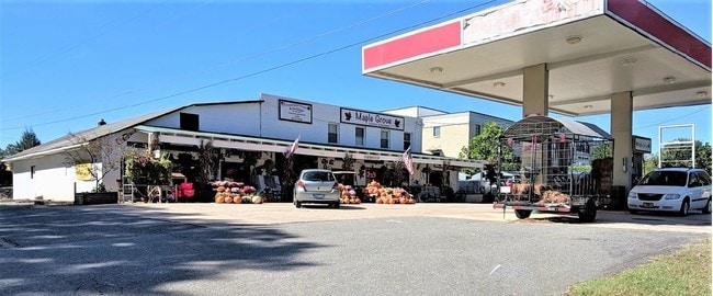

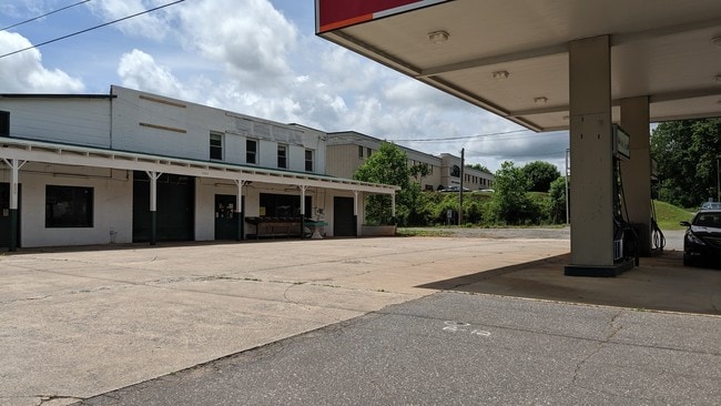
Property Detail
1503 N Green St
22592
1503 N GREEN ST MORGANTON, NC 28655
Realpropertynec
Burke
HIGH INTEN
North Carolina
B and X Area of moderate flood hazard, usually the area between the limits of the 100-year and 500-year floods.
0.54 AC
2025
Burke County
2025
Charlotte
020202
Hickory-Lenoir-Morganton, NC
6,916 SF
NEARBY LISTINGS FOR SALE OR LEASE
DEMOGRAPHICS near 1503 N Green St
1 mile
3 mile
5 mile
2025 Total Population
1,596
13,860
30,154
2030 Population
1,596
13,923
30,456
Pop Growth 2025-2030
0.00%
+ 0.45%
+ 1.00%
Average Age
47
43
43
2025 Total Households
662
5,610
12,200
HH Growth 2025-2030
0.00%
+ 0.55%
+ 1.12%
Median Household Inc
$63,785
$51,690
$53,178
Avg Household Size
2.40
2.40
2.40
2025 Avg HH Vehicles
2.00
2.00
2.00
Median Home Value
$298,407
$257,718
$241,042
Median Year Built
1972
1971
1975
Nearby Places
Map Layers
Map Styles
 Street
 Aerial
Layers
 Traffic
 Biking
Places
Listings with unknown addresses are not visible on the map
- Restaurants
- Banks
- Shops
- Fitness
- Groceries
SALE & LEASE HISTORY
LISTING DATE
SALE/LEASE

Nov 14, 2018
For Sale
Apr 01, 2022
For Sale
Nearby Properties
Address
Land Use
TOTAL SIZE
Lot Size
Zoning
Address
Land Use
TOTAL SIZE
Lot Size
Zoning
146,058 SF
52.85 AC
MEDIUM INT
Address
Land Use
TOTAL SIZE
Lot Size
Zoning
MEDIUM INT
Address
Land Use
TOTAL SIZE
Lot Size
Zoning
LOW INTENS
Address
Land Use
TOTAL SIZE
Lot Size
Zoning
23,970 SF
33.98 AC
CONDITIONA
Address
Land Use
TOTAL SIZE
Lot Size
Zoning
MEDIUM INT
Address
Land Use
TOTAL SIZE
Lot Size
Zoning
OFFICE INS
Address
Land Use
TOTAL SIZE
Lot Size
Zoning
73,530 SF
Address
Land Use
TOTAL SIZE
Lot Size
Zoning
185,929 SF
32.01 AC
CONDITIONA
Address
Land Use
TOTAL SIZE
Lot Size
Zoning
6,052 SF
13.04 AC
MEDIUM INT
Address
Land Use
TOTAL SIZE
Lot Size
Zoning
2,160 SF
12.81 AC
MEDIUM INT
Address
Land Use
TOTAL SIZE
Lot Size
Zoning
52,977 SF
1.90 AC
MEDIUM INT
Address
Land Use
TOTAL SIZE
Lot Size
Zoning
58,998 SF
LOW INTENS
Address
Land Use
TOTAL SIZE
Lot Size
Zoning
40,056 SF
13.80 AC
CONDITIONA
Address
Land Use
TOTAL SIZE
Lot Size
Zoning
65,175 SF
13.48 AC
CONDITIONA
Address
Land Use
TOTAL SIZE
Lot Size
Zoning
20.08 AC
MEDIUM INT
Address
Land Use
TOTAL SIZE
Lot Size
Zoning
28,405 SF
CENTRAL BU
Address
Land Use
TOTAL SIZE
Lot Size
Zoning
109,902 SF
10.97 AC
EXC IND DI
Address
Land Use
TOTAL SIZE
Lot Size
Zoning
24,361 SF
CENTRAL BU
Address
Land Use
TOTAL SIZE
Lot Size
Zoning
127,972 SF
29.87 AC
CONDITIONA
Address
Land Use
TOTAL SIZE
Lot Size
Zoning
40,750 SF
OFFICE INS
Address
Land Use
TOTAL SIZE
Lot Size
Zoning
82,601 SF
11.17 AC
HIGH INTEN
Address
Land Use
TOTAL SIZE
Lot Size
Zoning
47,801 SF
4.16 AC
HIGH INTEN
Address
Land Use
TOTAL SIZE
Lot Size
Zoning
9,132 SF
CENTRAL BU
Address
Land Use
TOTAL SIZE
Lot Size
Zoning
13,132 SF
1.93 AC
HIGH INTEN
Address
Land Use
TOTAL SIZE
Lot Size
Zoning
23,401 SF
CENTRAL BU
Address
Land Use
TOTAL SIZE
Lot Size
Zoning
3,240 SF
70 AC
EXCLUSIVE
Address
Land Use
TOTAL SIZE
Lot Size
Zoning
41,092 SF
4.40 AC
HIGH INTEN
Address
Land Use
TOTAL SIZE
Lot Size
Zoning
7,847 SF
1.87 AC
CONDITIONA
Address
Land Use
TOTAL SIZE
Lot Size
Zoning
37,084 SF
5.07 AC
HIGH INTEN
Address
Land Use
TOTAL SIZE
Lot Size
Zoning
12,160 SF
LOW INTENS
The World's #1 Commercial Real Estate Marketplace
Connect with us
© 2026 CoStar Group
The information above has been obtained from sources believed reliable. While we do not doubt its accuracy we have not verified it and make no guarantee, warranty or representation about it. It is your responsibility to independently confirm its accuracy and completeness. Any projections, opinions, assumptions, or estimates used are for example only and do not represent the current or future performance of the property. The value of this transaction to you depends on tax and other factors which should be evaluated by your tax, financial, and legal advisors. You and your advisors should conduct a careful, independent investigation of the property to determine to your satisfaction the suitability of the property for your needs.