Property Record
15035 Compark Blvd, Englewood, CO 80112
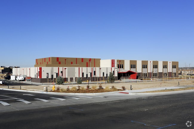

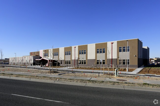

Property Detail
15035 Compark Blvd
Denver-Aurora-Centennial, CO
LOT 9B-1-A COMPARK VILLAGE 10 7.212 AM/L
2233-061-03-033
DOUGLAS
Publicschool
Colorado
B and X Area of moderate flood hazard, usually the area between the limits of the 100-year and 500-year floods.
9b,9b
0
7.21 AC
2025
Centennial
014014
Denver
54,900 SF
NEARBY LISTINGS FOR SALE OR LEASE
DEMOGRAPHICS near 15035 Compark Blvd
1 mile
3 mile
5 mile
2025 Total Population
7,813
62,036
186,174
2030 Population
8,364
66,059
195,204
Pop Growth 2025-2030
+ 7.05%
+ 6.48%
+ 4.85%
Average Age
37
37
39
2025 Total Households
2,801
24,276
70,944
HH Growth 2025-2030
+ 7.14%
+ 6.93%
+ 5.26%
Median Household Inc
$123,815
$111,068
$123,377
Avg Household Size
2.70
2.50
2.60
2025 Avg HH Vehicles
2.00
2.00
2.00
Median Home Value
$600,550
$673,425
$727,178
Median Year Built
2002
2005
2001
Nearby Places
Map Layers
Map Styles
 Street
 Aerial
Transit
 Traffic
 Biking
Places
Listings with unknown addresses are not visible on the map
- Restaurants
- Banks
- Shops
- Fitness
- Groceries
PUBLIC TRANSPORTATION
AIRPORT
Denver International
Drive
Walk
Distance
Denver International
34 min
30.8 mi
Freight Ports
Tulsa Port Of Catoosa
Drive
Walk
Distance
Tulsa Port Of Catoosa
727 min
710.7 mi
SALE & LEASE HISTORY
LISTING DATE
SALE/LEASE

May 06, 2019
For Lease
Nearby Properties
Address
Land Use
TOTAL SIZE
Lot Size
Zoning
Address
Land Use
TOTAL SIZE
Lot Size
Zoning
381,657 SF
33.84 AC
Address
Land Use
TOTAL SIZE
Lot Size
Zoning
280,586 SF
60.97 AC
RPD
Address
Land Use
TOTAL SIZE
Lot Size
Zoning
29,070 SF
308.89 AC
Address
Land Use
TOTAL SIZE
Lot Size
Zoning
284,862 SF
23.37 AC
PUD
Address
Land Use
TOTAL SIZE
Lot Size
Zoning
246,768 SF
12.37 AC
PUD
Address
Land Use
TOTAL SIZE
Lot Size
Zoning
134,316 SF
26.52 AC
Address
Land Use
TOTAL SIZE
Lot Size
Zoning
621,565 SF
32.64 AC
PDU
Address
Land Use
TOTAL SIZE
Lot Size
Zoning
304,620 SF
23.95 AC
AMU
Address
Land Use
TOTAL SIZE
Lot Size
Zoning
231,715 SF
5.58 AC
Address
Land Use
TOTAL SIZE
Lot Size
Zoning
107,760 SF
5.41 AC
AMU
Address
Land Use
TOTAL SIZE
Lot Size
Zoning
355,326 SF
12.27 AC
PUD
Address
Land Use
TOTAL SIZE
Lot Size
Zoning
253,296 SF
16.41 AC
Address
Land Use
TOTAL SIZE
Lot Size
Zoning
494,862 SF
30.59 AC
PDU
Address
Land Use
TOTAL SIZE
Lot Size
Zoning
441,689 SF
25.31 AC
Address
Land Use
TOTAL SIZE
Lot Size
Zoning
222,931 SF
13 AC
Address
Land Use
TOTAL SIZE
Lot Size
Zoning
632,485 SF
38.43 AC
PDU
Address
Land Use
TOTAL SIZE
Lot Size
Zoning
217,273 SF
18.28 AC
Address
Land Use
TOTAL SIZE
Lot Size
Zoning
171,600 SF
10.32 AC
AA2
Address
Land Use
TOTAL SIZE
Lot Size
Zoning
195,390 SF
14.78 AC
AI1
Address
Land Use
TOTAL SIZE
Lot Size
Zoning
281,429 SF
22.55 AC
PUD
Address
Land Use
TOTAL SIZE
Lot Size
Zoning
207,872 SF
44.94 AC
PDU
Address
Land Use
TOTAL SIZE
Lot Size
Zoning
494,489 SF
22.16 AC
Address
Land Use
TOTAL SIZE
Lot Size
Zoning
122,017 SF
11.39 AC
PDU
Address
Land Use
TOTAL SIZE
Lot Size
Zoning
150,920 SF
12.18 AC
AA1
Address
Land Use
TOTAL SIZE
Lot Size
Zoning
140,080 SF
15.05 AC
Address
Land Use
TOTAL SIZE
Lot Size
Zoning
91.37 AC
Address
Land Use
TOTAL SIZE
Lot Size
Zoning
190,344 SF
10.77 AC
PDU
Address
Land Use
TOTAL SIZE
Lot Size
Zoning
196,252 SF
17.14 AC
PDU
Address
Land Use
TOTAL SIZE
Lot Size
Zoning
149,928 SF
10.73 AC
Address
Land Use
TOTAL SIZE
Lot Size
Zoning
166,431 SF
19.37 AC
The World's #1 Commercial Real Estate Marketplace
Connect with us
© 2026 CoStar Group
The information above has been obtained from sources believed reliable. While we do not doubt its accuracy we have not verified it and make no guarantee, warranty or representation about it. It is your responsibility to independently confirm its accuracy and completeness. Any projections, opinions, assumptions, or estimates used are for example only and do not represent the current or future performance of the property. The value of this transaction to you depends on tax and other factors which should be evaluated by your tax, financial, and legal advisors. You and your advisors should conduct a careful, independent investigation of the property to determine to your satisfaction the suitability of the property for your needs.