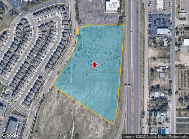
Property Record
1504 Ella Vw, Colorado Springs, CO 80915
NEARBY LISTINGS FOR SALE OR LEASE
Property Detail
1504 Ella Vw
Colorado Springs
Patriot Park Sub. Fil. No. 7
Colorado Springs, CO
LOT 1 PATRIOT PARK SUB. FIL. NO. 7
64124-02-008
El Paso
Commercialacreage
Colorado
2024
1
2025
10.43 AC
005000
Rustic Hills
DEMOGRAPHICS near 1504 Ella Vw
1 Mile
3 Mile
5 Mile
2024 Total Population
5,212
93,383
229,376
2029 Population
5,518
97,647
239,343
Pop Growth 2024-2029
+ 5.87%
+ 4.57%
+ 4.35%
Average Age
36
36
37
2024 Total Households
2,136
36,093
89,934
HH Growth 2024-2029
+ 6.27%
+ 4.89%
+ 4.63%
Median Household Inc
$57,894
$63,105
$64,311
Avg Household Size
2.40
2.50
2.50
2024 Avg HH Vehicles
2.00
2.00
2.00
Median Home Value
$296,225
$310,232
$326,840
Median Year Built
1977
1979
1980
Nearby Places
Map Layers
Map Styles
 Street
 Aerial
- Restaurants
- Banks
- Shops
- Fitness
- Groceries
PUBLIC TRANSPORTATION
AIRPORT
City of Colorado Springs Municipal
DRIVE
WALK
Distance
City of Colorado Springs Municipal
10 min
4.2 mi
Freight Ports
Tulsa Port Of Catoosa
DRIVE
WALK
Distance
Tulsa Port Of Catoosa
734 min
689.6 mi
Nearby Properties
Address
Land Use
TOTAL SIZE
Lot Size
Zoning
Address
Land Use
TOTAL SIZE
Lot Size
Zoning
8,806 SF
124.24 AC
PZ
Address
Land Use
TOTAL SIZE
Lot Size
Zoning
229,081 SF
9.87 AC
MX-N CU SS
Address
Land Use
TOTAL SIZE
Lot Size
Zoning
200,642 SF
6.65 AC
MX-M HR AO
Address
Land Use
TOTAL SIZE
Lot Size
Zoning
117,648 SF
3,971.89 AC
APD
Address
Land Use
TOTAL SIZE
Lot Size
Zoning
131,545 SF
12.46 AC
R-5/CR CU
Address
Land Use
TOTAL SIZE
Lot Size
Zoning
138,773 SF
4.45 AC
R-5
Address
Land Use
TOTAL SIZE
Lot Size
Zoning
87,577 SF
14.24 AC
CS CAD-O
Address
Land Use
TOTAL SIZE
Lot Size
Zoning
8,096 SF
123.01 AC
PF APZ2 AO
Address
Land Use
TOTAL SIZE
Lot Size
Zoning
86,290 SF
8.01 AC
I-2 CAD-O
Address
Land Use
TOTAL SIZE
Lot Size
Zoning
98,638 SF
7.22 AC
MX-M AO
Address
Land Use
TOTAL SIZE
Lot Size
Zoning
23,535 SF
15.91 AC
BP/CR AO
Address
Land Use
TOTAL SIZE
Lot Size
Zoning
76,203 SF
8.15 AC
PF
Address
Land Use
TOTAL SIZE
Lot Size
Zoning
60,324 SF
1.72 AC
R-5
Address
Land Use
TOTAL SIZE
Lot Size
Zoning
92,568 SF
11.08 AC
MX-M/CR
Address
Land Use
TOTAL SIZE
Lot Size
Zoning
45,328 SF
3.87 AC
R-4 CAD-O
Address
Land Use
TOTAL SIZE
Lot Size
Zoning
32,987 SF
6.55 AC
R-5/CR AO
Address
Land Use
TOTAL SIZE
Lot Size
Zoning
185,508 SF
16.48 AC
BP/CR AO S
Address
Land Use
TOTAL SIZE
Lot Size
Zoning
72,105 SF
11.32 AC
MX-T AO
Address
Land Use
TOTAL SIZE
Lot Size
Zoning
45,579 SF
4.50 AC
MX-M AO
Address
Land Use
TOTAL SIZE
Lot Size
Zoning
18,277 SF
5.80 AC
MX-M AO
Address
Land Use
TOTAL SIZE
Lot Size
Zoning
24,437 SF
4.78 AC
BP/CR AO
Address
Land Use
TOTAL SIZE
Lot Size
Zoning
52,145 SF
4.09 AC
R-1 6 CU
Address
Land Use
TOTAL SIZE
Lot Size
Zoning
40,920 SF
2.06 AC
R-5
Address
Land Use
TOTAL SIZE
Lot Size
Zoning
190,162 SF
15.06 AC
MX-M P AO
Address
Land Use
TOTAL SIZE
Lot Size
Zoning
109,042 SF
15.56 AC
UNK
Address
Land Use
TOTAL SIZE
Lot Size
Zoning
210,964 SF
27.40 AC
BP APZ1 AO
Address
Land Use
TOTAL SIZE
Lot Size
Zoning
50,040 SF
8 AC
R-1 6 AO
Address
Land Use
TOTAL SIZE
Lot Size
Zoning
188,859 SF
19.41 AC
M1
Address
Land Use
TOTAL SIZE
Lot Size
Zoning
96,849 SF
17.64 AC
R-1 6
Address
Land Use
TOTAL SIZE
Lot Size
Zoning
327,692 SF
16.30 AC
MX-N APZ2
The World's #1 Commercial Real Estate Marketplace
Connect with us
© 2025 CoStar Group
The information above has been obtained from sources believed reliable. While we do not doubt its accuracy we have not verified it and make no guarantee, warranty or representation about it. It is your responsibility to independently confirm its accuracy and completeness. Any projections, opinions, assumptions, or estimates used are for example only and do not represent the current or future performance of the property. The value of this transaction to you depends on tax and other factors which should be evaluated by your tax, financial, and legal advisors. You and your advisors should conduct a careful, independent investigation of the property to determine to your satisfaction the suitability of the property for your needs.