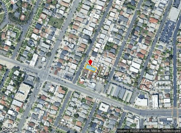
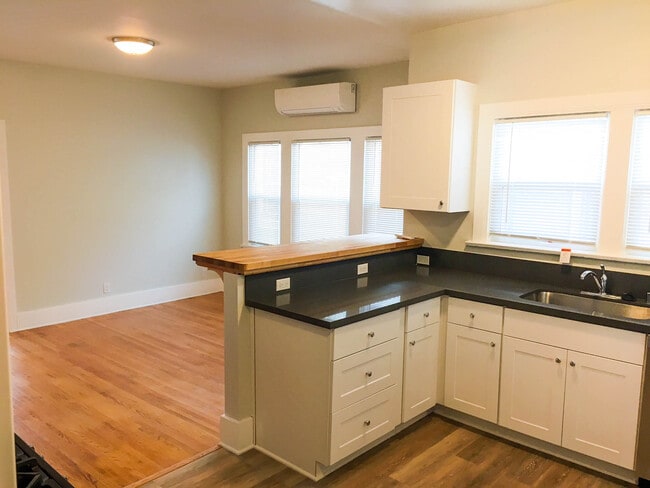
Property Record
1504 S Bronson Ave, Los Angeles, CA 90019
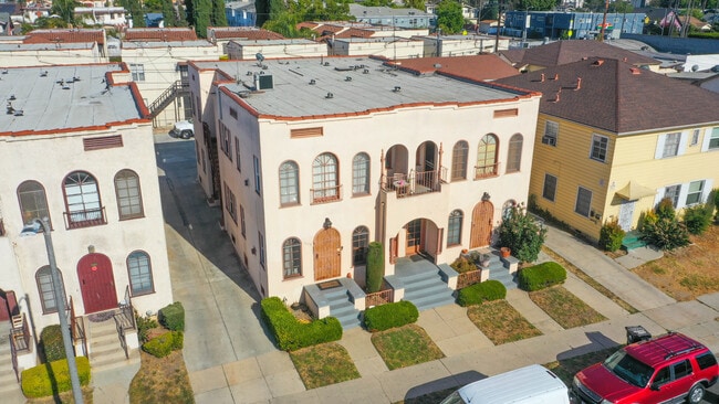

This Property Is For Sale
NEARBY LISTINGS FOR SALE OR LEASE
Property Detail
1504 S Bronson Ave
Los Angeles-Long Beach-Glendale, CA
4465
5072-007-008
TRACT NO.4465 LOT 21
Quadruplex
Los Angeles
X
California
06037C1612G
21
2025
0.13 AC
2025
Arlington Heights
218110
Los Angeles
4,380 SF
DEMOGRAPHICS near 1504 S Bronson Ave
1 Mile
3 Mile
5 Mile
2024 Total Population
50,663
527,896
1,272,782
2029 Population
49,129
515,221
1,239,828
Pop Growth 2024-2029
(3.03%)
(2.40%)
(2.59%)
Average Age
40
39
39
2024 Total Households
17,835
206,552
520,835
HH Growth 2024-2029
(3.30%)
(2.52%)
(2.51%)
Median Household Inc
$54,363
$54,771
$61,569
Avg Household Size
2.70
2.40
2.30
2024 Avg HH Vehicles
2.00
1.00
1.00
Median Home Value
$1,040,041
$929,766
$953,451
Median Year Built
1948
1954
1959
Nearby Places
- Restaurants
- Banks
- Shops
- Fitness
- Groceries
PUBLIC TRANSPORTATION
COMMUTER RAIL
Los Angeles (Coast Starlight - Amtrak, Pacific Surfliner - Amtrak, Southwest Chief - Amtrak, Texas Eagle - Amtrak)
DRIVE
WALK
Distance
Los Angeles (Coast Starlight - Amtrak, Pacific Surfliner - Amtrak, Southwest Chief - Amtrak, Texas Eagle - Amtrak)
12 min
6.7 mi
Union Station (91 Line - Southern California Regional Rail Authority (Metrolink), Antelope Valley Line - Southern California Regional Rail Authority (Metrolink), Orange County Line - Southern California Regional Rail Authority (Metrolink), Riverside Line - Southern California Regional Rail Authority (Metrolink), San Bernardino Line - Southern California Regional Rail Authority (Metrolink), Ventura County Line - Southern California Regional Rail Authority (Metrolink))
DRIVE
WALK
Distance
Union Station (91 Line - Southern California Regional Rail Authority (Metrolink), Antelope Valley Line - Southern California Regional Rail Authority (Metrolink), Orange County Line - Southern California Regional Rail Authority (Metrolink), Riverside Line - Southern California Regional Rail Authority (Metrolink), San Bernardino Line - Southern California Regional Rail Authority (Metrolink), Ventura County Line - Southern California Regional Rail Authority (Metrolink))
14 min
7.0 mi
AIRPORT
Los Angeles International
DRIVE
WALK
Distance
Los Angeles International
19 min
10.1 mi
Bob Hope
DRIVE
WALK
Distance
Bob Hope
24 min
13.9 mi
Long Beach (Daugherty Field)
DRIVE
WALK
Distance
Long Beach (Daugherty Field)
33 min
24.8 mi
Freight Ports
Port of Long Beach
DRIVE
WALK
Distance
Port of Long Beach
36 min
26.7 mi
Nearby Properties
Address
Land Use
TOTAL SIZE
Lot Size
Zoning
Address
Land Use
TOTAL SIZE
Lot Size
Zoning
969,516 SF
14.75 AC
Address
Land Use
TOTAL SIZE
Lot Size
Zoning
1,002,990 SF
8.42 AC
LAC4
Address
Land Use
TOTAL SIZE
Lot Size
Zoning
252,523 SF
2.26 AC
LAC2
Address
Land Use
TOTAL SIZE
Lot Size
Zoning
871,235 SF
14.56 AC
LAC2
Address
Land Use
TOTAL SIZE
Lot Size
Zoning
476,779 SF
1.57 AC
LAC4
Address
Land Use
TOTAL SIZE
Lot Size
Zoning
728,063 SF
2.08 AC
LAC4
Address
Land Use
TOTAL SIZE
Lot Size
Zoning
67,126 SF
48.09 AC
LAM1
Address
Land Use
TOTAL SIZE
Lot Size
Zoning
472,363 SF
3.24 AC
LAC4
Address
Land Use
TOTAL SIZE
Lot Size
Zoning
515,531 SF
14.65 AC
LAC2
Address
Land Use
TOTAL SIZE
Lot Size
Zoning
641,453 SF
2.93 AC
LAC4
Address
Land Use
TOTAL SIZE
Lot Size
Zoning
368,411 SF
10.91 AC
C2-2D-CPIO
Address
Land Use
TOTAL SIZE
Lot Size
Zoning
793,274 SF
7.80 AC
LAR4
Address
Land Use
TOTAL SIZE
Lot Size
Zoning
23,312 SF
11.08 AC
C2-2D-CPIO
Address
Land Use
TOTAL SIZE
Lot Size
Zoning
110,580 SF
6.88 AC
LAC2
Address
Land Use
TOTAL SIZE
Lot Size
Zoning
200,689 SF
5.79 AC
LAUSC-1A
Address
Land Use
TOTAL SIZE
Lot Size
Zoning
520,825 SF
2.13 AC
LAC2
Address
Land Use
TOTAL SIZE
Lot Size
Zoning
453,182 SF
2.76 AC
LAC4
Address
Land Use
TOTAL SIZE
Lot Size
Zoning
337,025 SF
14.59 AC
LAUSC-1A
Address
Land Use
TOTAL SIZE
Lot Size
Zoning
666,499 SF
10.63 AC
LAC2
Address
Land Use
TOTAL SIZE
Lot Size
Zoning
8.93 AC
LAC2
Address
Land Use
TOTAL SIZE
Lot Size
Zoning
679,557 SF
6.41 AC
LAC2
Address
Land Use
TOTAL SIZE
Lot Size
Zoning
786,423 SF
11.74 AC
LAC2
Address
Land Use
TOTAL SIZE
Lot Size
Zoning
341,221 SF
1.84 AC
LAC4
Address
Land Use
TOTAL SIZE
Lot Size
Zoning
78,793 SF
3.53 AC
LAMR1
Address
Land Use
TOTAL SIZE
Lot Size
Zoning
216,433 SF
1.38 AC
LAR5
Address
Land Use
TOTAL SIZE
Lot Size
Zoning
417,118 SF
1.58 AC
LAC4
Address
Land Use
TOTAL SIZE
Lot Size
Zoning
310,063 SF
2.22 AC
LAC2
Address
Land Use
TOTAL SIZE
Lot Size
Zoning
93,785 SF
3.95 AC
LAR5
Address
Land Use
TOTAL SIZE
Lot Size
Zoning
200,893 SF
1 AC
LAC4
Address
Land Use
TOTAL SIZE
Lot Size
Zoning
377,946 SF
5.03 AC
LAUSC-1A
The World's #1 Commercial Real Estate Marketplace
Connect with us
© 2025 CoStar Group
The information above has been obtained from sources believed reliable. While we do not doubt its accuracy we have not verified it and make no guarantee, warranty or representation about it. It is your responsibility to independently confirm its accuracy and completeness. Any projections, opinions, assumptions, or estimates used are for example only and do not represent the current or future performance of the property. The value of this transaction to you depends on tax and other factors which should be evaluated by your tax, financial, and legal advisors. You and your advisors should conduct a careful, independent investigation of the property to determine to your satisfaction the suitability of the property for your needs.