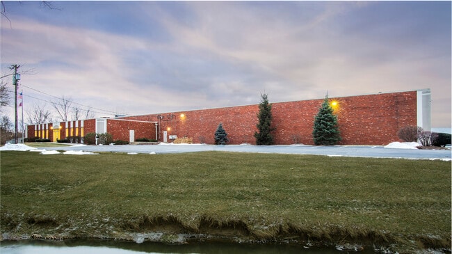
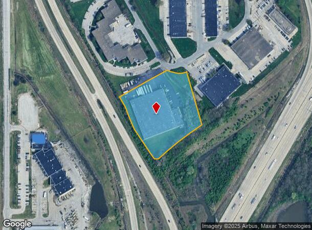
Property Record
1504 S Sadlier Cir, Indianapolis, IN 46239

NEARBY LISTINGS FOR SALE OR LEASE
Property Detail
1504 S Sadlier Cir
49-10-13-111-021.000-700
WRLY 119.27' SW 321.82'SE 67.19' SE 144.9' SE 206.28' TO BEG 3.551 AC
Warehouse
Marion
AE
Indiana
18097C0256F
c,b
2023
3.55 AC
2024
Warren Park
390200
Indianapolis
54,094 SF
Indianapolis-Carmel-Anderson, IN
DEMOGRAPHICS near 1504 S Sadlier Cir
1 Mile
3 Mile
5 Mile
2024 Total Population
3,595
49,887
188,195
2029 Population
3,527
49,124
186,692
Pop Growth 2024-2029
(1.89%)
(1.53%)
(0.80%)
Average Age
36
38
37
2024 Total Households
1,402
19,945
73,904
HH Growth 2024-2029
(1.93%)
(1.54%)
(0.87%)
Median Household Inc
$53,797
$61,448
$55,082
Avg Household Size
2.60
2.40
2.50
2024 Avg HH Vehicles
2.00
2.00
2.00
Median Home Value
$187,861
$174,269
$162,450
Median Year Built
1988
1962
1963
Nearby Places
Map Layers
Map Styles
 Street
 Aerial
- Restaurants
- Banks
- Shops
- Fitness
- Groceries
PUBLIC TRANSPORTATION
COMMUTER RAIL
DRIVE
WALK
Distance
14 min
7.1 mi
AIRPORT
Indianapolis International
DRIVE
WALK
Distance
Indianapolis International
36 min
20.1 mi
SALE & LEASE HISTORY
LISTING DATE
SALE/LEASE

Sep 26, 2016
For Lease
Oct 31, 2016
For Lease
May 12, 2017
For Sale
Jul 25, 2017
For Sale
Nearby Properties
Address
Land Use
TOTAL SIZE
Lot Size
Zoning
Address
Land Use
TOTAL SIZE
Lot Size
Zoning
1,202,700 SF
77.25 AC
ZO01
Address
Land Use
TOTAL SIZE
Lot Size
Zoning
47.10 AC
ZO01
Address
Land Use
TOTAL SIZE
Lot Size
Zoning
584,250 SF
42.54 AC
ZO01
Address
Land Use
TOTAL SIZE
Lot Size
Zoning
9,888 SF
124.20 AC
ZO01
Address
Land Use
TOTAL SIZE
Lot Size
Zoning
3,902 SF
26.84 AC
ZO01
Address
Land Use
TOTAL SIZE
Lot Size
Zoning
768,000 SF
29.62 AC
ZO03
Address
Land Use
TOTAL SIZE
Lot Size
Zoning
405,664 SF
35.56 AC
ZO01
Address
Land Use
TOTAL SIZE
Lot Size
Zoning
3,132 SF
20.50 AC
Address
Land Use
TOTAL SIZE
Lot Size
Zoning
133,257 SF
93.03 AC
ZO01
Address
Land Use
TOTAL SIZE
Lot Size
Zoning
1,660 SF
15.01 AC
ZO01
Address
Land Use
TOTAL SIZE
Lot Size
Zoning
198,375 SF
24.52 AC
ZO01
Address
Land Use
TOTAL SIZE
Lot Size
Zoning
8,054 SF
20.62 AC
Address
Land Use
TOTAL SIZE
Lot Size
Zoning
5,560 SF
10.88 AC
ZO01
Address
Land Use
TOTAL SIZE
Lot Size
Zoning
1,575 SF
10.24 AC
Address
Land Use
TOTAL SIZE
Lot Size
Zoning
46,800 SF
49.64 AC
ZO01
Address
Land Use
TOTAL SIZE
Lot Size
Zoning
3,832 SF
12.77 AC
ZO01
Address
Land Use
TOTAL SIZE
Lot Size
Zoning
616,065 SF
51.20 AC
ZO01
Address
Land Use
TOTAL SIZE
Lot Size
Zoning
169,094 SF
10.43 AC
ZO01
Address
Land Use
TOTAL SIZE
Lot Size
Zoning
67,252 SF
7.50 AC
ZO01
Address
Land Use
TOTAL SIZE
Lot Size
Zoning
209,756 SF
12.33 AC
ZO01
Address
Land Use
TOTAL SIZE
Lot Size
Zoning
1,538 SF
14.49 AC
ZO01
Address
Land Use
TOTAL SIZE
Lot Size
Zoning
140,976 SF
15.46 AC
ZO01
Address
Land Use
TOTAL SIZE
Lot Size
Zoning
409,096 SF
26.01 AC
Address
Land Use
TOTAL SIZE
Lot Size
Zoning
113,863 SF
13.60 AC
Address
Land Use
TOTAL SIZE
Lot Size
Zoning
202,736 SF
20.85 AC
ZO01
Address
Land Use
TOTAL SIZE
Lot Size
Zoning
115,550 SF
11.58 AC
ZO01
Address
Land Use
TOTAL SIZE
Lot Size
Zoning
1,825,713 SF
147.81 AC
ZO01
Address
Land Use
TOTAL SIZE
Lot Size
Zoning
206,632 SF
20.33 AC
ZO01
Address
Land Use
TOTAL SIZE
Lot Size
Zoning
160,410 SF
13.71 AC
Address
Land Use
TOTAL SIZE
Lot Size
Zoning
240,380 SF
44.81 AC
ZO01
The World's #1 Commercial Real Estate Marketplace
Connect with us
© 2025 CoStar Group
The information above has been obtained from sources believed reliable. While we do not doubt its accuracy we have not verified it and make no guarantee, warranty or representation about it. It is your responsibility to independently confirm its accuracy and completeness. Any projections, opinions, assumptions, or estimates used are for example only and do not represent the current or future performance of the property. The value of this transaction to you depends on tax and other factors which should be evaluated by your tax, financial, and legal advisors. You and your advisors should conduct a careful, independent investigation of the property to determine to your satisfaction the suitability of the property for your needs.