Property Record
15040 Jats Dr, Brandy Station, VA 22714
NEARBY LISTINGS FOR SALE OR LEASE
-
-
View all Brandy Station listings for lease on LoopNet.com
Property Detail
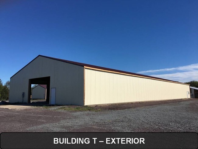
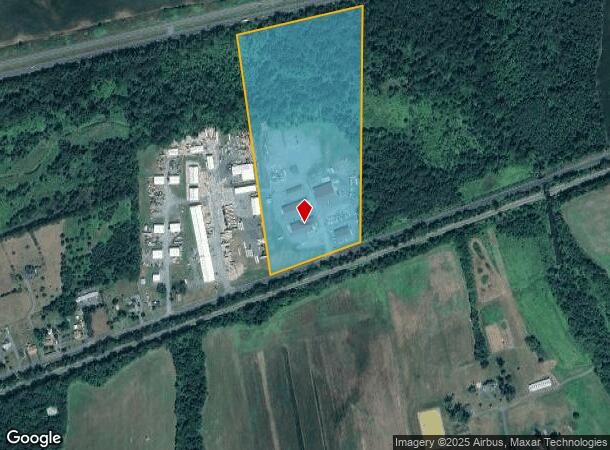
15040 Jats Dr
43-3-A2
TRACT C
Commercialnec
Culpeper
A
Virginia
51137C0025E
22.53 AC
2024
Suburban Virginia Area
2025
Other Market Areas
930400
Washington-Arlington-Alexandria, DC-VA-MD-WV
9,120 SF
DEMOGRAPHICS near 15040 Jats Dr
1 Mile
3 Mile
5 Mile
2024 Total Population
228
1,713
13,567
2029 Population
249
1,868
14,775
Pop Growth 2024-2029
+ 9.21%
+ 9.05%
+ 8.90%
Average Age
43
40
38
2024 Total Households
83
619
4,831
HH Growth 2024-2029
+ 9.64%
+ 9.05%
+ 9.09%
Median Household Inc
$76,250
$80,427
$81,731
Avg Household Size
2.60
2.70
2.70
2024 Avg HH Vehicles
3.00
2.00
2.00
Median Home Value
$350,000
$370,429
$329,208
Median Year Built
1986
1988
1988
Nearby Places
Map Layers
Map Styles
 Street
 Aerial
- Restaurants
- Banks
- Shops
- Fitness
- Groceries
PUBLIC TRANSPORTATION
COMMUTER RAIL
Culpeper Amtrak Station (Cardinal - Amtrak, Crescent - Amtrak, Northeast Regional - Amtrak)
DRIVE
WALK
Distance
Culpeper Amtrak Station (Cardinal - Amtrak, Crescent - Amtrak, Northeast Regional - Amtrak)
9 min
5.0 mi
Freight Ports
Virginia Port Authority - Richmond
DRIVE
WALK
Distance
Virginia Port Authority - Richmond
120 min
91.9 mi
SALE & LEASE HISTORY
LISTING DATE
SALE/LEASE

Nov 18, 2016
For Lease
Nearby Properties
Address
Land Use
TOTAL SIZE
Lot Size
Zoning
Address
Land Use
TOTAL SIZE
Lot Size
Zoning
25,802 SF
64.06 AC
A1
Address
Land Use
TOTAL SIZE
Lot Size
Zoning
1,527 SF
66.06 AC
A1
Address
Land Use
TOTAL SIZE
Lot Size
Zoning
2,559 SF
68.72 AC
HILI
Address
Land Use
TOTAL SIZE
Lot Size
Zoning
6,900 SF
4.14 AC
M2
Address
Land Use
TOTAL SIZE
Lot Size
Zoning
15,285 SF
2.40 AC
HI
Address
Land Use
TOTAL SIZE
Lot Size
Zoning
26,020 SF
13.42 AC
A1
Address
Land Use
TOTAL SIZE
Lot Size
Zoning
49.25 AC
HI
Address
Land Use
TOTAL SIZE
Lot Size
Zoning
4,500 SF
2.70 AC
M2
Address
Land Use
TOTAL SIZE
Lot Size
Zoning
21,420 SF
22.28 AC
RA
Address
Land Use
TOTAL SIZE
Lot Size
Zoning
4,953 SF
2.15 AC
HI
Address
Land Use
TOTAL SIZE
Lot Size
Zoning
5,840 SF
15 AC
RA
Address
Land Use
TOTAL SIZE
Lot Size
Zoning
32,000 SF
3.51 AC
M2
Address
Land Use
TOTAL SIZE
Lot Size
Zoning
9,226 SF
0.21 AC
HI
Address
Land Use
TOTAL SIZE
Lot Size
Zoning
4,400 SF
25.34 AC
M2
Address
Land Use
TOTAL SIZE
Lot Size
Zoning
1,920 SF
51.98 AC
RAHI
Address
Land Use
TOTAL SIZE
Lot Size
Zoning
4,132 SF
3.79 AC
HI
Address
Land Use
TOTAL SIZE
Lot Size
Zoning
2,600 SF
3.58 AC
M2
Address
Land Use
TOTAL SIZE
Lot Size
Zoning
2,688 SF
6.24 AC
HI
Address
Land Use
TOTAL SIZE
Lot Size
Zoning
24,000 SF
8.59 AC
HI
Address
Land Use
TOTAL SIZE
Lot Size
Zoning
4,800 SF
1.84 AC
M2
Address
Land Use
TOTAL SIZE
Lot Size
Zoning
14,945 SF
13.48 AC
LI
Address
Land Use
TOTAL SIZE
Lot Size
Zoning
13,200 SF
3.65 AC
HI
Address
Land Use
TOTAL SIZE
Lot Size
Zoning
6.33 AC
M2
Address
Land Use
TOTAL SIZE
Lot Size
Zoning
5,380 SF
0.12 AC
HI
Address
Land Use
TOTAL SIZE
Lot Size
Zoning
10,755 SF
17.04 AC
LI
Address
Land Use
TOTAL SIZE
Lot Size
Zoning
30,888 SF
2.72 AC
LI
Address
Land Use
TOTAL SIZE
Lot Size
Zoning
34.03 AC
LI
Address
Land Use
TOTAL SIZE
Lot Size
Zoning
12,620 SF
8.07 AC
R2
Address
Land Use
TOTAL SIZE
Lot Size
Zoning
6,099 SF
5.05 AC
HI
The World's #1 Commercial Real Estate Marketplace
Connect with us
© 2025 CoStar Group
The information above has been obtained from sources believed reliable. While we do not doubt its accuracy we have not verified it and make no guarantee, warranty or representation about it. It is your responsibility to independently confirm its accuracy and completeness. Any projections, opinions, assumptions, or estimates used are for example only and do not represent the current or future performance of the property. The value of this transaction to you depends on tax and other factors which should be evaluated by your tax, financial, and legal advisors. You and your advisors should conduct a careful, independent investigation of the property to determine to your satisfaction the suitability of the property for your needs.