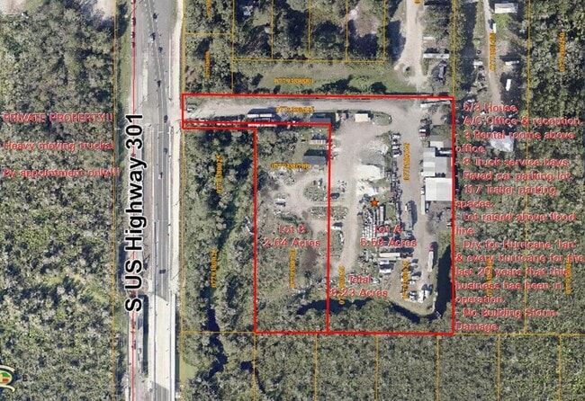
Property Record
15048 S 301 Hwy, Wimauma, FL 33598
NEARBY LISTINGS FOR SALE OR LEASE
Property Detail
15048 S 301 Hwy
Tampa-St. Petersburg-Clearwater, FL
Unplatted
U-29-31-20-ZZZ-000003-19170.0
SEC 29-31-20 W 532 FT OF S 565 FT OF S 1/2 OF NW 1/4 OF SW 1/4 LESS W 332 FT OF S 550 FT
Residentialacreage
Hillsborough
AE
Florida
12057C0515H
19170
2024
2.64 AC
2024
Eastern Outlying
013914
Tampa/St Petersburg
DEMOGRAPHICS near 15048 S 301 Hwy
1 Mile
3 Mile
5 Mile
2024 Total Population
8,291
62,679
144,347
2029 Population
9,320
70,435
161,182
Pop Growth 2024-2029
+ 12.41%
+ 12.37%
+ 11.66%
Average Age
40
41
42
2024 Total Households
2,917
22,483
53,444
HH Growth 2024-2029
+ 12.55%
+ 12.44%
+ 11.97%
Median Household Inc
$100,744
$86,921
$80,813
Avg Household Size
2.80
2.70
2.60
2024 Avg HH Vehicles
2.00
2.00
2.00
Median Home Value
$342,402
$294,435
$283,113
Median Year Built
2011
2010
2009
Nearby Places
Map Layers
Map Styles
 Street
 Aerial
- Restaurants
- Banks
- Shops
- Fitness
- Groceries
PUBLIC TRANSPORTATION
AIRPORT
Tampa International
DRIVE
WALK
Distance
Tampa International
44 min
29.0 mi
Sarasota/Bradenton International
DRIVE
WALK
Distance
Sarasota/Bradenton International
53 min
35.0 mi
St Pete-Clearwater International
DRIVE
WALK
Distance
St Pete-Clearwater International
61 min
38.2 mi
Freight Ports
Port of Tampa Bay
DRIVE
WALK
Distance
Port of Tampa Bay
31 min
18.6 mi
SALE & LEASE HISTORY
LISTING DATE
SALE/LEASE

Dec 01, 2022
For Sale
Nearby Properties
Address
Land Use
TOTAL SIZE
Lot Size
Zoning
Address
Land Use
TOTAL SIZE
Lot Size
Zoning
647,720 SF
68.52 AC
PD
Address
Land Use
TOTAL SIZE
Lot Size
Zoning
289,173 SF
54.08 AC
PD
Address
Land Use
TOTAL SIZE
Lot Size
Zoning
419,897 SF
18.09 AC
PD
Address
Land Use
TOTAL SIZE
Lot Size
Zoning
317,172 SF
36.54 AC
PD
Address
Land Use
TOTAL SIZE
Lot Size
Zoning
345,018 SF
15.43 AC
PD
Address
Land Use
TOTAL SIZE
Lot Size
Zoning
382,614 SF
23.72 AC
IPD-1
Address
Land Use
TOTAL SIZE
Lot Size
Zoning
334,871 SF
15 AC
PD
Address
Land Use
TOTAL SIZE
Lot Size
Zoning
154,232 SF
17.40 AC
PD
Address
Land Use
TOTAL SIZE
Lot Size
Zoning
1,583.93 AC
AR
Address
Land Use
TOTAL SIZE
Lot Size
Zoning
101,768 SF
17.94 AC
PD
Address
Land Use
TOTAL SIZE
Lot Size
Zoning
348,905 SF
20 AC
PD-MU
Address
Land Use
TOTAL SIZE
Lot Size
Zoning
138,397 SF
36.94 AC
PD
Address
Land Use
TOTAL SIZE
Lot Size
Zoning
102,925 SF
24.56 AC
PD
Address
Land Use
TOTAL SIZE
Lot Size
Zoning
211,729 SF
33.11 AC
PD
Address
Land Use
TOTAL SIZE
Lot Size
Zoning
92,585 SF
15.11 AC
PD
Address
Land Use
TOTAL SIZE
Lot Size
Zoning
68,942 SF
10.69 AC
PD
Address
Land Use
TOTAL SIZE
Lot Size
Zoning
113,296 SF
23.90 AC
PD
Address
Land Use
TOTAL SIZE
Lot Size
Zoning
75,207 SF
8.57 AC
PD
Address
Land Use
TOTAL SIZE
Lot Size
Zoning
81,193 SF
11.41 AC
PD
Address
Land Use
TOTAL SIZE
Lot Size
Zoning
138,316 SF
13.27 AC
PD
Address
Land Use
TOTAL SIZE
Lot Size
Zoning
75,710 SF
10.24 AC
PD
Address
Land Use
TOTAL SIZE
Lot Size
Zoning
113,683 SF
14.51 AC
PD
Address
Land Use
TOTAL SIZE
Lot Size
Zoning
629.86 AC
AR
Address
Land Use
TOTAL SIZE
Lot Size
Zoning
58,866 SF
1.80 AC
PD
Address
Land Use
TOTAL SIZE
Lot Size
Zoning
100,134 SF
10.45 AC
PD
Address
Land Use
TOTAL SIZE
Lot Size
Zoning
39,408 SF
5.77 AC
AR
Address
Land Use
TOTAL SIZE
Lot Size
Zoning
29,356 SF
2.79 AC
PD
Address
Land Use
TOTAL SIZE
Lot Size
Zoning
78,323 SF
7.19 AC
IPD-1
Address
Land Use
TOTAL SIZE
Lot Size
Zoning
36,426 SF
20.23 AC
PD
Address
Land Use
TOTAL SIZE
Lot Size
Zoning
43,597 SF
27.22 AC
AR
The World's #1 Commercial Real Estate Marketplace
Connect with us
© 2025 CoStar Group
The information above has been obtained from sources believed reliable. While we do not doubt its accuracy we have not verified it and make no guarantee, warranty or representation about it. It is your responsibility to independently confirm its accuracy and completeness. Any projections, opinions, assumptions, or estimates used are for example only and do not represent the current or future performance of the property. The value of this transaction to you depends on tax and other factors which should be evaluated by your tax, financial, and legal advisors. You and your advisors should conduct a careful, independent investigation of the property to determine to your satisfaction the suitability of the property for your needs.