Property Record
1505 Lexington Rd, Richmond, KY 40475


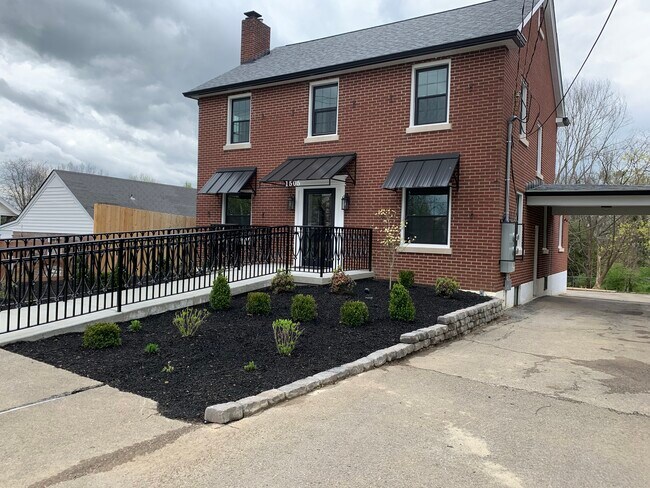
Property Detail
1505 Lexington Rd
Richmond-Berea, KY
BENNINGTON LOT 1 & 2 BLK A
R004-0002-0019
Madison
Medicalbuilding
Kentucky
B and X Area of moderate flood hazard, usually the area between the limits of the 100-year and 500-year floods.
1,2
2025
0.26 AC
2025
Georgetown/Richmond Area
010202
Other Market Areas
2,070 SF
NEARBY LISTINGS FOR SALE OR LEASE
DEMOGRAPHICS near 1505 Lexington Rd
1 mile
3 mile
5 mile
2025 Total Population
7,020
39,360
50,619
2030 Population
7,437
41,690
53,632
Pop Growth 2025-2030
+ 5.94%
+ 5.92%
+ 5.95%
Average Age
37
35
36
2025 Total Households
3,200
16,032
20,453
HH Growth 2025-2030
+ 6.28%
+ 6.37%
+ 6.39%
Median Household Inc
$53,889
$58,023
$63,412
Avg Household Size
2.10
2.20
2.20
2025 Avg HH Vehicles
2.00
2.00
2.00
Median Home Value
$184,714
$246,736
$265,789
Median Year Built
1981
1992
1993
Nearby Places
Map Layers
Map Styles
 Street
 Aerial
Transit
 Traffic
 Biking
Places
Listings with unknown addresses are not visible on the map
- Restaurants
- Banks
- Shops
- Fitness
- Groceries
PUBLIC TRANSPORTATION
AIRPORT
Blue Grass
Drive
Walk
Distance
Blue Grass
46 min
32.1 mi
Freight Ports
Port of Toledo
Drive
Walk
Distance
Port of Toledo
355 min
309.6 mi
SALE & LEASE HISTORY
LISTING DATE
SALE/LEASE

Apr 07, 2020
For Lease
Nearby Properties
Address
Land Use
TOTAL SIZE
Lot Size
Zoning
Address
Land Use
TOTAL SIZE
Lot Size
Zoning
13.91 AC
Address
Land Use
TOTAL SIZE
Lot Size
Zoning
21.81 AC
Address
Land Use
TOTAL SIZE
Lot Size
Zoning
10,400 SF
20.02 AC
Address
Land Use
TOTAL SIZE
Lot Size
Zoning
20.87 AC
Address
Land Use
TOTAL SIZE
Lot Size
Zoning
154,439 SF
23.52 AC
Address
Land Use
TOTAL SIZE
Lot Size
Zoning
195,345 SF
23.98 AC
Address
Land Use
TOTAL SIZE
Lot Size
Zoning
105,686 SF
10.34 AC
Address
Land Use
TOTAL SIZE
Lot Size
Zoning
5,776 SF
3.33 AC
Address
Land Use
TOTAL SIZE
Lot Size
Zoning
Address
Land Use
TOTAL SIZE
Lot Size
Zoning
11.05 AC
Address
Land Use
TOTAL SIZE
Lot Size
Zoning
5.61 AC
Address
Land Use
TOTAL SIZE
Lot Size
Zoning
8,520 SF
12.37 AC
Address
Land Use
TOTAL SIZE
Lot Size
Zoning
10,316 SF
5.87 AC
Address
Land Use
TOTAL SIZE
Lot Size
Zoning
10.84 AC
Address
Land Use
TOTAL SIZE
Lot Size
Zoning
Address
Land Use
TOTAL SIZE
Lot Size
Zoning
Address
Land Use
TOTAL SIZE
Lot Size
Zoning
121,085 SF
16.13 AC
Address
Land Use
TOTAL SIZE
Lot Size
Zoning
97,536 SF
8.62 AC
Address
Land Use
TOTAL SIZE
Lot Size
Zoning
28.07 AC
Address
Land Use
TOTAL SIZE
Lot Size
Zoning
228,982 SF
35.09 AC
Address
Land Use
TOTAL SIZE
Lot Size
Zoning
12,768 SF
5.28 AC
Address
Land Use
TOTAL SIZE
Lot Size
Zoning
77,081 SF
8.03 AC
Address
Land Use
TOTAL SIZE
Lot Size
Zoning
3,540 SF
5.05 AC
Address
Land Use
TOTAL SIZE
Lot Size
Zoning
2.17 AC
Address
Land Use
TOTAL SIZE
Lot Size
Zoning
Address
Land Use
TOTAL SIZE
Lot Size
Zoning
3.90 AC
Address
Land Use
TOTAL SIZE
Lot Size
Zoning
10,658 SF
1.65 AC
Address
Land Use
TOTAL SIZE
Lot Size
Zoning
1.56 AC
Address
Land Use
TOTAL SIZE
Lot Size
Zoning
44.67 AC
Address
Land Use
TOTAL SIZE
Lot Size
Zoning
68,042 SF
18.12 AC
The World's #1 Commercial Real Estate Marketplace
Connect with us
© 2026 CoStar Group
The information above has been obtained from sources believed reliable. While we do not doubt its accuracy we have not verified it and make no guarantee, warranty or representation about it. It is your responsibility to independently confirm its accuracy and completeness. Any projections, opinions, assumptions, or estimates used are for example only and do not represent the current or future performance of the property. The value of this transaction to you depends on tax and other factors which should be evaluated by your tax, financial, and legal advisors. You and your advisors should conduct a careful, independent investigation of the property to determine to your satisfaction the suitability of the property for your needs.