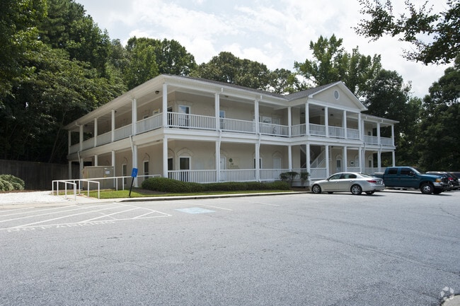
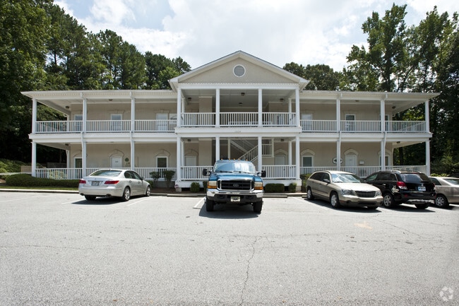
Property Record
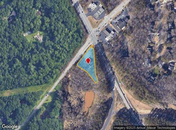
1505 Lilburn Stone Mountain Rd, Stone Mountain, GA 30087

Current Lease Availabilities
NEARBY LISTINGS FOR SALE OR LEASE
Property Detail
1505 Lilburn Stone Mountain Rd
18-135-05-001
284 X 13 X 20 X 29 X 298 X 70 X 25 X 160 X 110 X 39 0.85 10-5-92 273 X 15 X 20 X 29 X 288 X 69 X 25 X 160 X 110 X 39 1.059AC
Officebuilding
DeKalb
AE
Georgia
13089C0084K
1
2025
1.01 AC
2025
Stone Mountain
021912
Atlanta
13,248 SF
Atlanta-Sandy Springs-Roswell, GA
DEMOGRAPHICS near 1505 Lilburn Stone Mountain Rd
1 Mile
3 Mile
5 Mile
2024 Total Population
1,355
51,754
195,049
2029 Population
1,336
52,579
197,570
Pop Growth 2024-2029
(1.40%)
+ 1.59%
+ 1.29%
Average Age
50
39
39
2024 Total Households
523
19,317
68,408
HH Growth 2024-2029
(1.53%)
+ 1.50%
+ 1.20%
Median Household Inc
$153,947
$57,056
$66,291
Avg Household Size
2.60
2.60
2.80
2024 Avg HH Vehicles
3.00
2.00
2.00
Median Home Value
$433,642
$295,266
$265,956
Median Year Built
1979
1979
1981
Nearby Places
- Restaurants
- Banks
- Shops
- Fitness
- Groceries
PUBLIC TRANSPORTATION
AIRPORT
Hartsfield - Jackson Atlanta International
DRIVE
WALK
Distance
Hartsfield - Jackson Atlanta International
37 min
24.9 mi
Nearby Properties
Address
Land Use
TOTAL SIZE
Lot Size
Zoning
Address
Land Use
TOTAL SIZE
Lot Size
Zoning
Address
Land Use
TOTAL SIZE
Lot Size
Zoning
656,837 SF
88.74 AC
RM100
Address
Land Use
TOTAL SIZE
Lot Size
Zoning
2,682,168 SF
80.24 AC
M1
Address
Land Use
TOTAL SIZE
Lot Size
Zoning
232,617 SF
19.61 AC
RM
Address
Land Use
TOTAL SIZE
Lot Size
Zoning
307,313 SF
15.60 AC
RM24
Address
Land Use
TOTAL SIZE
Lot Size
Zoning
388,696 SF
13.89 AC
RM100
Address
Land Use
TOTAL SIZE
Lot Size
Zoning
339,612 SF
38.64 AC
C2
Address
Land Use
TOTAL SIZE
Lot Size
Zoning
339,262 SF
26.16 AC
RM100
Address
Land Use
TOTAL SIZE
Lot Size
Zoning
335,605 SF
20.22 AC
RM100
Address
Land Use
TOTAL SIZE
Lot Size
Zoning
224,812 SF
19.29 AC
RM75
Address
Land Use
TOTAL SIZE
Lot Size
Zoning
358,818 SF
22.41 AC
RM100
Address
Land Use
TOTAL SIZE
Lot Size
Zoning
249,184 SF
20 AC
RM100
Address
Land Use
TOTAL SIZE
Lot Size
Zoning
302,988 SF
41.36 AC
X
Address
Land Use
TOTAL SIZE
Lot Size
Zoning
292,996 SF
15.84 AC
RM100
Address
Land Use
TOTAL SIZE
Lot Size
Zoning
373,062 SF
20.59 AC
RM100
Address
Land Use
TOTAL SIZE
Lot Size
Zoning
324,116 SF
19.90 AC
A
Address
Land Use
TOTAL SIZE
Lot Size
Zoning
189,486 SF
18.57 AC
X
Address
Land Use
TOTAL SIZE
Lot Size
Zoning
490,343 SF
28.70 AC
X
Address
Land Use
TOTAL SIZE
Lot Size
Zoning
279,568 SF
0.15 AC
X
Address
Land Use
TOTAL SIZE
Lot Size
Zoning
331,031 SF
27.34 AC
RM100
Address
Land Use
TOTAL SIZE
Lot Size
Zoning
232,418 SF
21.57 AC
RM100
Address
Land Use
TOTAL SIZE
Lot Size
Zoning
34,138 SF
10.97 AC
MR1
Address
Land Use
TOTAL SIZE
Lot Size
Zoning
224,560 SF
12.89 AC
X
Address
Land Use
TOTAL SIZE
Lot Size
Zoning
192,072 SF
16.09 AC
X
Address
Land Use
TOTAL SIZE
Lot Size
Zoning
204,340 SF
19.86 AC
X
Address
Land Use
TOTAL SIZE
Lot Size
Zoning
189,380 SF
13.50 AC
X
Address
Land Use
TOTAL SIZE
Lot Size
Zoning
203,206 SF
15.66 AC
X
Address
Land Use
TOTAL SIZE
Lot Size
Zoning
160,943 SF
10.87 AC
X
Address
Land Use
TOTAL SIZE
Lot Size
Zoning
200,663 SF
11.73 AC
M
Address
Land Use
TOTAL SIZE
Lot Size
Zoning
163,200 SF
9 AC
RM75
The World's #1 Commercial Real Estate Marketplace
Connect with us
© 2025 CoStar Group
The information above has been obtained from sources believed reliable. While we do not doubt its accuracy we have not verified it and make no guarantee, warranty or representation about it. It is your responsibility to independently confirm its accuracy and completeness. Any projections, opinions, assumptions, or estimates used are for example only and do not represent the current or future performance of the property. The value of this transaction to you depends on tax and other factors which should be evaluated by your tax, financial, and legal advisors. You and your advisors should conduct a careful, independent investigation of the property to determine to your satisfaction the suitability of the property for your needs.