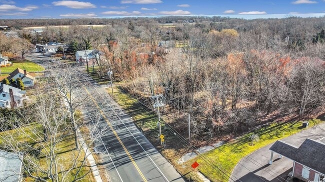
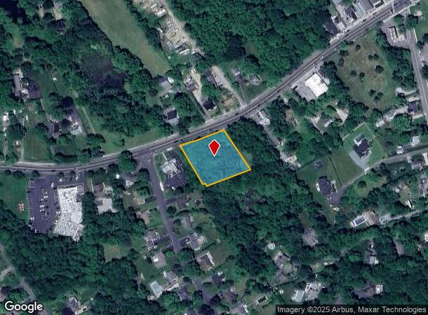
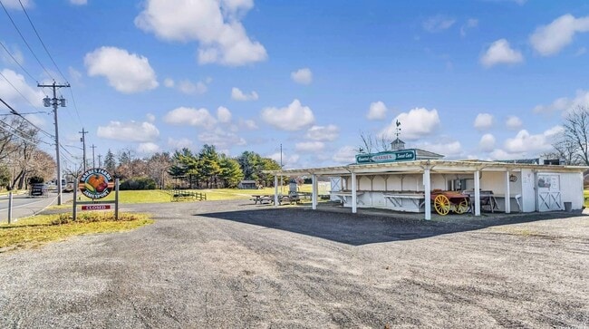
Property Record
1505 Main Rd, Laurel, NY 11948
NEARBY LISTINGS FOR SALE OR LEASE
Property Detail
1505 Main Rd
Nassau County-Suffolk County, NY
NX MAIN RD E& SX RDNOVCH W X NTH FRK BNK
0600-068-00-04-00-058-001
Suffolk
Commercialacreage
New York
X
58
36103C0479H
0.94 AC
2024
Eastern Suffolk
2024
Long Island (New York)
170003
DEMOGRAPHICS near 1505 Main Rd
1 Mile
3 Mile
5 Mile
2024 Total Population
1,180
6,822
31,549
2029 Population
1,102
6,701
31,524
Pop Growth 2024-2029
(6.61%)
(1.77%)
(0.08%)
Average Age
48
45
43
2024 Total Households
486
2,566
11,403
HH Growth 2024-2029
(7.20%)
(2.30%)
(0.33%)
Median Household Inc
$100,266
$112,161
$86,142
Avg Household Size
2.40
2.60
2.60
2024 Avg HH Vehicles
2.00
2.00
2.00
Median Home Value
$754,578
$701,510
$535,569
Median Year Built
1977
1978
1979
Nearby Places
- Restaurants
- Banks
- Shops
- Fitness
- Groceries
PUBLIC TRANSPORTATION
COMMUTER RAIL
Mattituck Station (Greenport Branch - Long Island Rail Road)
DRIVE
WALK
Distance
Mattituck Station (Greenport Branch - Long Island Rail Road)
7 min
4.2 mi
Riverhead Station (Greenport Branch - Long Island Rail Road)
DRIVE
WALK
Distance
Riverhead Station (Greenport Branch - Long Island Rail Road)
11 min
5.4 mi
AIRPORT
Long Island MacArthur
DRIVE
WALK
Distance
Long Island MacArthur
53 min
34.1 mi
Freight Ports
Port of New Haven
DRIVE
WALK
Distance
Port of New Haven
156 min
64.5 mi
SALE & LEASE HISTORY
LISTING DATE
SALE/LEASE
Jul 25, 2024
For Sale

Feb 14, 2022
For Sale
Nearby Properties
Address
Land Use
TOTAL SIZE
Lot Size
Zoning
Address
Land Use
TOTAL SIZE
Lot Size
Zoning
222 AC
H2O
Address
Land Use
TOTAL SIZE
Lot Size
Zoning
81.70 AC
R60
Address
Land Use
TOTAL SIZE
Lot Size
Zoning
13.29 AC
R80
Address
Land Use
TOTAL SIZE
Lot Size
Zoning
113,634 SF
27.49 AC
04
Address
Land Use
TOTAL SIZE
Lot Size
Zoning
274.40 AC
05
Address
Land Use
TOTAL SIZE
Lot Size
Zoning
4.20 AC
R10
Address
Land Use
TOTAL SIZE
Lot Size
Zoning
197.40 AC
OSC
Address
Land Use
TOTAL SIZE
Lot Size
Zoning
2.33 AC
R40
Address
Land Use
TOTAL SIZE
Lot Size
Zoning
3,152 SF
1.03 AC
R40
Address
Land Use
TOTAL SIZE
Lot Size
Zoning
19 AC
H2O
Address
Land Use
TOTAL SIZE
Lot Size
Zoning
1,688 SF
34.47 AC
09
Address
Land Use
TOTAL SIZE
Lot Size
Zoning
5.01 AC
10
Address
Land Use
TOTAL SIZE
Lot Size
Zoning
4,092 SF
5.21 AC
03
Address
Land Use
TOTAL SIZE
Lot Size
Zoning
15,996 SF
6.05 AC
3
Address
Land Use
TOTAL SIZE
Lot Size
Zoning
5,338 SF
159.30 AC
4
Address
Land Use
TOTAL SIZE
Lot Size
Zoning
172.90 AC
RA80
Address
Land Use
TOTAL SIZE
Lot Size
Zoning
94.60 AC
04
Address
Land Use
TOTAL SIZE
Lot Size
Zoning
700 SF
5 AC
R60
Address
Land Use
TOTAL SIZE
Lot Size
Zoning
2,600 SF
27.30 AC
RB80
Address
Land Use
TOTAL SIZE
Lot Size
Zoning
11.39 AC
10
Address
Land Use
TOTAL SIZE
Lot Size
Zoning
1,980 SF
63.11 AC
09
Address
Land Use
TOTAL SIZE
Lot Size
Zoning
13,943 SF
4.40 AC
04
Address
Land Use
TOTAL SIZE
Lot Size
Zoning
6,000 SF
3.60 AC
04
Address
Land Use
TOTAL SIZE
Lot Size
Zoning
2,928 SF
85.90 AC
04
Address
Land Use
TOTAL SIZE
Lot Size
Zoning
10,876 SF
4.80 AC
04
Address
Land Use
TOTAL SIZE
Lot Size
Zoning
1,396 SF
1.51 AC
R10
Address
Land Use
TOTAL SIZE
Lot Size
Zoning
0.92 AC
R40
Address
Land Use
TOTAL SIZE
Lot Size
Zoning
2,588 SF
107.80 AC
03
Address
Land Use
TOTAL SIZE
Lot Size
Zoning
8,891 SF
2.91 AC
4
Address
Land Use
TOTAL SIZE
Lot Size
Zoning
24,898 SF
3.80 AC
4
The World's #1 Commercial Real Estate Marketplace
Connect with us
© 2025 CoStar Group
The information above has been obtained from sources believed reliable. While we do not doubt its accuracy we have not verified it and make no guarantee, warranty or representation about it. It is your responsibility to independently confirm its accuracy and completeness. Any projections, opinions, assumptions, or estimates used are for example only and do not represent the current or future performance of the property. The value of this transaction to you depends on tax and other factors which should be evaluated by your tax, financial, and legal advisors. You and your advisors should conduct a careful, independent investigation of the property to determine to your satisfaction the suitability of the property for your needs.