Property Record
1505 Morningside Rd, Brownsville, TX 78521

NEARBY LISTINGS FOR SALE OR LEASE
-
-
View all Brownsville listings for sale on LoopNet.com
Property Detail
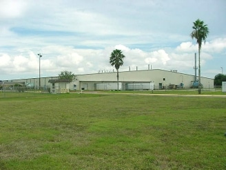
1505 Morningside Rd
742150-0060-000010
Chicago Gardens Subdivision
Industrialgeneral
CHICAGO GARDENS SUBDIVISION BLK 6, 40.000 ACRES
X
Cameron
48061C0595F
Texas
2024
39.75 AC
2025
Greater Brownsville
014300
Brownsville/Harlingen
191,664 SF
Brownsville-Harlingen, TX
DEMOGRAPHICS near 1505 Morningside Rd
1 Mile
3 Mile
5 Mile
2024 Total Population
7,609
70,048
129,713
2029 Population
7,845
72,325
133,412
Pop Growth 2024-2029
+ 3.10%
+ 3.25%
+ 2.85%
Average Age
36
35
35
2024 Total Households
2,208
20,230
39,824
HH Growth 2024-2029
+ 3.49%
+ 3.30%
+ 2.84%
Median Household Inc
$37,690
$35,655
$37,630
Avg Household Size
3.30
3.40
3.20
2024 Avg HH Vehicles
2.00
2.00
2.00
Median Home Value
$65,027
$67,033
$81,013
Median Year Built
1988
1990
1990
Nearby Places
Map Layers
Map Styles
 Street
 Aerial
- Restaurants
- Banks
- Shops
- Fitness
- Groceries
PUBLIC TRANSPORTATION
AIRPORT
Brownsville/South Padre Island International
DRIVE
WALK
Distance
Brownsville/South Padre Island International
3 min
1.0 mi
Valley International
DRIVE
WALK
Distance
Valley International
51 min
31.1 mi
Freight Ports
Port of Brownsville
DRIVE
WALK
Distance
Port of Brownsville
9 min
4.7 mi
Nearby Properties
Address
Land Use
TOTAL SIZE
Lot Size
Zoning
Address
Land Use
TOTAL SIZE
Lot Size
Zoning
328,021 SF
70.19 AC
SD6
Address
Land Use
TOTAL SIZE
Lot Size
Zoning
248,857 SF
37.16 AC
Address
Land Use
TOTAL SIZE
Lot Size
Zoning
167,737 SF
29.87 AC
Address
Land Use
TOTAL SIZE
Lot Size
Zoning
145,240 SF
17.49 AC
Address
Land Use
TOTAL SIZE
Lot Size
Zoning
132,197 SF
10.70 AC
Address
Land Use
TOTAL SIZE
Lot Size
Zoning
115,463 SF
22.09 AC
Address
Land Use
TOTAL SIZE
Lot Size
Zoning
88,591 SF
22 AC
SD6
Address
Land Use
TOTAL SIZE
Lot Size
Zoning
107,815 SF
10 AC
Address
Land Use
TOTAL SIZE
Lot Size
Zoning
87,909 SF
12 AC
Address
Land Use
TOTAL SIZE
Lot Size
Zoning
392,622 SF
55 AC
I
Address
Land Use
TOTAL SIZE
Lot Size
Zoning
238,221 SF
27.02 AC
Address
Land Use
TOTAL SIZE
Lot Size
Zoning
88,256 SF
18.16 AC
Address
Land Use
TOTAL SIZE
Lot Size
Zoning
195,810 SF
26.95 AC
Address
Land Use
TOTAL SIZE
Lot Size
Zoning
462.60 AC
Address
Land Use
TOTAL SIZE
Lot Size
Zoning
96,314 SF
6.77 AC
C
Address
Land Use
TOTAL SIZE
Lot Size
Zoning
102,316 SF
10.93 AC
Address
Land Use
TOTAL SIZE
Lot Size
Zoning
56,918 SF
2.95 AC
Address
Land Use
TOTAL SIZE
Lot Size
Zoning
85,803 SF
2.75 AC
Address
Land Use
TOTAL SIZE
Lot Size
Zoning
82,098 SF
20.25 AC
Address
Land Use
TOTAL SIZE
Lot Size
Zoning
151,872 SF
Address
Land Use
TOTAL SIZE
Lot Size
Zoning
189,213 SF
10.40 AC
C
Address
Land Use
TOTAL SIZE
Lot Size
Zoning
141,109 SF
7.34 AC
Address
Land Use
TOTAL SIZE
Lot Size
Zoning
53,035 SF
2 AC
Address
Land Use
TOTAL SIZE
Lot Size
Zoning
181,695 SF
19.67 AC
Address
Land Use
TOTAL SIZE
Lot Size
Zoning
75,196 SF
15.86 AC
Address
Land Use
TOTAL SIZE
Lot Size
Zoning
109,075 SF
10.45 AC
C
Address
Land Use
TOTAL SIZE
Lot Size
Zoning
48,760 SF
7 AC
C
Address
Land Use
TOTAL SIZE
Lot Size
Zoning
141,320 SF
10.01 AC
B
Address
Land Use
TOTAL SIZE
Lot Size
Zoning
130,292 SF
19.23 AC
The World's #1 Commercial Real Estate Marketplace
Connect with us
© 2025 CoStar Group
The information above has been obtained from sources believed reliable. While we do not doubt its accuracy we have not verified it and make no guarantee, warranty or representation about it. It is your responsibility to independently confirm its accuracy and completeness. Any projections, opinions, assumptions, or estimates used are for example only and do not represent the current or future performance of the property. The value of this transaction to you depends on tax and other factors which should be evaluated by your tax, financial, and legal advisors. You and your advisors should conduct a careful, independent investigation of the property to determine to your satisfaction the suitability of the property for your needs.