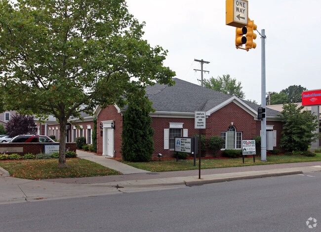
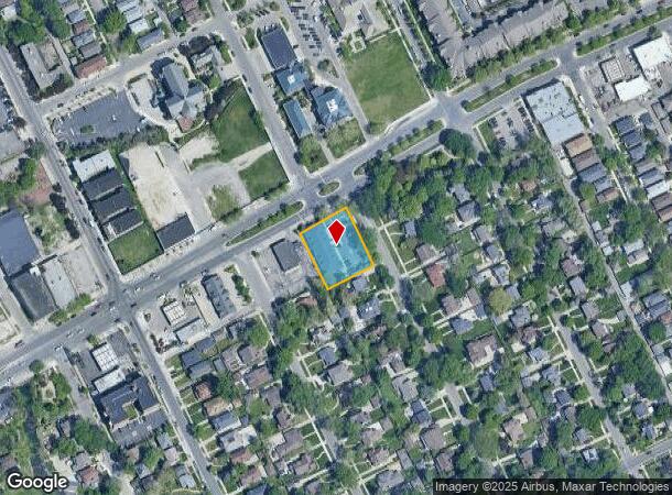
Property Record
15050 E Jefferson Ave, Grosse Pointe Park, MI 48230


NEARBY LISTINGS FOR SALE OR LEASE
Property Detail
15050 E Jefferson Ave
Detroit-Warren-Dearborn, MI
Windmill Pointe
39-009-02-0354-300
PKYY354,355 LOTS 354 AND 355 WINDMILL PTE SUB PC 126,127,379,570,696 L37 P5, 6 WCR
Medicalbuilding
Wayne
X
Michigan
26163C0140F
354-355
2024
0.51 AC
2025
The Pointes/Harper Woods
550100
Detroit
7,310 SF
DEMOGRAPHICS near 15050 E Jefferson Ave
1 Mile
3 Mile
5 Mile
2024 Total Population
14,716
79,794
195,683
2029 Population
14,501
79,294
195,882
Pop Growth 2024-2029
(1.46%)
(0.63%)
+ 0.10%
Average Age
41
39
39
2024 Total Households
6,168
31,602
77,849
HH Growth 2024-2029
(1.43%)
(0.74%)
(0.08%)
Median Household Inc
$73,573
$50,405
$45,278
Avg Household Size
2.30
2.40
2.40
2024 Avg HH Vehicles
2.00
1.00
1.00
Median Home Value
$326,866
$193,562
$129,736
Median Year Built
1947
1948
1949
Nearby Places
Map Layers
Map Styles
 Street
 Aerial
- Restaurants
- Banks
- Shops
- Fitness
- Groceries
PUBLIC TRANSPORTATION
COMMUTER RAIL
DRIVE
WALK
Distance
18 min
8.9 mi
DRIVE
WALK
Distance
25 min
9.7 mi
AIRPORT
Windsor International
DRIVE
WALK
Distance
Windsor International
38 min
15.6 mi
Detroit Metro Wayne County
DRIVE
WALK
Distance
Detroit Metro Wayne County
47 min
29.8 mi
SALE & LEASE HISTORY
LISTING DATE
SALE/LEASE

May 11, 2018
For Lease
Jan 23, 2017
For Lease
Dec 08, 2020
For Lease
Nearby Properties
Address
Land Use
TOTAL SIZE
Lot Size
Zoning
Address
Land Use
TOTAL SIZE
Lot Size
Zoning
2,958,207 SF
277.38 AC
M4
Address
Land Use
TOTAL SIZE
Lot Size
Zoning
2,005,073 SF
108.66 AC
M4
Address
Land Use
TOTAL SIZE
Lot Size
Zoning
461,840 SF
4.78 AC
R6
Address
Land Use
TOTAL SIZE
Lot Size
Zoning
929,400 SF
52.48 AC
M4
Address
Land Use
TOTAL SIZE
Lot Size
Zoning
482,649 SF
M4
Address
Land Use
TOTAL SIZE
Lot Size
Zoning
648,928 SF
5.46 AC
R6
Address
Land Use
TOTAL SIZE
Lot Size
Zoning
298,117 SF
15.97 AC
PD
Address
Land Use
TOTAL SIZE
Lot Size
Zoning
49,437 SF
0.47 AC
Address
Land Use
TOTAL SIZE
Lot Size
Zoning
57.16 AC
M4
Address
Land Use
TOTAL SIZE
Lot Size
Zoning
93,296 SF
1.05 AC
C-2
Address
Land Use
TOTAL SIZE
Lot Size
Zoning
62,195 SF
1.50 AC
Address
Land Use
TOTAL SIZE
Lot Size
Zoning
17,558 SF
3.15 AC
Address
Land Use
TOTAL SIZE
Lot Size
Zoning
41,000 SF
C-1
Address
Land Use
TOTAL SIZE
Lot Size
Zoning
89,897 SF
2.23 AC
Address
Land Use
TOTAL SIZE
Lot Size
Zoning
129,260 SF
3 AC
B4
Address
Land Use
TOTAL SIZE
Lot Size
Zoning
72,940 SF
83.37 AC
M4
Address
Land Use
TOTAL SIZE
Lot Size
Zoning
93,850 SF
6.56 AC
Address
Land Use
TOTAL SIZE
Lot Size
Zoning
88,695 SF
6.53 AC
PD
Address
Land Use
TOTAL SIZE
Lot Size
Zoning
115,839 SF
8.54 AC
M4
Address
Land Use
TOTAL SIZE
Lot Size
Zoning
28,055 SF
0.44 AC
Address
Land Use
TOTAL SIZE
Lot Size
Zoning
105,847 SF
2.28 AC
R5
Address
Land Use
TOTAL SIZE
Lot Size
Zoning
62,402 SF
0.28 AC
B4
Address
Land Use
TOTAL SIZE
Lot Size
Zoning
42,113 SF
0.54 AC
Address
Land Use
TOTAL SIZE
Lot Size
Zoning
24,826 SF
5.56 AC
B4
Address
Land Use
TOTAL SIZE
Lot Size
Zoning
77,196 SF
21.21 AC
M3
Address
Land Use
TOTAL SIZE
Lot Size
Zoning
20,625 SF
0.48 AC
C-2
Address
Land Use
TOTAL SIZE
Lot Size
Zoning
60,638 SF
0.27 AC
B4
Address
Land Use
TOTAL SIZE
Lot Size
Zoning
47,227 SF
6.29 AC
PD
Address
Land Use
TOTAL SIZE
Lot Size
Zoning
25,500 SF
0.23 AC
Address
Land Use
TOTAL SIZE
Lot Size
Zoning
60,484 SF
4.85 AC
PD
The World's #1 Commercial Real Estate Marketplace
Connect with us
© 2025 CoStar Group
The information above has been obtained from sources believed reliable. While we do not doubt its accuracy we have not verified it and make no guarantee, warranty or representation about it. It is your responsibility to independently confirm its accuracy and completeness. Any projections, opinions, assumptions, or estimates used are for example only and do not represent the current or future performance of the property. The value of this transaction to you depends on tax and other factors which should be evaluated by your tax, financial, and legal advisors. You and your advisors should conduct a careful, independent investigation of the property to determine to your satisfaction the suitability of the property for your needs.