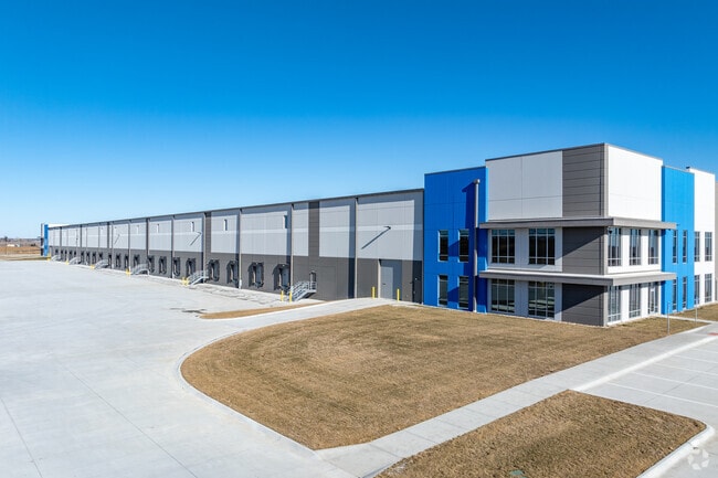
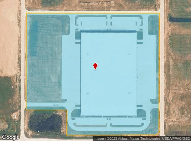
Property Record
15052 S 210Th St, , NE
NEARBY LISTINGS FOR SALE OR LEASE
Property Detail
15052 S 210Th St
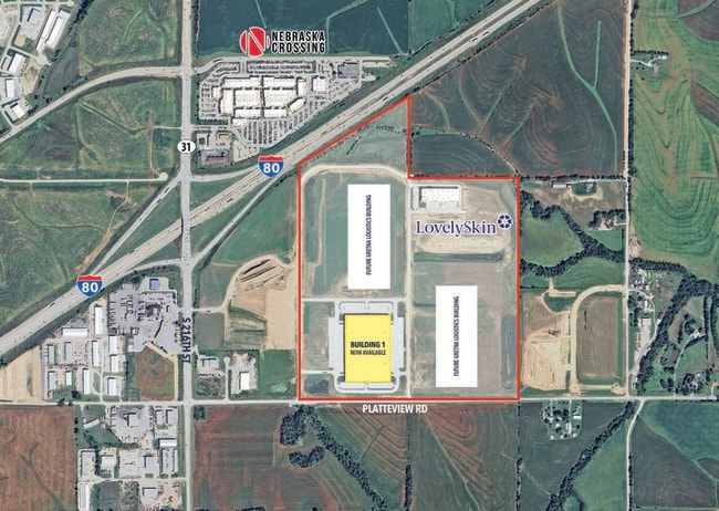
Sarpy West
Gretna Logistics Park
Omaha/Council Bluffs
LOT 1 GRETNA LOGISTICS PARK REPLAT 1 (30.871 AC)
Omaha-Council Bluffs, NE-IA
Sarpy
011614984
Nebraska
Industrialgeneral
1
2024
30.87 AC
2025
DEMOGRAPHICS near 15052 S 210Th St
1 Mile
3 Mile
5 Mile
2024 Total Population
104
3,969
15,428
2029 Population
110
4,299
16,865
Pop Growth 2024-2029
+ 5.77%
+ 8.31%
+ 9.31%
Average Age
40
37
37
2024 Total Households
35
1,283
5,254
HH Growth 2024-2029
+ 5.71%
+ 8.42%
+ 9.40%
Median Household Inc
$124,999
$124,355
$126,175
Avg Household Size
3.10
3.10
2.90
2024 Avg HH Vehicles
3.00
3.00
2.00
Median Home Value
$458,333
$381,271
$350,378
Median Year Built
1992
2001
2005
Nearby Places
Map Layers
Map Styles
 Street
 Aerial
- Restaurants
- Banks
- Shops
- Fitness
- Groceries
PUBLIC TRANSPORTATION
AIRPORT
Eppley Airfield
DRIVE
WALK
Distance
Eppley Airfield
37 min
27.5 mi
Freight Ports
Tulsa Port Of Catoosa
DRIVE
WALK
Distance
Tulsa Port Of Catoosa
471 min
422.5 mi
SALE & LEASE HISTORY
LISTING DATE
SALE/LEASE

Jan 04, 2023
For Lease
Nearby Properties
Address
Land Use
TOTAL SIZE
Lot Size
Zoning
Address
Land Use
TOTAL SIZE
Lot Size
Zoning
46,338 SF
25.95 AC
Address
Land Use
TOTAL SIZE
Lot Size
Zoning
1,288 SF
157.59 AC
AG
Address
Land Use
TOTAL SIZE
Lot Size
Zoning
15.85 AC
Address
Land Use
TOTAL SIZE
Lot Size
Zoning
37,589 SF
6.76 AC
Address
Land Use
TOTAL SIZE
Lot Size
Zoning
6.78 AC
Address
Land Use
TOTAL SIZE
Lot Size
Zoning
17,250 SF
10.21 AC
Address
Land Use
TOTAL SIZE
Lot Size
Zoning
1.65 AC
I1
Address
Land Use
TOTAL SIZE
Lot Size
Zoning
Address
Land Use
TOTAL SIZE
Lot Size
Zoning
5.33 AC
Address
Land Use
TOTAL SIZE
Lot Size
Zoning
32,763 SF
3 AC
Address
Land Use
TOTAL SIZE
Lot Size
Zoning
41,075 SF
1.04 AC
Address
Land Use
TOTAL SIZE
Lot Size
Zoning
66,758 SF
10.55 AC
I1
Address
Land Use
TOTAL SIZE
Lot Size
Zoning
11,836 SF
6.12 AC
Address
Land Use
TOTAL SIZE
Lot Size
Zoning
14,114 SF
2.80 AC
Address
Land Use
TOTAL SIZE
Lot Size
Zoning
20,400 SF
3.14 AC
Address
Land Use
TOTAL SIZE
Lot Size
Zoning
15,595 SF
12.24 AC
HC
Address
Land Use
TOTAL SIZE
Lot Size
Zoning
5,624 SF
196.87 AC
AG
Address
Land Use
TOTAL SIZE
Lot Size
Zoning
3.75 AC
Address
Land Use
TOTAL SIZE
Lot Size
Zoning
6,480 SF
0.13 AC
GC
Address
Land Use
TOTAL SIZE
Lot Size
Zoning
10,500 SF
3.44 AC
I1
Address
Land Use
TOTAL SIZE
Lot Size
Zoning
0.96 AC
Address
Land Use
TOTAL SIZE
Lot Size
Zoning
35.39 AC
GC
Address
Land Use
TOTAL SIZE
Lot Size
Zoning
27,244 SF
1.97 AC
Address
Land Use
TOTAL SIZE
Lot Size
Zoning
20,000 SF
1.72 AC
Address
Land Use
TOTAL SIZE
Lot Size
Zoning
10,451 SF
2.07 AC
Address
Land Use
TOTAL SIZE
Lot Size
Zoning
9,720 SF
1.44 AC
GC
Address
Land Use
TOTAL SIZE
Lot Size
Zoning
22,225 SF
2.99 AC
Address
Land Use
TOTAL SIZE
Lot Size
Zoning
9,486 SF
1.38 AC
Address
Land Use
TOTAL SIZE
Lot Size
Zoning
20,100 SF
1.50 AC
GC
The World's #1 Commercial Real Estate Marketplace
Connect with us
© 2025 CoStar Group
The information above has been obtained from sources believed reliable. While we do not doubt its accuracy we have not verified it and make no guarantee, warranty or representation about it. It is your responsibility to independently confirm its accuracy and completeness. Any projections, opinions, assumptions, or estimates used are for example only and do not represent the current or future performance of the property. The value of this transaction to you depends on tax and other factors which should be evaluated by your tax, financial, and legal advisors. You and your advisors should conduct a careful, independent investigation of the property to determine to your satisfaction the suitability of the property for your needs.