Property Record
15058 Balm Rd, Wimauma, FL 33598
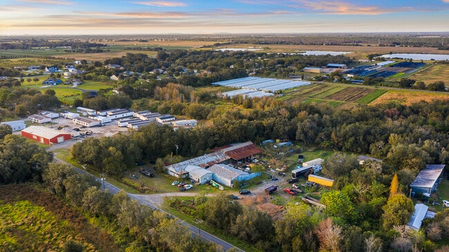


This Property Is For Sale
Property Detail
15058 Balm Rd
U-25-31-20-ZZZ-000003-17590.0
TRACT DESC AS FROM INTERS OF S BDRY OF NE 1/4 OF NW 1/4 AND C/L OF RR RUN E 550 FT N 400 FT W TO C/L OF RR AND SWLY ALONG C/L TO BEG AND LESS THAT PART DESCRIBED AS: COMM AT SE COR OF NE 1/4 OF NW 1/4 THN RUN S 89 DEG 59 MIN 43 SEC W 797.66 FT THN S
Shipyard
Hillsborough
CG
Florida
AE The base floodplain where base flood elevations are provided. AE Zones are now used on new format FIRMs instead of A1-A30 Zones.
17590
2024
2.40 AC
2025
Eastern Outlying
013907
Tampa/St Petersburg
960 SF
Tampa-St. Petersburg-Clearwater, FL
NEARBY LISTINGS FOR SALE OR LEASE
-
-
No Photo
-
View all Wimauma listings for sale on LoopNet.com
DEMOGRAPHICS near 15058 Balm Rd
1 mile
3 mile
5 mile
2025 Total Population
1,151
11,207
76,188
2030 Population
1,304
12,564
83,758
Pop Growth 2025-2030
+ 13.29%
+ 12.11%
+ 9.94%
Average Age
40
37
37
2025 Total Households
378
3,513
24,333
HH Growth 2025-2030
+ 13.49%
+ 12.27%
+ 10.09%
Median Household Inc
$104,605
$122,472
$109,358
Avg Household Size
2.80
3.10
3.00
2025 Avg HH Vehicles
3.00
2.00
2.00
Median Home Value
$408,571
$468,645
$433,384
Median Year Built
2010
2011
2010
Nearby Places
Map Layers
Map Styles
 Street
 Aerial
Layers
 Traffic
 Biking
Places
Listings with unknown addresses are not visible on the map
- Restaurants
- Banks
- Shops
- Fitness
- Groceries
PUBLIC TRANSPORTATION
AIRPORT
Tampa International
Drive
Walk
Distance
Tampa International
48 min
29.3 mi
Sarasota/Bradenton International
Drive
Walk
Distance
Sarasota/Bradenton International
63 min
39.1 mi
St Pete-Clearwater International
Drive
Walk
Distance
St Pete-Clearwater International
65 min
39.4 mi
Nearby Properties
Address
Land Use
TOTAL SIZE
Lot Size
Zoning
Address
Land Use
TOTAL SIZE
Lot Size
Zoning
1,583.93 AC
AR
Address
Land Use
TOTAL SIZE
Lot Size
Zoning
97,729 SF
358.77 AC
PD
Address
Land Use
TOTAL SIZE
Lot Size
Zoning
658.98 AC
AR
Address
Land Use
TOTAL SIZE
Lot Size
Zoning
546.98 AC
AR
Address
Land Use
TOTAL SIZE
Lot Size
Zoning
643.60 AC
AR
Address
Land Use
TOTAL SIZE
Lot Size
Zoning
627.26 AC
AR
Address
Land Use
TOTAL SIZE
Lot Size
Zoning
624 SF
359.68 AC
AR
Address
Land Use
TOTAL SIZE
Lot Size
Zoning
227.78 AC
AR
Address
Land Use
TOTAL SIZE
Lot Size
Zoning
1,232 SF
223.46 AC
AR
Address
Land Use
TOTAL SIZE
Lot Size
Zoning
3,072 SF
250.91 AC
AR
Address
Land Use
TOTAL SIZE
Lot Size
Zoning
1,412 SF
555.09 AC
AR
Address
Land Use
TOTAL SIZE
Lot Size
Zoning
226.49 AC
AR
Address
Land Use
TOTAL SIZE
Lot Size
Zoning
247.40 AC
AR
Address
Land Use
TOTAL SIZE
Lot Size
Zoning
1,152 SF
276.54 AC
AR
Address
Land Use
TOTAL SIZE
Lot Size
Zoning
84,720 SF
20.14 AC
AR
Address
Land Use
TOTAL SIZE
Lot Size
Zoning
1,120 SF
13.01 AC
PD
Address
Land Use
TOTAL SIZE
Lot Size
Zoning
148.22 AC
AR
Address
Land Use
TOTAL SIZE
Lot Size
Zoning
35,528 SF
4.74 AC
AR
Address
Land Use
TOTAL SIZE
Lot Size
Zoning
121.35 AC
AR
Address
Land Use
TOTAL SIZE
Lot Size
Zoning
131.41 AC
AR
Address
Land Use
TOTAL SIZE
Lot Size
Zoning
3,119 SF
306.70 AC
AR
Address
Land Use
TOTAL SIZE
Lot Size
Zoning
9,688 SF
0.74 AC
PD
Address
Land Use
TOTAL SIZE
Lot Size
Zoning
80.57 AC
AR
Address
Land Use
TOTAL SIZE
Lot Size
Zoning
880 SF
115.68 AC
PD
Address
Land Use
TOTAL SIZE
Lot Size
Zoning
3,970 SF
7.17 AC
PD
Address
Land Use
TOTAL SIZE
Lot Size
Zoning
107.53 AC
AR
Address
Land Use
TOTAL SIZE
Lot Size
Zoning
15,946 SF
10.40 AC
PD
Address
Land Use
TOTAL SIZE
Lot Size
Zoning
2,640 SF
39.65 AC
AR
Address
Land Use
TOTAL SIZE
Lot Size
Zoning
45.18 AC
PD
Address
Land Use
TOTAL SIZE
Lot Size
Zoning
18.49 AC
AR
The World's #1 Commercial Real Estate Marketplace
Connect with us
© 2026 CoStar Group
The information above has been obtained from sources believed reliable. While we do not doubt its accuracy we have not verified it and make no guarantee, warranty or representation about it. It is your responsibility to independently confirm its accuracy and completeness. Any projections, opinions, assumptions, or estimates used are for example only and do not represent the current or future performance of the property. The value of this transaction to you depends on tax and other factors which should be evaluated by your tax, financial, and legal advisors. You and your advisors should conduct a careful, independent investigation of the property to determine to your satisfaction the suitability of the property for your needs.