Property Record
15059 W Colfax Ave, Lakewood, CO 80401
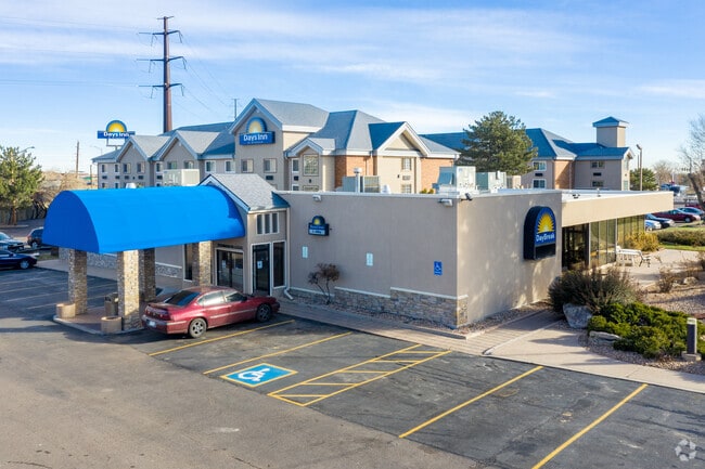


This Property Is For Sale
NEARBY LISTINGS FOR SALE OR LEASE
-
-
View all Lakewood listings for sale on LoopNet.com
Property Detail
15059 W Colfax Ave
Denver-Aurora-Centennial, CO
Days Inn Of Denver #1 Ex Sur #1
40-014-01-001
SECTION 01 TOWNSHIP 04 RANGE 70 QTR SE SUBDIVISIONCD 200000 SUBDIVISIONNAME DAYS INN OF DENVER #1 EX SUR #1 BLOCK LOT 0001 SIZE: 132818 TRACT VALUE: 3.049
Commercialnec
Jefferson
X
Colorado
08059C0281F
1
2023
3.05 AC
2024
Denver West
010100
Denver
5,725 SF
DEMOGRAPHICS near 15059 W Colfax Ave
1 Mile
3 Mile
5 Mile
2024 Total Population
5,387
61,072
155,826
2029 Population
5,360
60,818
154,658
Pop Growth 2024-2029
(0.50%)
(0.42%)
(0.75%)
Average Age
41
41
42
2024 Total Households
2,286
26,667
65,300
HH Growth 2024-2029
(0.44%)
(0.43%)
(0.79%)
Median Household Inc
$98,432
$85,733
$90,298
Avg Household Size
2.20
2.20
2.30
2024 Avg HH Vehicles
2.00
2.00
2.00
Median Home Value
$545,359
$580,401
$618,475
Median Year Built
1977
1976
1975
Nearby Places
Map Layers
Map Styles
 Street
 Aerial
- Restaurants
- Banks
- Shops
- Fitness
- Groceries
PUBLIC TRANSPORTATION
COMMUTER RAIL
Wheat Ridge - Ward Station Track 1 (Union Station to Wheat Ridge Ward Station - Regional Transportation District)
DRIVE
WALK
Distance
Wheat Ridge - Ward Station Track 1 (Union Station to Wheat Ridge Ward Station - Regional Transportation District)
9 min
5.8 mi
Arvada Ridge Station Track 1 (Union Station to Wheat Ridge Ward Station - Regional Transportation District)
DRIVE
WALK
Distance
Arvada Ridge Station Track 1 (Union Station to Wheat Ridge Ward Station - Regional Transportation District)
10 min
6.8 mi
AIRPORT
Denver International
DRIVE
WALK
Distance
Denver International
43 min
34.4 mi
Freight Ports
Tulsa Port Of Catoosa
DRIVE
WALK
Distance
Tulsa Port Of Catoosa
740 min
719.9 mi
Nearby Properties
Address
Land Use
TOTAL SIZE
Lot Size
Zoning
Address
Land Use
TOTAL SIZE
Lot Size
Zoning
943,179 SF
23.96 AC
Address
Land Use
TOTAL SIZE
Lot Size
Zoning
830,160 SF
26.93 AC
Address
Land Use
TOTAL SIZE
Lot Size
Zoning
Address
Land Use
TOTAL SIZE
Lot Size
Zoning
3,195,026 SF
562.97 AC
Address
Land Use
TOTAL SIZE
Lot Size
Zoning
367,452 SF
38.94 AC
Address
Land Use
TOTAL SIZE
Lot Size
Zoning
229,819 SF
29.97 AC
Address
Land Use
TOTAL SIZE
Lot Size
Zoning
1,193,158 SF
68.86 AC
Address
Land Use
TOTAL SIZE
Lot Size
Zoning
420,482 SF
66.03 AC
Address
Land Use
TOTAL SIZE
Lot Size
Zoning
352,259 SF
17.94 AC
Address
Land Use
TOTAL SIZE
Lot Size
Zoning
198,081 SF
Address
Land Use
TOTAL SIZE
Lot Size
Zoning
Address
Land Use
TOTAL SIZE
Lot Size
Zoning
188,554 SF
33.28 AC
Address
Land Use
TOTAL SIZE
Lot Size
Zoning
187,745 SF
16.25 AC
Address
Land Use
TOTAL SIZE
Lot Size
Zoning
282,190 SF
6.42 AC
PD
Address
Land Use
TOTAL SIZE
Lot Size
Zoning
322,105 SF
136.23 AC
Address
Land Use
TOTAL SIZE
Lot Size
Zoning
198,147 SF
2.55 AC
Address
Land Use
TOTAL SIZE
Lot Size
Zoning
239,510 SF
6.63 AC
Address
Land Use
TOTAL SIZE
Lot Size
Zoning
738 SF
3.69 AC
Address
Land Use
TOTAL SIZE
Lot Size
Zoning
118,522 SF
7.07 AC
PD
Address
Land Use
TOTAL SIZE
Lot Size
Zoning
298,767 SF
4.43 AC
Address
Land Use
TOTAL SIZE
Lot Size
Zoning
397,700 SF
14.45 AC
Address
Land Use
TOTAL SIZE
Lot Size
Zoning
365,230 SF
12.51 AC
Address
Land Use
TOTAL SIZE
Lot Size
Zoning
1,115,227 SF
84.74 AC
I2
Address
Land Use
TOTAL SIZE
Lot Size
Zoning
284,413 SF
3.82 AC
Address
Land Use
TOTAL SIZE
Lot Size
Zoning
167,420 SF
5.84 AC
Address
Land Use
TOTAL SIZE
Lot Size
Zoning
214,839 SF
8.17 AC
Address
Land Use
TOTAL SIZE
Lot Size
Zoning
299,678 SF
20.79 AC
PD
Address
Land Use
TOTAL SIZE
Lot Size
Zoning
147,609 SF
9.22 AC
Address
Land Use
TOTAL SIZE
Lot Size
Zoning
55,030 SF
4.94 AC
Address
Land Use
TOTAL SIZE
Lot Size
Zoning
391,227 SF
5.77 AC
The World's #1 Commercial Real Estate Marketplace
Connect with us
© 2026 CoStar Group
The information above has been obtained from sources believed reliable. While we do not doubt its accuracy we have not verified it and make no guarantee, warranty or representation about it. It is your responsibility to independently confirm its accuracy and completeness. Any projections, opinions, assumptions, or estimates used are for example only and do not represent the current or future performance of the property. The value of this transaction to you depends on tax and other factors which should be evaluated by your tax, financial, and legal advisors. You and your advisors should conduct a careful, independent investigation of the property to determine to your satisfaction the suitability of the property for your needs.