Property Record
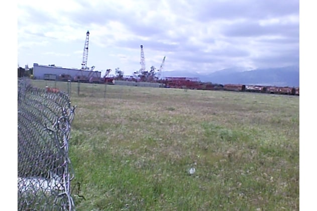
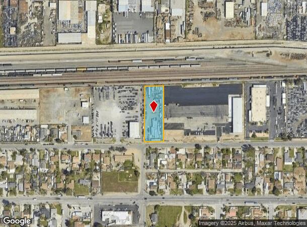
15102 Ceres Ave, Fontana, CA 92335
NEARBY LISTINGS FOR SALE OR LEASE
Property Detail
15102 Ceres Ave
Riverside-San Bernardino-Ontario, CA
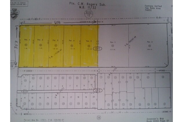
Parcel Map No 17911
0233-011-05
PARCEL MAP 17911 PARCEL 1 BOOK 229 PAGE 96 AND PTN HEMLOCK AVENUE VAC ADJ ON THE WEST
Slaughterhousestockyard
San Bernardino
X
California
06071C8653J
1 AC
2024
Airport Area
2025
Inland Empire (California)
002403
DEMOGRAPHICS near 15102 Ceres Ave
1 Mile
3 Mile
5 Mile
2024 Total Population
15,499
143,229
320,649
2029 Population
15,726
145,457
325,795
Pop Growth 2024-2029
+ 1.46%
+ 1.56%
+ 1.60%
Average Age
35
35
35
2024 Total Households
3,392
37,009
85,582
HH Growth 2024-2029
+ 1.47%
+ 1.57%
+ 1.64%
Median Household Inc
$83,522
$81,502
$90,221
Avg Household Size
4.30
3.80
3.60
2024 Avg HH Vehicles
3.00
2.00
2.00
Median Home Value
$366,967
$462,697
$473,664
Median Year Built
1981
1986
1989
Nearby Places
Map Layers
Map Styles
 Street
 Aerial
- Restaurants
- Banks
- Shops
- Fitness
- Groceries
PUBLIC TRANSPORTATION
COMMUTER RAIL
Fontana (San Bernardino Line - Southern California Regional Rail Authority (Metrolink))
DRIVE
WALK
Distance
Fontana (San Bernardino Line - Southern California Regional Rail Authority (Metrolink))
5 min
2.5 mi
Rancho Cucamonga (San Bernardino Line - Southern California Regional Rail Authority (Metrolink))
DRIVE
WALK
Distance
Rancho Cucamonga (San Bernardino Line - Southern California Regional Rail Authority (Metrolink))
11 min
6.1 mi
AIRPORT
Ontario International
DRIVE
WALK
Distance
Ontario International
15 min
9.7 mi
Freight Ports
Port of Long Beach
DRIVE
WALK
Distance
Port of Long Beach
78 min
62.1 mi
Nearby Properties
Address
Land Use
TOTAL SIZE
Lot Size
Zoning
Address
Land Use
TOTAL SIZE
Lot Size
Zoning
2,027,688 SF
46.50 AC
Address
Land Use
TOTAL SIZE
Lot Size
Zoning
362.37 AC
Address
Land Use
TOTAL SIZE
Lot Size
Zoning
425.43 AC
SDCOM
Address
Land Use
TOTAL SIZE
Lot Size
Zoning
690,967 SF
33.39 AC
Address
Land Use
TOTAL SIZE
Lot Size
Zoning
912 SF
370.60 AC
IR
Address
Land Use
TOTAL SIZE
Lot Size
Zoning
1,286,569 SF
53.96 AC
Address
Land Use
TOTAL SIZE
Lot Size
Zoning
249,658 SF
20.03 AC
Address
Land Use
TOTAL SIZE
Lot Size
Zoning
500,403 SF
24.69 AC
Address
Land Use
TOTAL SIZE
Lot Size
Zoning
319,375 SF
14.66 AC
Address
Land Use
TOTAL SIZE
Lot Size
Zoning
55.52 AC
Address
Land Use
TOTAL SIZE
Lot Size
Zoning
300,205 SF
12.63 AC
Address
Land Use
TOTAL SIZE
Lot Size
Zoning
76.50 AC
Address
Land Use
TOTAL SIZE
Lot Size
Zoning
849,900 SF
39.25 AC
KCSP
Address
Land Use
TOTAL SIZE
Lot Size
Zoning
291,742 SF
12.10 AC
Address
Land Use
TOTAL SIZE
Lot Size
Zoning
194,595 SF
8.61 AC
Address
Land Use
TOTAL SIZE
Lot Size
Zoning
214,495 SF
9.89 AC
SDCOM
Address
Land Use
TOTAL SIZE
Lot Size
Zoning
1,034,356 SF
47.48 AC
Address
Land Use
TOTAL SIZE
Lot Size
Zoning
278,453 SF
4.73 AC
Address
Land Use
TOTAL SIZE
Lot Size
Zoning
236,129 SF
10.45 AC
Address
Land Use
TOTAL SIZE
Lot Size
Zoning
118,984 SF
16.07 AC
IR
Address
Land Use
TOTAL SIZE
Lot Size
Zoning
330,048 SF
13.37 AC
Address
Land Use
TOTAL SIZE
Lot Size
Zoning
42.45 AC
Address
Land Use
TOTAL SIZE
Lot Size
Zoning
263,532 SF
13.14 AC
Address
Land Use
TOTAL SIZE
Lot Size
Zoning
39.55 AC
Address
Land Use
TOTAL SIZE
Lot Size
Zoning
700,709 SF
34.99 AC
IR
Address
Land Use
TOTAL SIZE
Lot Size
Zoning
1,380,498 SF
74.36 AC
Address
Land Use
TOTAL SIZE
Lot Size
Zoning
234,724 SF
14.02 AC
FW
Address
Land Use
TOTAL SIZE
Lot Size
Zoning
528,253 SF
22.99 AC
Address
Land Use
TOTAL SIZE
Lot Size
Zoning
254,812 SF
6.99 AC
Address
Land Use
TOTAL SIZE
Lot Size
Zoning
600,080 SF
32.43 AC
KCSP
The World's #1 Commercial Real Estate Marketplace
Connect with us
© 2026 CoStar Group
The information above has been obtained from sources believed reliable. While we do not doubt its accuracy we have not verified it and make no guarantee, warranty or representation about it. It is your responsibility to independently confirm its accuracy and completeness. Any projections, opinions, assumptions, or estimates used are for example only and do not represent the current or future performance of the property. The value of this transaction to you depends on tax and other factors which should be evaluated by your tax, financial, and legal advisors. You and your advisors should conduct a careful, independent investigation of the property to determine to your satisfaction the suitability of the property for your needs.