Property Record
1507 County Rd 731, Labelle, FL 33935
NEARBY LISTINGS FOR SALE OR LEASE
-
-
View all Labelle listings for sale on LoopNet.com
Property Detail
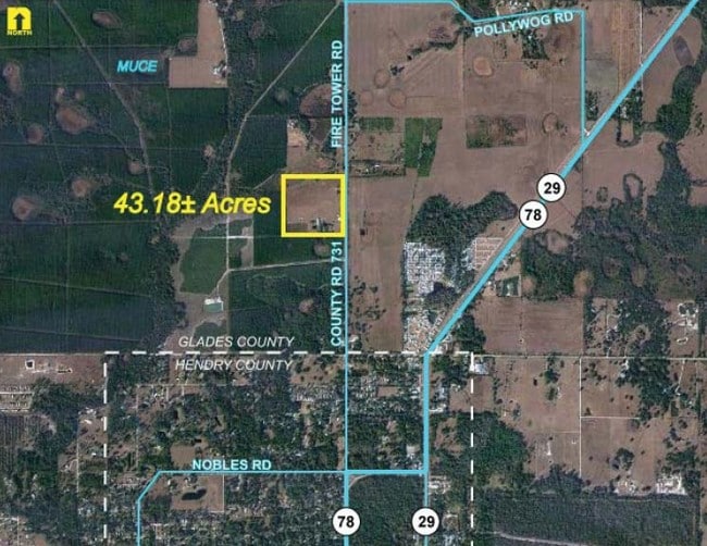
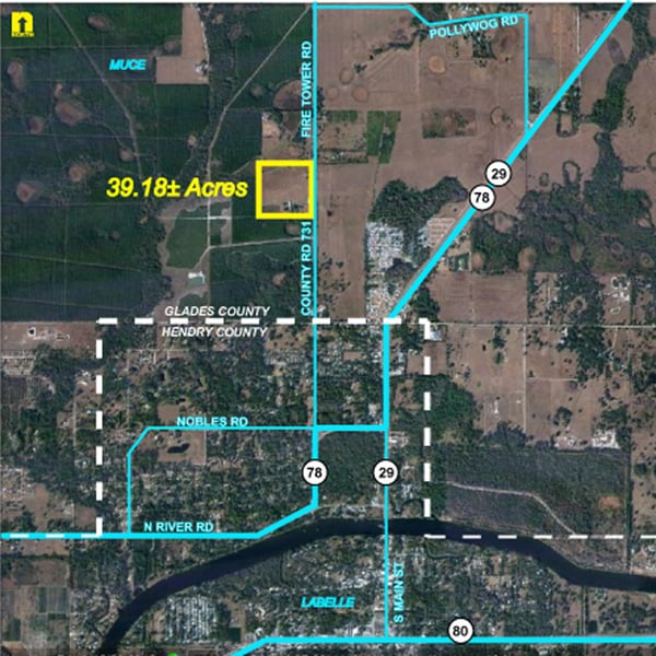
1507 County Rd 731
Pasture
SE 1/4 OF NW 1/4 LESS CR 731 RWY TOTAL ACRES 39.00 M/L
AE
Glades
12051C0040D
Florida
2025
39 AC
2025
Florida Central South Area
000404
Other Market Areas
2,547 SF
A29-42-29-A00-0040-0000
DEMOGRAPHICS near 1507 County Rd 731
1 Mile
3 Mile
5 Mile
2024 Total Population
1,785
9,424
18,656
2029 Population
1,888
10,124
20,355
Pop Growth 2024-2029
+ 5.77%
+ 7.43%
+ 9.11%
Average Age
39
39
38
2024 Total Households
574
3,064
5,876
HH Growth 2024-2029
+ 6.10%
+ 7.83%
+ 9.53%
Median Household Inc
$50,164
$41,770
$38,435
Avg Household Size
2.90
2.90
3.00
2024 Avg HH Vehicles
2.00
2.00
2.00
Median Home Value
$83,143
$145,386
$146,348
Median Year Built
1987
1984
1987
Nearby Places
Map Layers
Map Styles
 Street
 Aerial
- Restaurants
- Banks
- Shops
- Fitness
- Groceries
PUBLIC TRANSPORTATION
AIRPORT
Southwest Florida International
DRIVE
WALK
Distance
Southwest Florida International
57 min
35.7 mi
Freight Ports
Port of Palm Beach
DRIVE
WALK
Distance
Port of Palm Beach
143 min
100.8 mi
SALE & LEASE HISTORY
LISTING DATE
SALE/LEASE

Sep 24, 2016
For Sale
Nearby Properties
Address
Land Use
TOTAL SIZE
Lot Size
Zoning
Address
Land Use
TOTAL SIZE
Lot Size
Zoning
92,534 SF
4.50 AC
LB-B-2
Address
Land Use
TOTAL SIZE
Lot Size
Zoning
73,721 SF
156.92 AC
Address
Land Use
TOTAL SIZE
Lot Size
Zoning
62,150 SF
1.56 AC
LB-PUBLIC
Address
Land Use
TOTAL SIZE
Lot Size
Zoning
38,208 SF
2.12 AC
LB-PUBLIC
Address
Land Use
TOTAL SIZE
Lot Size
Zoning
68,843 SF
6.10 AC
LB-B-2
Address
Land Use
TOTAL SIZE
Lot Size
Zoning
70,970 SF
3.14 AC
PUD
Address
Land Use
TOTAL SIZE
Lot Size
Zoning
11,174 SF
39.84 AC
Address
Land Use
TOTAL SIZE
Lot Size
Zoning
82,678 SF
9.57 AC
LB-PUBLIC
Address
Land Use
TOTAL SIZE
Lot Size
Zoning
62,250 SF
14 AC
C-2
Address
Land Use
TOTAL SIZE
Lot Size
Zoning
26,947 SF
1.79 AC
LB-B-2
Address
Land Use
TOTAL SIZE
Lot Size
Zoning
31,615 SF
3.40 AC
LB-B-1
Address
Land Use
TOTAL SIZE
Lot Size
Zoning
249.50 AC
Address
Land Use
TOTAL SIZE
Lot Size
Zoning
18,643 SF
4.71 AC
LB-B-1
Address
Land Use
TOTAL SIZE
Lot Size
Zoning
11,099 SF
2.47 AC
LB-PUD
Address
Land Use
TOTAL SIZE
Lot Size
Zoning
13,333 SF
0.58 AC
LB-R-1A
Address
Land Use
TOTAL SIZE
Lot Size
Zoning
19,486 SF
1.67 AC
LB-R-1AA
Address
Land Use
TOTAL SIZE
Lot Size
Zoning
56.87 AC
LB-B-3
Address
Land Use
TOTAL SIZE
Lot Size
Zoning
16,288 SF
4.68 AC
LB-B-2
Address
Land Use
TOTAL SIZE
Lot Size
Zoning
13,768 SF
8.56 AC
LB-R-1AA
Address
Land Use
TOTAL SIZE
Lot Size
Zoning
15,861 SF
1.03 AC
LB-B-2
Address
Land Use
TOTAL SIZE
Lot Size
Zoning
480.28 AC
A-2
Address
Land Use
TOTAL SIZE
Lot Size
Zoning
37,568 SF
25 AC
RG
Address
Land Use
TOTAL SIZE
Lot Size
Zoning
49,075 SF
18.62 AC
LB-PUBLIC
Address
Land Use
TOTAL SIZE
Lot Size
Zoning
40.14 AC
RG2
Address
Land Use
TOTAL SIZE
Lot Size
Zoning
12,610 SF
1.10 AC
LB-B-2
Address
Land Use
TOTAL SIZE
Lot Size
Zoning
12,393 SF
0.70 AC
LB-R-3
Address
Land Use
TOTAL SIZE
Lot Size
Zoning
11,288 SF
1.59 AC
LB-B-1
Address
Land Use
TOTAL SIZE
Lot Size
Zoning
240 SF
8.16 AC
Address
Land Use
TOTAL SIZE
Lot Size
Zoning
4,960 SF
1.91 AC
LB-B-2
Address
Land Use
TOTAL SIZE
Lot Size
Zoning
19.28 AC
The World's #1 Commercial Real Estate Marketplace
Connect with us
© 2025 CoStar Group
The information above has been obtained from sources believed reliable. While we do not doubt its accuracy we have not verified it and make no guarantee, warranty or representation about it. It is your responsibility to independently confirm its accuracy and completeness. Any projections, opinions, assumptions, or estimates used are for example only and do not represent the current or future performance of the property. The value of this transaction to you depends on tax and other factors which should be evaluated by your tax, financial, and legal advisors. You and your advisors should conduct a careful, independent investigation of the property to determine to your satisfaction the suitability of the property for your needs.