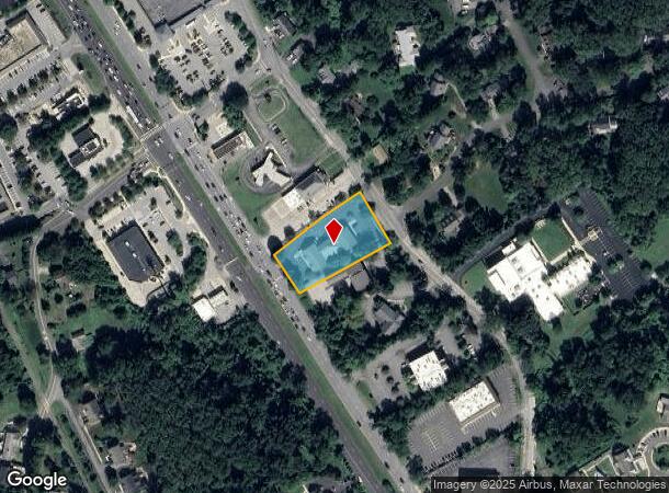
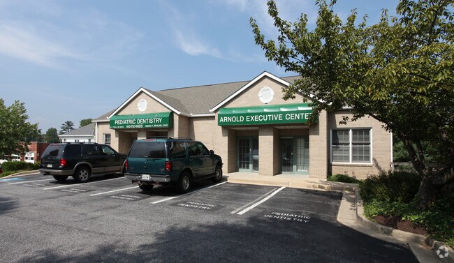
Property Record
1507 Ritchie Hwy, Arnold, MD 21012

NEARBY LISTINGS FOR SALE OR LEASE
Property Detail
1507 Ritchie Hwy
Baltimore-Columbia-Towson, MD
Arnold
03-000-90050742
LT 2 OR .9437 ACRE ARNOLD
Medicalbuilding
Anne Arundel
X
Maryland
24003C0169F
2
2024
0.94 AC
2025
Route 2 Corridor South
731103
Baltimore
14,874 SF
DEMOGRAPHICS near 1507 Ritchie Hwy
1 Mile
3 Mile
5 Mile
2024 Total Population
3,909
43,753
116,334
2029 Population
4,010
44,779
119,381
Pop Growth 2024-2029
+ 2.58%
+ 2.34%
+ 2.62%
Average Age
42
41
41
2024 Total Households
1,306
16,472
45,170
HH Growth 2024-2029
+ 2.60%
+ 2.39%
+ 2.71%
Median Household Inc
$158,597
$139,722
$127,242
Avg Household Size
2.90
2.60
2.50
2024 Avg HH Vehicles
2.00
2.00
2.00
Median Home Value
$644,126
$531,534
$560,434
Median Year Built
1974
1981
1978
Nearby Places
Map Layers
Map Styles
 Street
 Aerial
- Restaurants
- Banks
- Shops
- Fitness
- Groceries
PUBLIC TRANSPORTATION
AIRPORT
Baltimore/Washington International Thurgood Marshall
DRIVE
WALK
Distance
Baltimore/Washington International Thurgood Marshall
29 min
18.3 mi
Freight Ports
Port of Baltimore
DRIVE
WALK
Distance
Port of Baltimore
36 min
20.1 mi
SALE & LEASE HISTORY
LISTING DATE
SALE/LEASE

Feb 16, 2018
For Lease
Nearby Properties
Address
Land Use
TOTAL SIZE
Lot Size
Zoning
Address
Land Use
TOTAL SIZE
Lot Size
Zoning
301,324 SF
169 AC
R1
Address
Land Use
TOTAL SIZE
Lot Size
Zoning
434,112 SF
822.11 AC
R1
Address
Land Use
TOTAL SIZE
Lot Size
Zoning
406,976 SF
18.98 AC
R2
Address
Land Use
TOTAL SIZE
Lot Size
Zoning
58.99 AC
R2
Address
Land Use
TOTAL SIZE
Lot Size
Zoning
346,335 SF
16.42 AC
R22
Address
Land Use
TOTAL SIZE
Lot Size
Zoning
440,628 SF
38.41 AC
R2
Address
Land Use
TOTAL SIZE
Lot Size
Zoning
117,577 SF
6.92 AC
R2
Address
Land Use
TOTAL SIZE
Lot Size
Zoning
318,622 SF
62.01 AC
R5
Address
Land Use
TOTAL SIZE
Lot Size
Zoning
125,266 SF
65.33 AC
R1
Address
Land Use
TOTAL SIZE
Lot Size
Zoning
100,800 SF
6.79 AC
C2
Address
Land Use
TOTAL SIZE
Lot Size
Zoning
75,073 SF
5.53 AC
P
Address
Land Use
TOTAL SIZE
Lot Size
Zoning
100,236 SF
12.99 AC
R5
Address
Land Use
TOTAL SIZE
Lot Size
Zoning
56,415 SF
5.02 AC
R1
Address
Land Use
TOTAL SIZE
Lot Size
Zoning
5.62 AC
R15
Address
Land Use
TOTAL SIZE
Lot Size
Zoning
7.56 AC
R15
Address
Land Use
TOTAL SIZE
Lot Size
Zoning
3,412 SF
16.95 AC
Address
Land Use
TOTAL SIZE
Lot Size
Zoning
88,832 SF
8.09 AC
C3
Address
Land Use
TOTAL SIZE
Lot Size
Zoning
107,910 SF
7.25 AC
C2
Address
Land Use
TOTAL SIZE
Lot Size
Zoning
44,680 SF
3.54 AC
C3
Address
Land Use
TOTAL SIZE
Lot Size
Zoning
31,836 SF
13.51 AC
R2
Address
Land Use
TOTAL SIZE
Lot Size
Zoning
60,971 SF
5.04 AC
C3
Address
Land Use
TOTAL SIZE
Lot Size
Zoning
72,936 SF
5.46 AC
C2
Address
Land Use
TOTAL SIZE
Lot Size
Zoning
9.90 AC
R15
Address
Land Use
TOTAL SIZE
Lot Size
Zoning
47,306 SF
2.25 AC
R22
Address
Land Use
TOTAL SIZE
Lot Size
Zoning
45,200 SF
3.28 AC
C4
Address
Land Use
TOTAL SIZE
Lot Size
Zoning
55,944 SF
14.50 AC
R5
Address
Land Use
TOTAL SIZE
Lot Size
Zoning
74,540 SF
53.76 AC
R5
Address
Land Use
TOTAL SIZE
Lot Size
Zoning
30,153 SF
7.05 AC
C4
Address
Land Use
TOTAL SIZE
Lot Size
Zoning
56,370 SF
6.53 AC
C4
Address
Land Use
TOTAL SIZE
Lot Size
Zoning
53,843 SF
7.24 AC
C3
The World's #1 Commercial Real Estate Marketplace
Connect with us
© 2025 CoStar Group
The information above has been obtained from sources believed reliable. While we do not doubt its accuracy we have not verified it and make no guarantee, warranty or representation about it. It is your responsibility to independently confirm its accuracy and completeness. Any projections, opinions, assumptions, or estimates used are for example only and do not represent the current or future performance of the property. The value of this transaction to you depends on tax and other factors which should be evaluated by your tax, financial, and legal advisors. You and your advisors should conduct a careful, independent investigation of the property to determine to your satisfaction the suitability of the property for your needs.