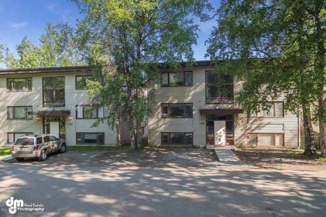
Property Record
1507 W 45Th Ave, Anchorage, AK 99503

Save to a Folder
{{folder.Name}}
{{folder.ListingIds.length}} Properties
{{folder.ListingIds.length}} Property
Create a New Folder
Property Detail
1507 W 45Th Ave
01022124000
BIRCHWOOD PARK BLK A LT 12
Apartment
Anchorage
R2A
Alaska
B and X Area of moderate flood hazard, usually the area between the limits of the 100-year and 500-year floods.
12
2025
0.35 AC
2025
Spenard
002400
Anchorage
6,000 SF
Anchorage, AK
NEARBY LISTINGS FOR SALE OR LEASE
DEMOGRAPHICS near 1507 W 45Th Ave
1 mile
3 mile
5 mile
2025 Total Population
12,634
92,682
172,731
2030 Population
12,680
92,915
173,124
Pop Growth 2025-2030
+ 0.36%
+ 0.25%
+ 0.23%
Average Age
39
39
38
2025 Total Households
5,455
38,387
67,699
HH Growth 2025-2030
+ 0.42%
+ 0.32%
+ 0.26%
Median Household Inc
$82,950
$90,374
$91,353
Avg Household Size
2.20
2.30
2.40
2025 Avg HH Vehicles
2.00
2.00
2.00
Median Home Value
$310,952
$361,539
$366,420
Median Year Built
1971
1977
1980
Nearby Places
Map Layers
Map Styles
 Street
 Aerial
Layers
 Traffic
 Biking
Places
Listings with unknown addresses are not visible on the map
- Restaurants
- Banks
- Shops
- Fitness
- Groceries
PUBLIC TRANSPORTATION
AIRPORT
Ted Stevens Anchorage International
Drive
Walk
Distance
Ted Stevens Anchorage International
7 min
3.2 mi
Merrill Field
Drive
Walk
Distance
Merrill Field
11 min
5.3 mi
Nearby Properties
Address
Land Use
TOTAL SIZE
Lot Size
Zoning
Address
Land Use
TOTAL SIZE
Lot Size
Zoning
181,492 SF
1.70 AC
B2B
Address
Land Use
TOTAL SIZE
Lot Size
Zoning
199,186 SF
2.11 AC
B2B
Address
Land Use
TOTAL SIZE
Lot Size
Zoning
127,232 SF
4.55 AC
B2B
Address
Land Use
TOTAL SIZE
Lot Size
Zoning
91,034 SF
63.70 AC
TR
Address
Land Use
TOTAL SIZE
Lot Size
Zoning
171,692 SF
23.09 AC
I1
Address
Land Use
TOTAL SIZE
Lot Size
Zoning
117,702 SF
9.85 AC
B3SL
Address
Land Use
TOTAL SIZE
Lot Size
Zoning
134,626 SF
16.91 AC
PLI
Address
Land Use
TOTAL SIZE
Lot Size
Zoning
87,865 SF
0.48 AC
B2B
Address
Land Use
TOTAL SIZE
Lot Size
Zoning
381,477 SF
33.30 AC
B3
Address
Land Use
TOTAL SIZE
Lot Size
Zoning
195,079 SF
44.79 AC
PLI
Address
Land Use
TOTAL SIZE
Lot Size
Zoning
267,442 SF
61.04 AC
PLI
Address
Land Use
TOTAL SIZE
Lot Size
Zoning
86,316 SF
2 AC
B2B
Address
Land Use
TOTAL SIZE
Lot Size
Zoning
61,127 SF
3.04 AC
B3
Address
Land Use
TOTAL SIZE
Lot Size
Zoning
121,359 SF
4.35 AC
B3SL
Address
Land Use
TOTAL SIZE
Lot Size
Zoning
120,000 SF
9.09 AC
PLI
Address
Land Use
TOTAL SIZE
Lot Size
Zoning
47,774 SF
1.61 AC
B2B
Address
Land Use
TOTAL SIZE
Lot Size
Zoning
36,837 SF
0.80 AC
B2B
Address
Land Use
TOTAL SIZE
Lot Size
Zoning
124,058 SF
18.15 AC
B3
Address
Land Use
TOTAL SIZE
Lot Size
Zoning
56,747 SF
6.89 AC
B3SL
Address
Land Use
TOTAL SIZE
Lot Size
Zoning
33,360 SF
0.96 AC
B2B
Address
Land Use
TOTAL SIZE
Lot Size
Zoning
66,354 SF
44.23 AC
I2
Address
Land Use
TOTAL SIZE
Lot Size
Zoning
7,711 SF
1.93 AC
B2A
Address
Land Use
TOTAL SIZE
Lot Size
Zoning
242,189 SF
21.83 AC
I2
Address
Land Use
TOTAL SIZE
Lot Size
Zoning
168,640 SF
3.38 AC
I2
Address
Land Use
TOTAL SIZE
Lot Size
Zoning
84,157 SF
3.41 AC
B3
Address
Land Use
TOTAL SIZE
Lot Size
Zoning
170,000 SF
2.40 AC
B2A
Address
Land Use
TOTAL SIZE
Lot Size
Zoning
341,267 SF
5.51 AC
TR
Address
Land Use
TOTAL SIZE
Lot Size
Zoning
112,874 SF
6.61 AC
ROSL
Address
Land Use
TOTAL SIZE
Lot Size
Zoning
217,754 SF
14.42 AC
I1
Address
Land Use
TOTAL SIZE
Lot Size
Zoning
171,800 SF
1.67 AC
B3
The World's #1 Commercial Real Estate Marketplace
Connect with us
© 2026 CoStar Group
The information above has been obtained from sources believed reliable. While we do not doubt its accuracy we have not verified it and make no guarantee, warranty or representation about it. It is your responsibility to independently confirm its accuracy and completeness. Any projections, opinions, assumptions, or estimates used are for example only and do not represent the current or future performance of the property. The value of this transaction to you depends on tax and other factors which should be evaluated by your tax, financial, and legal advisors. You and your advisors should conduct a careful, independent investigation of the property to determine to your satisfaction the suitability of the property for your needs.