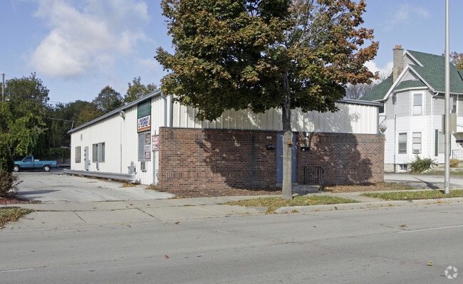
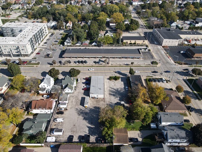
Property Record
1519 S 84Th St, Milwaukee, WI 53214
NEARBY LISTINGS FOR SALE OR LEASE
Property Detail
1519 S 84Th St
Milwaukee-Waukesha-West Allis, WI
Assessor's Plat 257
451-0665-002
HOMESTEAD CO PLAT LOT 1 BLK 1
Commercialnec
Milwaukee
X
Wisconsin
55133C0250G
1
2024
0.50 AC
2024
West Allis
101100
Milwaukee/Madison
DEMOGRAPHICS near 1519 S 84Th St
1 Mile
3 Mile
5 Mile
2024 Total Population
22,134
131,450
399,733
2029 Population
21,692
128,376
393,298
Pop Growth 2024-2029
(2.00%)
(2.34%)
(1.61%)
Average Age
40
40
38
2024 Total Households
10,037
59,074
164,514
HH Growth 2024-2029
(2.04%)
(2.37%)
(1.61%)
Median Household Inc
$60,569
$65,546
$58,286
Avg Household Size
2.10
2.20
2.30
2024 Avg HH Vehicles
2.00
2.00
2.00
Median Home Value
$161,957
$186,658
$203,684
Median Year Built
1950
1955
1953
Nearby Places
Map Layers
Map Styles
 Street
 Aerial
- Restaurants
- Banks
- Shops
- Fitness
- Groceries
PUBLIC TRANSPORTATION
COMMUTER RAIL
DRIVE
WALK
Distance
11 min
6.2 mi
AIRPORT
General Mitchell International
DRIVE
WALK
Distance
General Mitchell International
23 min
12.1 mi
Freight Ports
Port Milwaukee
DRIVE
WALK
Distance
Port Milwaukee
16 min
8.6 mi
SALE & LEASE HISTORY
LISTING DATE
SALE/LEASE

Nov 11, 2021
For Sale
Nearby Properties
Address
Land Use
TOTAL SIZE
Lot Size
Zoning
Address
Land Use
TOTAL SIZE
Lot Size
Zoning
8.63 AC
C2
Address
Land Use
TOTAL SIZE
Lot Size
Zoning
36.11 AC
Address
Land Use
TOTAL SIZE
Lot Size
Zoning
Address
Land Use
TOTAL SIZE
Lot Size
Zoning
122.53 AC
TL
Address
Land Use
TOTAL SIZE
Lot Size
Zoning
23.16 AC
Address
Land Use
TOTAL SIZE
Lot Size
Zoning
20.36 AC
Address
Land Use
TOTAL SIZE
Lot Size
Zoning
13.48 AC
Address
Land Use
TOTAL SIZE
Lot Size
Zoning
5.12 AC
Address
Land Use
TOTAL SIZE
Lot Size
Zoning
Address
Land Use
TOTAL SIZE
Lot Size
Zoning
10.22 AC
SP-RP
Address
Land Use
TOTAL SIZE
Lot Size
Zoning
68.35 AC
TL
Address
Land Use
TOTAL SIZE
Lot Size
Zoning
Address
Land Use
TOTAL SIZE
Lot Size
Zoning
8,881 SF
7.52 AC
Address
Land Use
TOTAL SIZE
Lot Size
Zoning
13.39 AC
Address
Land Use
TOTAL SIZE
Lot Size
Zoning
9.33 AC
PUD
Address
Land Use
TOTAL SIZE
Lot Size
Zoning
47.96 AC
TL
Address
Land Use
TOTAL SIZE
Lot Size
Zoning
3.74 AC
PUD
Address
Land Use
TOTAL SIZE
Lot Size
Zoning
10.92 AC
Address
Land Use
TOTAL SIZE
Lot Size
Zoning
16.84 AC
Address
Land Use
TOTAL SIZE
Lot Size
Zoning
2.13 AC
SP-MED
Address
Land Use
TOTAL SIZE
Lot Size
Zoning
Address
Land Use
TOTAL SIZE
Lot Size
Zoning
39.81 AC
Address
Land Use
TOTAL SIZE
Lot Size
Zoning
29,664 SF
1.83 AC
C2
Address
Land Use
TOTAL SIZE
Lot Size
Zoning
8.78 AC
Address
Land Use
TOTAL SIZE
Lot Size
Zoning
0.36 AC
Address
Land Use
TOTAL SIZE
Lot Size
Zoning
Address
Land Use
TOTAL SIZE
Lot Size
Zoning
20.61 AC
TL
Address
Land Use
TOTAL SIZE
Lot Size
Zoning
7.55 AC
SP-RP
Address
Land Use
TOTAL SIZE
Lot Size
Zoning
Address
Land Use
TOTAL SIZE
Lot Size
Zoning
12.47 AC
The World's #1 Commercial Real Estate Marketplace
Connect with us
© 2025 CoStar Group
The information above has been obtained from sources believed reliable. While we do not doubt its accuracy we have not verified it and make no guarantee, warranty or representation about it. It is your responsibility to independently confirm its accuracy and completeness. Any projections, opinions, assumptions, or estimates used are for example only and do not represent the current or future performance of the property. The value of this transaction to you depends on tax and other factors which should be evaluated by your tax, financial, and legal advisors. You and your advisors should conduct a careful, independent investigation of the property to determine to your satisfaction the suitability of the property for your needs.