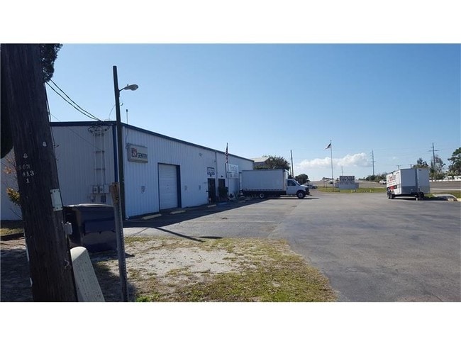
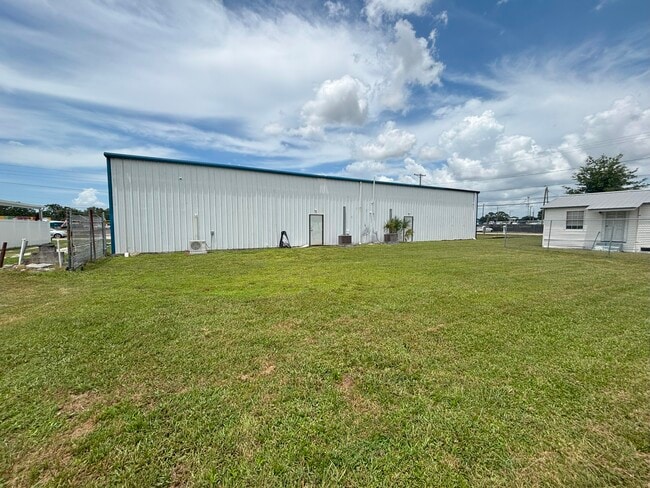
Property Record
1509 7Th St Sw, Ruskin, FL 33570

NEARBY LISTINGS FOR SALE OR LEASE
Property Detail
1509 7Th St Sw
Tampa-St. Petersburg-Clearwater, FL
Saffold Park Subdivision Unit No 1
U-18-32-19-20P-A00000-00015.0
SAFFOLD PARK SUBDIVISION UNIT NO 1 LOT 16 AND 17 AND 18 BLOCK A
Sfr
Hillsborough
X
Florida
12057C0654J
16
2024
0.23 AC
2025
Southeast Hillsborough
014109
Tampa/St Petersburg
1,294 SF
DEMOGRAPHICS near 1509 7Th St Sw
1 Mile
3 Mile
5 Mile
2024 Total Population
6,166
39,189
67,523
2029 Population
6,939
44,041
75,851
Pop Growth 2024-2029
+ 12.54%
+ 12.38%
+ 12.33%
Average Age
38
39
46
2024 Total Households
2,149
13,579
26,719
HH Growth 2024-2029
+ 12.52%
+ 12.45%
+ 12.57%
Median Household Inc
$59,968
$72,321
$69,623
Avg Household Size
2.80
2.80
2.40
2024 Avg HH Vehicles
2.00
2.00
2.00
Median Home Value
$216,984
$246,891
$250,137
Median Year Built
1993
2006
2003
Nearby Places
Map Layers
Map Styles
 Street
 Aerial
- Restaurants
- Banks
- Shops
- Fitness
- Groceries
PUBLIC TRANSPORTATION
AIRPORT
Sarasota/Bradenton International
DRIVE
WALK
Distance
Sarasota/Bradenton International
40 min
26.2 mi
Tampa International
DRIVE
WALK
Distance
Tampa International
48 min
31.3 mi
St Pete-Clearwater International
DRIVE
WALK
Distance
St Pete-Clearwater International
58 min
42.7 mi
Freight Ports
Port Manatee
DRIVE
WALK
Distance
Port Manatee
15 min
9.3 mi
SALE & LEASE HISTORY
LISTING DATE
SALE/LEASE

Mar 07, 2017
For Sale
Aug 26, 2025
For Sale
Nearby Properties
Address
Land Use
TOTAL SIZE
Lot Size
Zoning
Address
Land Use
TOTAL SIZE
Lot Size
Zoning
351,758 SF
63.45 AC
PD
Address
Land Use
TOTAL SIZE
Lot Size
Zoning
190,908 SF
49.11 AC
PD
Address
Land Use
TOTAL SIZE
Lot Size
Zoning
132,036 SF
3.30 AC
PD
Address
Land Use
TOTAL SIZE
Lot Size
Zoning
106,623 SF
225.30 AC
AR
Address
Land Use
TOTAL SIZE
Lot Size
Zoning
77,315 SF
9.71 AC
CG
Address
Land Use
TOTAL SIZE
Lot Size
Zoning
478.28 AC
PD
Address
Land Use
TOTAL SIZE
Lot Size
Zoning
51,900 SF
47.60 AC
PD
Address
Land Use
TOTAL SIZE
Lot Size
Zoning
61,680 SF
20.16 AC
PD
Address
Land Use
TOTAL SIZE
Lot Size
Zoning
89,847 SF
8.56 AC
PD
Address
Land Use
TOTAL SIZE
Lot Size
Zoning
41,031 SF
12.16 AC
CN
Address
Land Use
TOTAL SIZE
Lot Size
Zoning
119,624 SF
13.03 AC
M
Address
Land Use
TOTAL SIZE
Lot Size
Zoning
542.23 AC
AR
Address
Land Use
TOTAL SIZE
Lot Size
Zoning
97,398 SF
12.45 AC
RDC-12
Address
Land Use
TOTAL SIZE
Lot Size
Zoning
139.83 AC
PD
Address
Land Use
TOTAL SIZE
Lot Size
Zoning
6,768 SF
47.53 AC
PD
Address
Land Use
TOTAL SIZE
Lot Size
Zoning
129,728 SF
23.85 AC
PD
Address
Land Use
TOTAL SIZE
Lot Size
Zoning
58,695 SF
19.42 AC
PD
Address
Land Use
TOTAL SIZE
Lot Size
Zoning
861 SF
3.74 AC
PD
Address
Land Use
TOTAL SIZE
Lot Size
Zoning
118.69 AC
AR
Address
Land Use
TOTAL SIZE
Lot Size
Zoning
41,310 SF
8.70 AC
PD
Address
Land Use
TOTAL SIZE
Lot Size
Zoning
7,886 SF
344.76 AC
AR
Address
Land Use
TOTAL SIZE
Lot Size
Zoning
25,095 SF
24.54 AC
PD
Address
Land Use
TOTAL SIZE
Lot Size
Zoning
152,891 SF
21.96 AC
PD
Address
Land Use
TOTAL SIZE
Lot Size
Zoning
5,512 SF
44.14 AC
AR
Address
Land Use
TOTAL SIZE
Lot Size
Zoning
21,979 SF
4.70 AC
PD
Address
Land Use
TOTAL SIZE
Lot Size
Zoning
53,071 SF
6.71 AC
RSC-6
Address
Land Use
TOTAL SIZE
Lot Size
Zoning
34,129 SF
15.85 AC
AR
Address
Land Use
TOTAL SIZE
Lot Size
Zoning
42,729 SF
8.70 AC
PD
Address
Land Use
TOTAL SIZE
Lot Size
Zoning
5,985 SF
53.98 AC
AR
Address
Land Use
TOTAL SIZE
Lot Size
Zoning
5,263 SF
10.53 AC
PD
The World's #1 Commercial Real Estate Marketplace
Connect with us
© 2026 CoStar Group
The information above has been obtained from sources believed reliable. While we do not doubt its accuracy we have not verified it and make no guarantee, warranty or representation about it. It is your responsibility to independently confirm its accuracy and completeness. Any projections, opinions, assumptions, or estimates used are for example only and do not represent the current or future performance of the property. The value of this transaction to you depends on tax and other factors which should be evaluated by your tax, financial, and legal advisors. You and your advisors should conduct a careful, independent investigation of the property to determine to your satisfaction the suitability of the property for your needs.