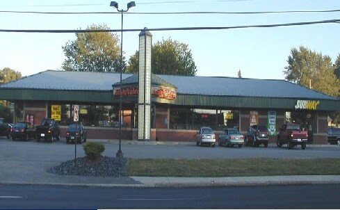
Property Record
1501 E 1509 East 38 St, Erie, PA 16510


Current Lease Availabilities
NEARBY LISTINGS FOR SALE OR LEASE
Property Detail
1501 E 1509 East 38 St
Erie, PA
Lakeview Div
18-052-022.0-110.00
1501-1509 E 38 ST 264 X 150
Storebuilding
Erie
X
Pennsylvania
42049C0206D
11000
2025
0.91 AC
2025
Greater Erie
011508
Erie
8,520 SF
DEMOGRAPHICS near 1501 E 1509 East 38 St
1 Mile
3 Mile
5 Mile
2024 Total Population
12,329
82,811
138,201
2029 Population
12,110
81,872
136,701
Pop Growth 2024-2029
(1.78%)
(1.13%)
(1.09%)
Average Age
41
39
40
2024 Total Households
4,986
32,515
56,537
HH Growth 2024-2029
(1.97%)
(1.25%)
(1.19%)
Median Household Inc
$53,214
$43,029
$47,736
Avg Household Size
2.30
2.30
2.20
2024 Avg HH Vehicles
2.00
1.00
1.00
Median Home Value
$92,727
$101,660
$123,081
Median Year Built
1965
1954
1956
Nearby Places
Map Layers
Map Styles
 Street
 Aerial
- Restaurants
- Banks
- Shops
- Fitness
- Groceries
PUBLIC TRANSPORTATION
COMMUTER RAIL
DRIVE
WALK
Distance
8 min
3.3 mi
AIRPORT
Erie International/Tom Ridge Field
DRIVE
WALK
Distance
Erie International/Tom Ridge Field
20 min
9.0 mi
Nearby Properties
Address
Land Use
TOTAL SIZE
Lot Size
Zoning
Address
Land Use
TOTAL SIZE
Lot Size
Zoning
31,764 SF
46.83 AC
R3
Address
Land Use
TOTAL SIZE
Lot Size
Zoning
227,630 SF
343.90 AC
I1
Address
Land Use
TOTAL SIZE
Lot Size
Zoning
2.73 AC
C3
Address
Land Use
TOTAL SIZE
Lot Size
Zoning
630,344 SF
7.57 AC
RLB
Address
Land Use
TOTAL SIZE
Lot Size
Zoning
12.27 AC
WM
Address
Land Use
TOTAL SIZE
Lot Size
Zoning
5 AC
RLB
Address
Land Use
TOTAL SIZE
Lot Size
Zoning
189,344 SF
2.14 AC
C3
Address
Land Use
TOTAL SIZE
Lot Size
Zoning
800 SF
10.05 AC
R2
Address
Land Use
TOTAL SIZE
Lot Size
Zoning
68,626 SF
86.88 AC
B1
Address
Land Use
TOTAL SIZE
Lot Size
Zoning
375,929 SF
5.02 AC
C3
Address
Land Use
TOTAL SIZE
Lot Size
Zoning
1.56 AC
C3
Address
Land Use
TOTAL SIZE
Lot Size
Zoning
170,870 SF
4.51 AC
RLB
Address
Land Use
TOTAL SIZE
Lot Size
Zoning
92,635 SF
8.45 AC
B1
Address
Land Use
TOTAL SIZE
Lot Size
Zoning
8.60 AC
R2
Address
Land Use
TOTAL SIZE
Lot Size
Zoning
23,092 SF
31.24 AC
DR
Address
Land Use
TOTAL SIZE
Lot Size
Zoning
23.31 AC
C1
Address
Land Use
TOTAL SIZE
Lot Size
Zoning
163,596 SF
14.31 AC
C2
Address
Land Use
TOTAL SIZE
Lot Size
Zoning
0.66 AC
C3
Address
Land Use
TOTAL SIZE
Lot Size
Zoning
178,236 SF
26.15 AC
RLB
Address
Land Use
TOTAL SIZE
Lot Size
Zoning
18.55 AC
M1
Address
Land Use
TOTAL SIZE
Lot Size
Zoning
88,232 SF
1 AC
RLB
Address
Land Use
TOTAL SIZE
Lot Size
Zoning
70,092 SF
10.78 AC
DR
Address
Land Use
TOTAL SIZE
Lot Size
Zoning
59,300 SF
16.25 AC
Address
Land Use
TOTAL SIZE
Lot Size
Zoning
108,788 SF
0.74 AC
C3
Address
Land Use
TOTAL SIZE
Lot Size
Zoning
2,352 SF
3 AC
WR
Address
Land Use
TOTAL SIZE
Lot Size
Zoning
94,248 SF
2.01 AC
C3
Address
Land Use
TOTAL SIZE
Lot Size
Zoning
9.38 AC
C1
Address
Land Use
TOTAL SIZE
Lot Size
Zoning
0.63 AC
C3
Address
Land Use
TOTAL SIZE
Lot Size
Zoning
4.05 AC
RLB
Address
Land Use
TOTAL SIZE
Lot Size
Zoning
23.95 AC
DR
The World's #1 Commercial Real Estate Marketplace
Connect with us
© 2025 CoStar Group
The information above has been obtained from sources believed reliable. While we do not doubt its accuracy we have not verified it and make no guarantee, warranty or representation about it. It is your responsibility to independently confirm its accuracy and completeness. Any projections, opinions, assumptions, or estimates used are for example only and do not represent the current or future performance of the property. The value of this transaction to you depends on tax and other factors which should be evaluated by your tax, financial, and legal advisors. You and your advisors should conduct a careful, independent investigation of the property to determine to your satisfaction the suitability of the property for your needs.