Property Record
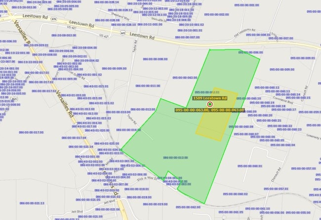
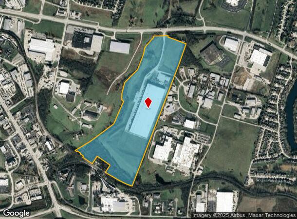
1509 Leestown Rd, Frankfort, KY 40601
NEARBY LISTINGS FOR SALE OR LEASE
Property Detail
1509 Leestown Rd
Frankfort, KY
Opb Ky Llc Property
095-00-00-063.02
TRACT B REV 92.21 ACRES
Commercialnec
Franklin
A
Kentucky
21073C0141D
b
2025
92.21 AC
2025
Kentucky East Area
070703
Other Market Areas
DEMOGRAPHICS near 1509 Leestown Rd
1 Mile
3 Mile
5 Mile
2024 Total Population
1,946
17,358
33,726
2029 Population
1,957
17,482
34,064
Pop Growth 2024-2029
+ 0.57%
+ 0.71%
+ 1.00%
Average Age
45
41
41
2024 Total Households
861
7,388
14,563
HH Growth 2024-2029
+ 0.58%
+ 0.73%
+ 1.05%
Median Household Inc
$86,988
$68,763
$61,229
Avg Household Size
2.30
2.30
2.20
2024 Avg HH Vehicles
2.00
2.00
2.00
Median Home Value
$267,856
$175,842
$171,594
Median Year Built
1990
1974
1972
Nearby Places
Map Layers
Map Styles
 Street
 Aerial
- Restaurants
- Banks
- Shops
- Fitness
- Groceries
PUBLIC TRANSPORTATION
AIRPORT
Blue Grass
DRIVE
WALK
Distance
Blue Grass
28 min
18.3 mi
Freight Ports
Port of Toledo
DRIVE
WALK
Distance
Port of Toledo
344 min
292.1 mi
Nearby Properties
Address
Land Use
TOTAL SIZE
Lot Size
Zoning
Address
Land Use
TOTAL SIZE
Lot Size
Zoning
600 SF
29.08 AC
Address
Land Use
TOTAL SIZE
Lot Size
Zoning
35.55 AC
Address
Land Use
TOTAL SIZE
Lot Size
Zoning
80.60 AC
Address
Land Use
TOTAL SIZE
Lot Size
Zoning
5.75 AC
Address
Land Use
TOTAL SIZE
Lot Size
Zoning
82.18 AC
Address
Land Use
TOTAL SIZE
Lot Size
Zoning
22.08 AC
Address
Land Use
TOTAL SIZE
Lot Size
Zoning
Address
Land Use
TOTAL SIZE
Lot Size
Zoning
13.85 AC
Address
Land Use
TOTAL SIZE
Lot Size
Zoning
Address
Land Use
TOTAL SIZE
Lot Size
Zoning
28.89 AC
Address
Land Use
TOTAL SIZE
Lot Size
Zoning
6.85 AC
Address
Land Use
TOTAL SIZE
Lot Size
Zoning
Address
Land Use
TOTAL SIZE
Lot Size
Zoning
95.41 AC
Address
Land Use
TOTAL SIZE
Lot Size
Zoning
14.76 AC
Address
Land Use
TOTAL SIZE
Lot Size
Zoning
5.60 AC
Address
Land Use
TOTAL SIZE
Lot Size
Zoning
20.21 AC
Address
Land Use
TOTAL SIZE
Lot Size
Zoning
3.40 AC
Address
Land Use
TOTAL SIZE
Lot Size
Zoning
2.06 AC
Address
Land Use
TOTAL SIZE
Lot Size
Zoning
25.38 AC
Address
Land Use
TOTAL SIZE
Lot Size
Zoning
16,800 SF
6.50 AC
Address
Land Use
TOTAL SIZE
Lot Size
Zoning
Address
Land Use
TOTAL SIZE
Lot Size
Zoning
11.74 AC
Address
Land Use
TOTAL SIZE
Lot Size
Zoning
Address
Land Use
TOTAL SIZE
Lot Size
Zoning
2.60 AC
Address
Land Use
TOTAL SIZE
Lot Size
Zoning
3.93 AC
Address
Land Use
TOTAL SIZE
Lot Size
Zoning
14.93 AC
Address
Land Use
TOTAL SIZE
Lot Size
Zoning
7.44 AC
Address
Land Use
TOTAL SIZE
Lot Size
Zoning
Address
Land Use
TOTAL SIZE
Lot Size
Zoning
The World's #1 Commercial Real Estate Marketplace
Connect with us
© 2026 CoStar Group
The information above has been obtained from sources believed reliable. While we do not doubt its accuracy we have not verified it and make no guarantee, warranty or representation about it. It is your responsibility to independently confirm its accuracy and completeness. Any projections, opinions, assumptions, or estimates used are for example only and do not represent the current or future performance of the property. The value of this transaction to you depends on tax and other factors which should be evaluated by your tax, financial, and legal advisors. You and your advisors should conduct a careful, independent investigation of the property to determine to your satisfaction the suitability of the property for your needs.