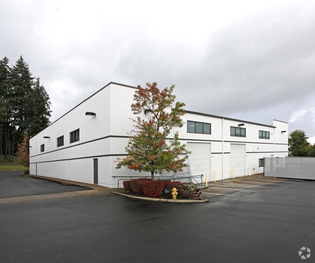
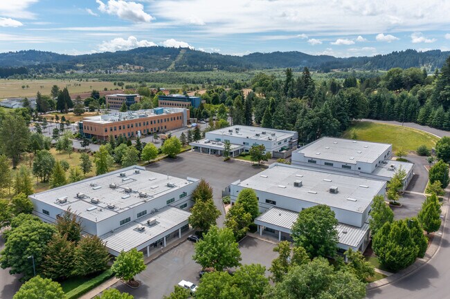
Property Record
1515 Westec Dr, Eugene, OR 97402

Property Detail
1515 Westec Dr
Eugene-Springfield, OR
TL 00200
1582897
Lane
Industrialgeneral
Oregon
E-2
200
B and X Area of moderate flood hazard, usually the area between the limits of the 100-year and 500-year floods.
2.91 AC
2025
Lane County
2025
Portland
001002
NEARBY LISTINGS FOR SALE OR LEASE
DEMOGRAPHICS near 1515 Westec Dr
1 mile
3 mile
5 mile
2025 Total Population
725
44,660
116,345
2030 Population
742
44,150
115,188
Pop Growth 2025-2030
+ 2.34%
(1.14%)
(0.99%)
Average Age
44
41
41
2025 Total Households
337
16,746
48,489
HH Growth 2025-2030
+ 2.08%
(1.28%)
(1.10%)
Median Household Inc
$36,666
$67,906
$63,134
Avg Household Size
2.10
2.40
2.20
2025 Avg HH Vehicles
2.00
2.00
2.00
Median Home Value
$940,971
$376,762
$428,114
Median Year Built
1991
1979
1975
Nearby Places
Map Layers
Map Styles
 Street
 Aerial
Transit
 Traffic
 Biking
Places
Listings with unknown addresses are not visible on the map
- Restaurants
- Banks
- Shops
- Fitness
- Groceries
PUBLIC TRANSPORTATION
COMMUTER RAIL
Drive
Walk
Distance
14 min
5.6 mi
AIRPORT
Mahlon Sweet Field
Drive
Walk
Distance
Mahlon Sweet Field
16 min
7.5 mi
SALE & LEASE HISTORY
LISTING DATE
SALE/LEASE

Jun 18, 2021
For Lease
Aug 31, 2017
For Lease
Aug 01, 2018
For Lease
Nearby Properties
Address
Land Use
TOTAL SIZE
Lot Size
Zoning
Address
Land Use
TOTAL SIZE
Lot Size
Zoning
44.56 AC
PL
Address
Land Use
TOTAL SIZE
Lot Size
Zoning
Address
Land Use
TOTAL SIZE
Lot Size
Zoning
12.12 AC
C-2
Address
Land Use
TOTAL SIZE
Lot Size
Zoning
45.78 AC
I-3
Address
Land Use
TOTAL SIZE
Lot Size
Zoning
75.36 AC
PL
Address
Land Use
TOTAL SIZE
Lot Size
Zoning
14.14 AC
R-1
Address
Land Use
TOTAL SIZE
Lot Size
Zoning
19.65 AC
C-2
Address
Land Use
TOTAL SIZE
Lot Size
Zoning
3,324 SF
8.70 AC
NR
Address
Land Use
TOTAL SIZE
Lot Size
Zoning
27.47 AC
R-1
Address
Land Use
TOTAL SIZE
Lot Size
Zoning
12.07 AC
NR
Address
Land Use
TOTAL SIZE
Lot Size
Zoning
29.96 AC
AG
Address
Land Use
TOTAL SIZE
Lot Size
Zoning
Address
Land Use
TOTAL SIZE
Lot Size
Zoning
33.70 AC
R-1
Address
Land Use
TOTAL SIZE
Lot Size
Zoning
37.58 AC
PL
Address
Land Use
TOTAL SIZE
Lot Size
Zoning
13.14 AC
I-2
Address
Land Use
TOTAL SIZE
Lot Size
Zoning
4.97 AC
I-3
Address
Land Use
TOTAL SIZE
Lot Size
Zoning
10.50 AC
C-2
Address
Land Use
TOTAL SIZE
Lot Size
Zoning
5.13 AC
I-3
Address
Land Use
TOTAL SIZE
Lot Size
Zoning
3.12 AC
I-2
Address
Land Use
TOTAL SIZE
Lot Size
Zoning
12.30 AC
C-2
Address
Land Use
TOTAL SIZE
Lot Size
Zoning
Address
Land Use
TOTAL SIZE
Lot Size
Zoning
16.18 AC
E-1
Address
Land Use
TOTAL SIZE
Lot Size
Zoning
11.13 AC
C-2
Address
Land Use
TOTAL SIZE
Lot Size
Zoning
25.02 AC
PL
Address
Land Use
TOTAL SIZE
Lot Size
Zoning
560 SF
11.02 AC
I-2
Address
Land Use
TOTAL SIZE
Lot Size
Zoning
2.32 AC
E-2
Address
Land Use
TOTAL SIZE
Lot Size
Zoning
13.55 AC
R-1
Address
Land Use
TOTAL SIZE
Lot Size
Zoning
9.46 AC
C-2
Address
Land Use
TOTAL SIZE
Lot Size
Zoning
3,980 SF
85.16 AC
AG
Address
Land Use
TOTAL SIZE
Lot Size
Zoning
2.93 AC
I-3
The World's #1 Commercial Real Estate Marketplace
Connect with us
© 2026 CoStar Group
The information above has been obtained from sources believed reliable. While we do not doubt its accuracy we have not verified it and make no guarantee, warranty or representation about it. It is your responsibility to independently confirm its accuracy and completeness. Any projections, opinions, assumptions, or estimates used are for example only and do not represent the current or future performance of the property. The value of this transaction to you depends on tax and other factors which should be evaluated by your tax, financial, and legal advisors. You and your advisors should conduct a careful, independent investigation of the property to determine to your satisfaction the suitability of the property for your needs.